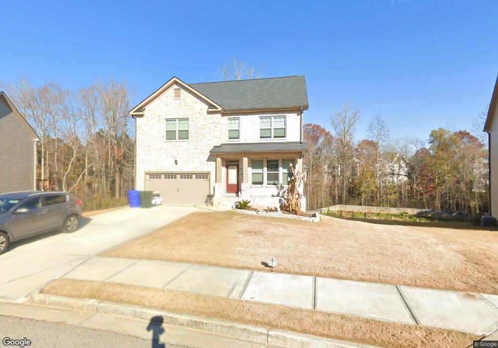
1249 Brookstone Cir Conyers, GA 30012
Estimated Value: $390,060 - $432,000
4
Beds
4
Baths
2,872
Sq Ft
$144/Sq Ft
Est. Value
About This Home
This home is located at 1249 Brookstone Cir, Conyers, GA 30012 and is currently estimated at $413,515, approximately $143 per square foot. 1249 Brookstone Cir is a home with nearby schools including Hicks Elementary School, Conyers Middle School, and Rockdale County High School.
Ownership History
Date
Name
Owned For
Owner Type
Purchase Details
Closed on
Mar 12, 2021
Sold by
Dr Horton Inc
Bought by
Brown Seree S and Brown Trayvon
Current Estimated Value
Home Financials for this Owner
Home Financials are based on the most recent Mortgage that was taken out on this home.
Original Mortgage
$312,308
Outstanding Balance
$278,197
Interest Rate
2.73%
Mortgage Type
FHA
Estimated Equity
$135,318
Purchase Details
Closed on
Nov 8, 2019
Sold by
Home South Development Llc
Bought by
D R Horton Inc
Create a Home Valuation Report for This Property
The Home Valuation Report is an in-depth analysis detailing your home's value as well as a comparison with similar homes in the area
Home Values in the Area
Average Home Value in this Area
Purchase History
| Date | Buyer | Sale Price | Title Company |
|---|---|---|---|
| Brown Seree S | $318,070 | -- | |
| D R Horton Inc | $815,596 | -- |
Source: Public Records
Mortgage History
| Date | Status | Borrower | Loan Amount |
|---|---|---|---|
| Open | Brown Seree S | $312,308 |
Source: Public Records
Tax History
| Year | Tax Paid | Tax Assessment Tax Assessment Total Assessment is a certain percentage of the fair market value that is determined by local assessors to be the total taxable value of land and additions on the property. | Land | Improvement |
|---|---|---|---|---|
| 2025 | $6,640 | $173,200 | $30,800 | $142,400 |
| 2024 | $6,798 | $181,320 | $31,920 | $149,400 |
| 2023 | $6,060 | $163,920 | $30,800 | $133,120 |
| 2022 | $4,907 | $134,120 | $24,240 | $109,880 |
| 2021 | $1,081 | $14,080 | $14,080 | $0 |
| 2020 | $801 | $12,880 | $12,880 | $0 |
| 2019 | $232 | $3,160 | $3,160 | $0 |
| 2018 | $142 | $3,160 | $3,160 | $0 |
| 2017 | $193 | $3,160 | $3,160 | $0 |
| 2016 | $194 | $3,160 | $3,160 | $0 |
| 2015 | $144 | $3,160 | $3,160 | $0 |
| 2014 | $55 | $1,200 | $1,200 | $0 |
| 2013 | -- | $1,200 | $1,200 | $0 |
Source: Public Records
Map
Nearby Homes
- 1669 E Brook Dr
- 1666 E Brook Dr
- 1260 Brookstone Cir
- 1262 Brookstone Cir
- 1308 Brookstone Lake Dr
- 1735 Hill St NE
- 1962 Bridgestone Cir
- 1640 Andalusian Way
- 1954 Bridgestone Cir
- 1915 Cornerstone Pass
- 1928 Cornerstone Pass
- 1794 Spring St NE
- 1729 Spring St NE
- 2131 Bridgestone Business Pkwy
- 1740 Spring St NE
- 1645 Main St NE
- 1617 Elm St NE
- 109 Ellis Dr
- 125 Ellis Dr
- 174 Ellis Dr
- 1251 Brookstone Cir
- 1247 Brookstone Cir
- 1238 Brookstone Cir
- 1253 Brookstone Cir
- 1245 Brookstone Cir
- 1245 Brookstone Cir Unit 23
- 1236 Brookstone Cir
- 1240 Brookstone Cir
- 1255 Brookstone Cir
- 1336 Brookstone Lake Dr
- 1243 Brookstone Cir
- 1242 Brookstone Cir
- 1334 Brookstone Lake Dr
- 1241 Brookstone Cir
- 1341 Brookstone Lake Dr
- 1675 E Brook Dr
- 1673 E Brook Dr
- 1635 E Brook Dr
- 1635 E Brook Dr Unit 119
- 1244 Brookstone Cir
Your Personal Tour Guide
Ask me questions while you tour the home.