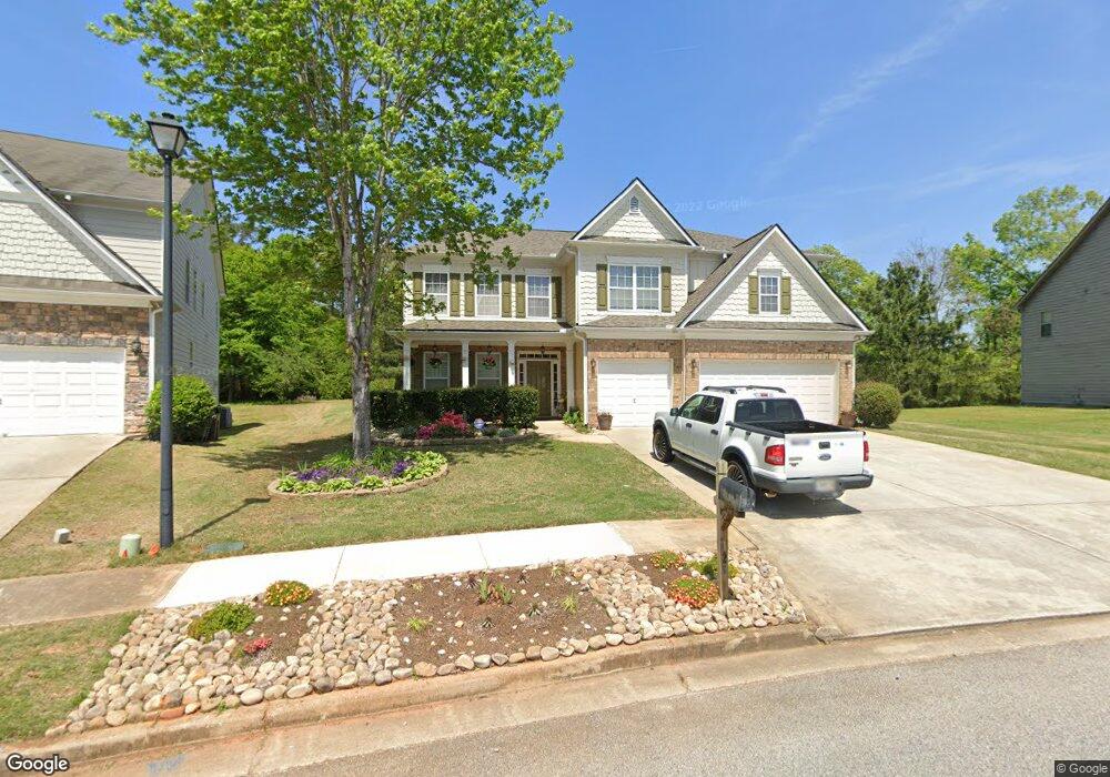
125 Homestead Way Covington, GA 30014
Estimated Value: $409,494 - $516,000
--
Bed
4
Baths
4,208
Sq Ft
$112/Sq Ft
Est. Value
About This Home
This home is located at 125 Homestead Way, Covington, GA 30014 and is currently estimated at $469,624, approximately $111 per square foot. 125 Homestead Way is a home located in Newton County with nearby schools including East Newton Elementary School, Cousins Middle School, and Eastside High School.
Ownership History
Date
Name
Owned For
Owner Type
Purchase Details
Closed on
Jul 12, 2006
Sold by
D R Horton Inc Of D R Horton I
Bought by
Wills Gene and Wills Kathy
Current Estimated Value
Home Financials for this Owner
Home Financials are based on the most recent Mortgage that was taken out on this home.
Original Mortgage
$204,444
Outstanding Balance
$120,635
Interest Rate
6.54%
Mortgage Type
New Conventional
Estimated Equity
$348,989
Purchase Details
Closed on
Oct 4, 2005
Sold by
River Walk Farm
Bought by
D R Horton Inc
Create a Home Valuation Report for This Property
The Home Valuation Report is an in-depth analysis detailing your home's value as well as a comparison with similar homes in the area
Home Values in the Area
Average Home Value in this Area
Purchase History
| Date | Buyer | Sale Price | Title Company |
|---|---|---|---|
| Wills Gene | $255,600 | -- | |
| D R Horton Inc | $1,370,400 | -- |
Source: Public Records
Mortgage History
| Date | Status | Borrower | Loan Amount |
|---|---|---|---|
| Open | Wills Gene | $204,444 |
Source: Public Records
Tax History Compared to Growth
Tax History
| Year | Tax Paid | Tax Assessment Tax Assessment Total Assessment is a certain percentage of the fair market value that is determined by local assessors to be the total taxable value of land and additions on the property. | Land | Improvement |
|---|---|---|---|---|
| 2024 | $1,485 | $173,200 | $21,600 | $151,600 |
| 2023 | $1,761 | $172,600 | $10,000 | $162,600 |
| 2022 | $3,736 | $139,280 | $10,000 | $129,280 |
| 2021 | $3,799 | $127,120 | $10,000 | $117,120 |
| 2020 | $3,701 | $112,520 | $10,000 | $102,520 |
| 2019 | $3,690 | $110,560 | $10,000 | $100,560 |
| 2018 | $3,450 | $102,880 | $10,000 | $92,880 |
| 2017 | $3,697 | $110,080 | $11,200 | $98,880 |
| 2016 | $2,606 | $78,280 | $9,000 | $69,280 |
| 2015 | $2,046 | $62,120 | $3,200 | $58,920 |
| 2014 | $2,041 | $62,120 | $0 | $0 |
Source: Public Records
Map
Nearby Homes
- 115 Sagebrush Trail
- 323 River Walk Farm
- 345 River Walk Farm Unit LOT 5
- 344 River Walk Farm
- 338 River Walk Farm
- 330 River Walk Farm
- 30 Asteria Trail
- 210 Kestrel Cir
- 55 Dearing Woods Bend Unit 5
- 55 Dearing Woods Bend
- 240 Kestrel Cir
- 20 Kestrel Cir
- 7762 Fawn Cir
- 30 Snapdragon Ln
- 20 Mariposa Place
- 295 River Walk Farm Pkwy
- 7703 Fawn Cir
- 312 River Walk Farm
- 345 River Walk Farm Pkwy Lot 5
- Jodeco Front Porch Plan at River Walk Farm
- 115 Homestead Way
- 135 Homestead Way
- 105 Homestead Way
- 105 Homestead Way Unit 21
- 75 Knollwood Place Unit 1
- 100 Homestead Way Unit 26
- 100 Homestead Way
- 65 Knollwood Place Unit 1
- 145 Homestead Way Unit LL227OF THE 9THDIST,
- 95 Homestead Way
- 80 Woodcliff Way
- 140 Homestead Way Unit 47
- 140 Homestead Way
- 90 Homestead Way Unit 27
- 90 Homestead Way
- 90 Homestead Way Unit 2
- 85 Homestead Way
- 165 Homestead Way
- 70 Knollwood Place Unit 1
- 60 Woodcliff Way