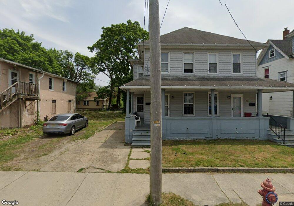
125 S Broad St Unit 127 Penns Grove, NJ 08069
Estimated Value: $166,000 - $325,000
--
Bed
--
Bath
3,024
Sq Ft
$83/Sq Ft
Est. Value
About This Home
This home is located at 125 S Broad St Unit 127, Penns Grove, NJ 08069 and is currently estimated at $250,228, approximately $82 per square foot. 125 S Broad St Unit 127 is a home located in Salem County with nearby schools including Lafayette-Pershing Elementary School, Paul W. Carleton Elementary School, and Field Street Elementary School.
Ownership History
Date
Name
Owned For
Owner Type
Purchase Details
Closed on
Oct 28, 2024
Sold by
Penns Grove Scattered Site Rehab Llc
Bought by
B & D Property Group Llc
Current Estimated Value
Purchase Details
Closed on
Dec 7, 2022
Sold by
Vanderwiel Zachary
Bought by
Fig 20 Llc
Purchase Details
Closed on
Jan 11, 2019
Sold by
Shinkle Bennett W and Shinkle Charlotte R
Bought by
125-127 S Broad St Land T
Purchase Details
Closed on
Sep 27, 2002
Sold by
Visalli Joseph A and Visalli Frances P
Bought by
Shinkle Bennett W and Shinkle Charlotte R
Home Financials for this Owner
Home Financials are based on the most recent Mortgage that was taken out on this home.
Original Mortgage
$68,400
Interest Rate
6.27%
Create a Home Valuation Report for This Property
The Home Valuation Report is an in-depth analysis detailing your home's value as well as a comparison with similar homes in the area
Home Values in the Area
Average Home Value in this Area
Purchase History
| Date | Buyer | Sale Price | Title Company |
|---|---|---|---|
| B & D Property Group Llc | -- | None Listed On Document | |
| B & D Property Group Llc | -- | None Listed On Document | |
| Fig 20 Llc | $436 | -- | |
| 125-127 S Broad St Land T | $60,000 | Title Masters Llc | |
| Shinkle Bennett W | $76,000 | Heritage Title & Abstract |
Source: Public Records
Mortgage History
| Date | Status | Borrower | Loan Amount |
|---|---|---|---|
| Previous Owner | Shinkle Bennett W | $68,400 |
Source: Public Records
Tax History Compared to Growth
Tax History
| Year | Tax Paid | Tax Assessment Tax Assessment Total Assessment is a certain percentage of the fair market value that is determined by local assessors to be the total taxable value of land and additions on the property. | Land | Improvement |
|---|---|---|---|---|
| 2025 | $6,683 | $120,500 | $23,500 | $97,000 |
| 2024 | $6,459 | $120,500 | $23,500 | $97,000 |
| 2023 | $6,459 | $120,500 | $23,500 | $97,000 |
| 2022 | $6,226 | $120,500 | $23,500 | $97,000 |
| 2021 | $5,955 | $120,500 | $23,500 | $97,000 |
| 2020 | $6,036 | $120,500 | $23,500 | $97,000 |
| 2019 | $6,061 | $120,500 | $23,500 | $97,000 |
| 2018 | $6,067 | $150,400 | $20,500 | $129,900 |
| 2017 | $6,088 | $150,400 | $20,500 | $129,900 |
| 2016 | $5,858 | $150,400 | $20,500 | $129,900 |
| 2015 | $5,611 | $150,400 | $20,500 | $129,900 |
| 2014 | $5,550 | $150,400 | $20,500 | $129,900 |
Source: Public Records
Map
Nearby Homes
- 106 S Broad St
- 65 S Broad St
- 85 State St
- 15 Walnut St
- 80 S Broad St
- 32 Westminster Ave
- 106 Sack Ave
- 32 Walnut St
- 55 57 Walnut St
- 59-61 Walnut St
- 34 38 Cumberland Ave
- 39 41 Cumberland Ave
- 204 206 S Broad St
- 0 Lincoln Avenue & Cumberland
- 88 Railroad Ave
- 114 Deming Ave
- 0 Delaware Dr
- 0 Park Ave Unit NJSA2013690
- 83 Willis St
- 91 Mill St
- 125-127 S Broad St
- 129 S Broad St
- 119 S Broad St
- 119 Tyrone Ave
- 3 Willis St
- 114 S Broad St
- 124 S Broad St
- 120 S Broad St
- 120 S Broad St Unit 18
- 126 S Broad St
- 105 S Broad St
- 128 S Broad St
- 120 Tyrone Ave
- 118 Tyrone Ave
- 132 S Broad St
- 136 S Broad St
- 138 S Broad St Unit 140
- 138-140 S Broad St
- 101 S Broad St
- 114 Tyrone Ave