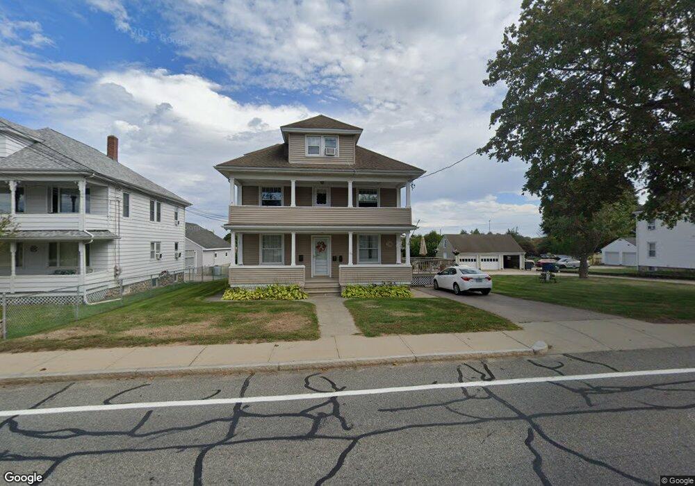
125 Tower St Westerly, RI 02891
Estimated Value: $339,281 - $644,000
1
Bed
3
Baths
800
Sq Ft
$620/Sq Ft
Est. Value
About This Home
This home is located at 125 Tower St, Westerly, RI 02891 and is currently estimated at $496,320, approximately $620 per square foot. 125 Tower St is a home located in Washington County with nearby schools including Westerly High School and St. Michael School.
Ownership History
Date
Name
Owned For
Owner Type
Purchase Details
Closed on
Aug 3, 2018
Sold by
Carboni Ronald
Bought by
Carboni Dean S
Current Estimated Value
Purchase Details
Closed on
May 30, 2018
Sold by
Carboni Bernice V Est
Bought by
Carboni Carl L and Carboni Ronald
Purchase Details
Closed on
Mar 17, 2011
Sold by
Giorno Carmela and Carboni Bernice V
Bought by
Lamb Nikki K and Lamb Zachary R
Home Financials for this Owner
Home Financials are based on the most recent Mortgage that was taken out on this home.
Original Mortgage
$115,000
Interest Rate
4.83%
Create a Home Valuation Report for This Property
The Home Valuation Report is an in-depth analysis detailing your home's value as well as a comparison with similar homes in the area
Home Values in the Area
Average Home Value in this Area
Purchase History
| Date | Buyer | Sale Price | Title Company |
|---|---|---|---|
| Carboni Dean S | -- | -- | |
| Carboni Carl L | -- | -- | |
| Lamb Nikki K | $140,350 | -- |
Source: Public Records
Mortgage History
| Date | Status | Borrower | Loan Amount |
|---|---|---|---|
| Previous Owner | Lamb Nikki K | $115,000 | |
| Previous Owner | Lamb Nikki K | $26,000 |
Source: Public Records
Tax History Compared to Growth
Tax History
| Year | Tax Paid | Tax Assessment Tax Assessment Total Assessment is a certain percentage of the fair market value that is determined by local assessors to be the total taxable value of land and additions on the property. | Land | Improvement |
|---|---|---|---|---|
| 2025 | $4,667 | $599,900 | $150,700 | $449,200 |
| 2024 | $4,043 | $386,900 | $109,500 | $277,400 |
| 2023 | $3,931 | $386,900 | $109,500 | $277,400 |
| 2022 | $3,908 | $386,900 | $109,500 | $277,400 |
| 2021 | $4,027 | $333,900 | $96,100 | $237,800 |
| 2020 | $3,957 | $333,900 | $96,100 | $237,800 |
| 2019 | $4,186 | $356,600 | $96,100 | $260,500 |
| 2018 | $3,549 | $287,400 | $96,100 | $191,300 |
| 2017 | $3,449 | $287,400 | $96,100 | $191,300 |
| 2016 | $3,449 | $287,400 | $96,100 | $191,300 |
| 2015 | $3,359 | $299,100 | $97,900 | $201,200 |
| 2014 | $3,305 | $299,100 | $97,900 | $201,200 |
Source: Public Records
Map
Nearby Homes
- 6 Tidewinds Ln
- 52 Spruce St
- 145 High St Unit D
- 140 High St Unit 307
- 9 Ward Ave
- 0 Iroquois Ave
- 38 Newton Ave
- 19 Pleasant St
- 223 High St Unit S
- 4 Pearl St
- 17 Apache Dr Unit G
- 94 Ashaway Rd
- 57 School St
- 9 Apache Dr Unit C
- 67 Cross St
- 23 Hillview Dr
- 101 Ashaway Rd
- 16 Boiling Spring Ave
- 25 School St Unit 4
- 25 School St Unit 2
- 125 Tower St
- 125 Tower St Unit 2ndFl
- 125 Tower St Unit 3
- 125 Tower St Unit 1
- 127 Tower St
- 129 Tower St
- 119 Tower St
- 119 Tower St Unit 2
- 132 Tower St
- 13 Harrison Ave
- 117 Tower St
- 11 Harrison Ave
- 15 Harrison Ave
- 131 Tower St
- 124 Tower St
- 120 Tower St
- 134 Tower St
- 9 Harrison Ave
- 7 Batterson Ave
- 17 Harrison Ave