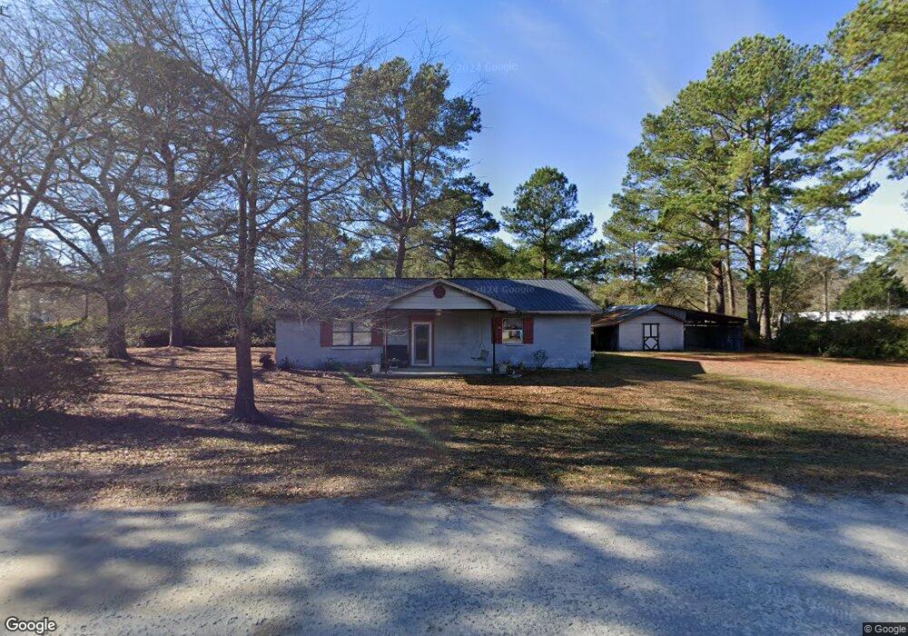
125 Wilson Ave Richlands, NC 28574
Estimated Value: $61,000 - $259,000
2
Beds
1
Bath
1,632
Sq Ft
$89/Sq Ft
Est. Value
About This Home
This home is located at 125 Wilson Ave, Richlands, NC 28574 and is currently estimated at $145,048, approximately $88 per square foot. 125 Wilson Ave is a home located in Onslow County with nearby schools including Richlands Elementary School, Trexler Middle School, and Richlands High School.
Ownership History
Date
Name
Owned For
Owner Type
Purchase Details
Closed on
Jun 10, 2025
Sold by
Taylor Robert and Taylor Abby
Bought by
Thomas Weston Billy and Thomas Angel Marie
Current Estimated Value
Purchase Details
Closed on
Dec 18, 2018
Sold by
Parker Donald R and Parker Katherine H
Bought by
Westbrook Kenneth and Westbrook Sylvia
Purchase Details
Closed on
Dec 1, 2011
Sold by
Syemour Terry L
Bought by
Taylor Robert Lee and Taylor Abby Gail
Purchase Details
Closed on
Dec 5, 2008
Sold by
Batchelor Annette and Batchelor William Troy
Bought by
Taylor Robert and Taylor Abby
Create a Home Valuation Report for This Property
The Home Valuation Report is an in-depth analysis detailing your home's value as well as a comparison with similar homes in the area
Home Values in the Area
Average Home Value in this Area
Purchase History
| Date | Buyer | Sale Price | Title Company |
|---|---|---|---|
| Thomas Weston Billy | $60,000 | None Listed On Document | |
| Thomas Weston Billy | $60,000 | None Listed On Document | |
| Westbrook Kenneth | $550,000 | None Available | |
| Taylor Robert Lee | $35,000 | None Available | |
| Taylor Robert | $60,000 | None Available |
Source: Public Records
Tax History Compared to Growth
Tax History
| Year | Tax Paid | Tax Assessment Tax Assessment Total Assessment is a certain percentage of the fair market value that is determined by local assessors to be the total taxable value of land and additions on the property. | Land | Improvement |
|---|---|---|---|---|
| 2025 | $614 | $93,796 | $22,500 | $71,296 |
| 2024 | $614 | $93,796 | $22,500 | $71,296 |
| 2023 | $614 | $93,796 | $22,500 | $71,296 |
| 2022 | $614 | $93,796 | $22,500 | $71,296 |
| 2021 | $509 | $72,190 | $16,500 | $55,690 |
| 2020 | $509 | $72,190 | $16,500 | $55,690 |
| 2019 | $509 | $72,190 | $16,500 | $55,690 |
| 2018 | $509 | $72,190 | $16,500 | $55,690 |
| 2017 | $493 | $72,990 | $16,500 | $56,490 |
| 2016 | $493 | $72,990 | $0 | $0 |
| 2015 | $493 | $72,990 | $0 | $0 |
| 2014 | $493 | $72,990 | $0 | $0 |
Source: Public Records
Map
Nearby Homes
- 601 Central Park Way
- 749 Greenwich Place
- 745 Greenwich Place
- Plan 1522 at Waverly Place
- Plan 1830 at Waverly Place
- Plan 2604 at Waverly Place
- Plan 1727 at Waverly Place
- Plan 1634 at Waverly Place
- 751 Greenwich Place
- Plan 1434 at Waverly Place
- Plan 3105 at Waverly Place
- 722 Greenwich Place
- 149 Huffmantown Rd
- 580 Koonce Fork Rd
- 978 Kinston Hwy
- 424 Huffmantown Rd
- 444 Huffmantown
- 304 W Foy St
- 226 Beulaville Hwy
- 523 Huffmantown Rd