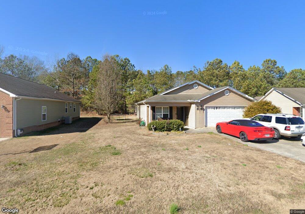
1250 Brookstone Cir Dalton, GA 30721
Estimated Value: $237,161 - $268,000
3
Beds
2
Baths
1,325
Sq Ft
$191/Sq Ft
Est. Value
About This Home
This home is located at 1250 Brookstone Cir, Dalton, GA 30721 and is currently estimated at $252,540, approximately $190 per square foot. 1250 Brookstone Cir is a home located in Whitfield County with nearby schools including Valley Point Elementary School, Valley Point Middle School, and Southeast Whitfield County High School.
Ownership History
Date
Name
Owned For
Owner Type
Purchase Details
Closed on
Oct 15, 2007
Sold by
Not Provided
Bought by
Gibson April A
Current Estimated Value
Home Financials for this Owner
Home Financials are based on the most recent Mortgage that was taken out on this home.
Original Mortgage
$134,580
Outstanding Balance
$82,660
Interest Rate
6.26%
Mortgage Type
FHA
Estimated Equity
$169,880
Purchase Details
Closed on
Apr 19, 2007
Sold by
Not Provided
Bought by
Gibson April A
Create a Home Valuation Report for This Property
The Home Valuation Report is an in-depth analysis detailing your home's value as well as a comparison with similar homes in the area
Purchase History
| Date | Buyer | Sale Price | Title Company |
|---|---|---|---|
| Gibson April A | $135,700 | -- | |
| Gibson April A | $499,500 | -- |
Source: Public Records
Mortgage History
| Date | Status | Borrower | Loan Amount |
|---|---|---|---|
| Open | Gibson April A | $134,580 |
Source: Public Records
Tax History
| Year | Tax Paid | Tax Assessment Tax Assessment Total Assessment is a certain percentage of the fair market value that is determined by local assessors to be the total taxable value of land and additions on the property. | Land | Improvement |
|---|---|---|---|---|
| 2025 | $1,580 | $76,786 | $11,600 | $65,186 |
| 2024 | $1,580 | $76,786 | $11,600 | $65,186 |
| 2023 | $1,609 | $60,618 | $11,000 | $49,618 |
| 2022 | $1,266 | $51,464 | $11,000 | $40,464 |
| 2021 | $1,266 | $51,464 | $11,000 | $40,464 |
| 2020 | $1,297 | $51,464 | $11,000 | $40,464 |
| 2019 | $1,313 | $51,464 | $11,000 | $40,464 |
| 2018 | $1,139 | $45,438 | $6,800 | $38,638 |
| 2017 | $1,139 | $45,438 | $6,800 | $38,638 |
| 2016 | $1,003 | $41,942 | $6,800 | $35,142 |
| 2014 | $930 | $41,942 | $6,800 | $35,142 |
| 2013 | -- | $41,942 | $6,800 | $35,142 |
Source: Public Records
Map
Nearby Homes
- 586 Collington Cir
- 321 Collington Cir
- 282 Collington Cir
- 162 Valley Point Dr SE
- 147 Toria Trace
- 3737 S Dixie Hwy
- 3950 S Dixie Hwy
- 0 Waterfront Way
- 3950 S Dixie Rd
- 139 Waterfront Way
- 169 Waterfront Way
- 112 Robin Hood Dr
- 116 Robin Hood Dr
- 122 Robin Hood Dr Unit A,B
- 122 Robin Hood Dr
- 124 Robin Hood Dr
- 000 S Dixie Hwy
- 171 Maurine Dr
- 243 Gaz Rd SE
- 0 Old Dixie Hwy
- 1260 Brookstone Cir
- 1240 Brookstone Cir
- 43 Brookstone Cir
- 45 Brookstone Cir
- 42 Brookstone Cir
- 38 Brookstone Cir
- 37 Brookstone Cir
- 36 Brookstone Cir
- 35 Brookstone Cir
- 34 Brookstone Cir
- 21 Brookstone Cir
- 4 Brookstone Cir
- 3 Brookstone Cir
- 1235 Brookstone Cir
- 1270 Brookstone Cir
- 1230 Brookstone Cir
- 1255 Brookstone Cir
- 1265 Brookstone Cir
- 1280 Brookstone Cir
- 1275 Brookstone Cir
Your Personal Tour Guide
Ask me questions while you tour the home.