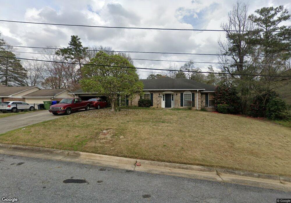
1250 Knight Dr Columbus, GA 31906
Lindsey Creek Park-Boxwood Estates NeighborhoodEstimated Value: $170,244 - $200,000
3
Beds
3
Baths
1,883
Sq Ft
$97/Sq Ft
Est. Value
About This Home
This home is located at 1250 Knight Dr, Columbus, GA 31906 and is currently estimated at $182,561, approximately $96 per square foot. 1250 Knight Dr is a home located in Muscogee County with nearby schools including Rigdon Road Elementary School, Richards Middle School, and Hardaway High School.
Ownership History
Date
Name
Owned For
Owner Type
Purchase Details
Closed on
Dec 1, 2010
Sold by
Barker Pamela Kay and Barker Pamela K
Bought by
Williams Carrie R and Williams Jimmie
Current Estimated Value
Home Financials for this Owner
Home Financials are based on the most recent Mortgage that was taken out on this home.
Original Mortgage
$77,000
Interest Rate
4.3%
Mortgage Type
New Conventional
Create a Home Valuation Report for This Property
The Home Valuation Report is an in-depth analysis detailing your home's value as well as a comparison with similar homes in the area
Home Values in the Area
Average Home Value in this Area
Purchase History
| Date | Buyer | Sale Price | Title Company |
|---|---|---|---|
| Williams Carrie R | $117,000 | None Available |
Source: Public Records
Mortgage History
| Date | Status | Borrower | Loan Amount |
|---|---|---|---|
| Previous Owner | Williams Carrie R | $77,000 |
Source: Public Records
Tax History
| Year | Tax Paid | Tax Assessment Tax Assessment Total Assessment is a certain percentage of the fair market value that is determined by local assessors to be the total taxable value of land and additions on the property. | Land | Improvement |
|---|---|---|---|---|
| 2025 | $2,175 | $55,556 | $5,924 | $49,632 |
| 2024 | $2,175 | $55,556 | $5,924 | $49,632 |
| 2023 | $219 | $55,556 | $5,924 | $49,632 |
| 2022 | $1,994 | $48,840 | $5,924 | $42,916 |
| 2021 | $1,996 | $48,772 | $5,924 | $42,848 |
| 2020 | $1,992 | $48,772 | $5,924 | $42,848 |
| 2019 | $1,998 | $48,772 | $5,924 | $42,848 |
| 2018 | $1,998 | $48,772 | $5,924 | $42,848 |
| 2017 | $2,005 | $48,772 | $5,924 | $42,848 |
| 2016 | $1,931 | $46,800 | $5,231 | $41,569 |
| 2015 | $773 | $46,800 | $5,231 | $41,569 |
| 2014 | $1,935 | $46,800 | $5,231 | $41,569 |
| 2013 | -- | $46,800 | $5,231 | $41,569 |
Source: Public Records
Map
Nearby Homes
- 3474 Melrose Dr
- 1448 Cypress Ridge Dr
- 1043 Vera Dr
- 1104 Dunbar Ave
- 1232 Alta Vista Dr
- 1061 Dunbar Ave
- 937 Diggs Ave
- 3562 Woodland Dr
- 3122 Glenwood Dr
- 3319 Decatur St
- 2920 Schaul St
- 3035 Morehouse St
- 1035 Fisk Ave
- 1047 Fisk Ave
- 2916 Gardenia St
- 944 Booker Ave
- 939 Pembrook Dr
- 2917 Gardenia St
- 2911 Gardenia St
- 2921 Hood St
Your Personal Tour Guide
Ask me questions while you tour the home.