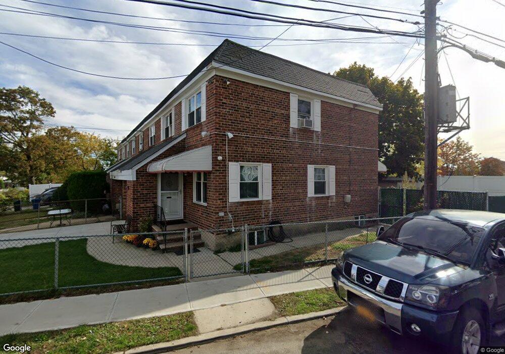
12502 Defoe St Springfield Gardens, NY 11413
Saint Albans NeighborhoodEstimated Value: $640,000 - $724,000
--
Bed
--
Bath
1,325
Sq Ft
$510/Sq Ft
Est. Value
About This Home
This home is located at 12502 Defoe St, Springfield Gardens, NY 11413 and is currently estimated at $675,878, approximately $510 per square foot. 12502 Defoe St is a home located in Queens County with nearby schools including P.S. 15 Jackie Robinson, Is 59 Springfield Gardens, and Success Academy Springfield Gardens.
Ownership History
Date
Name
Owned For
Owner Type
Purchase Details
Closed on
Dec 31, 2013
Sold by
Therese Dirr As Exeutrix
Bought by
Thompson Lawana
Current Estimated Value
Home Financials for this Owner
Home Financials are based on the most recent Mortgage that was taken out on this home.
Original Mortgage
$275,500
Outstanding Balance
$207,186
Interest Rate
4.29%
Mortgage Type
New Conventional
Estimated Equity
$468,692
Create a Home Valuation Report for This Property
The Home Valuation Report is an in-depth analysis detailing your home's value as well as a comparison with similar homes in the area
Home Values in the Area
Average Home Value in this Area
Purchase History
| Date | Buyer | Sale Price | Title Company |
|---|---|---|---|
| Thompson Lawana | $290,000 | -- |
Source: Public Records
Mortgage History
| Date | Status | Borrower | Loan Amount |
|---|---|---|---|
| Open | Thompson Lawana | $275,500 |
Source: Public Records
Tax History Compared to Growth
Tax History
| Year | Tax Paid | Tax Assessment Tax Assessment Total Assessment is a certain percentage of the fair market value that is determined by local assessors to be the total taxable value of land and additions on the property. | Land | Improvement |
|---|---|---|---|---|
| 2025 | $5,132 | $27,083 | $11,442 | $15,641 |
| 2024 | $5,132 | $25,550 | $12,931 | $12,619 |
| 2023 | $4,842 | $24,106 | $10,433 | $13,673 |
| 2022 | $4,768 | $34,440 | $14,880 | $19,560 |
| 2021 | $5,027 | $33,060 | $14,880 | $18,180 |
| 2020 | $4,777 | $28,440 | $14,880 | $13,560 |
| 2019 | $4,454 | $26,640 | $14,880 | $11,760 |
| 2018 | $4,095 | $20,088 | $13,007 | $7,081 |
| 2017 | $4,058 | $19,905 | $11,374 | $8,531 |
| 2016 | $3,979 | $19,905 | $11,374 | $8,531 |
| 2015 | $1,797 | $18,808 | $10,466 | $8,342 |
| 2014 | $1,797 | $17,744 | $11,848 | $5,896 |
Source: Public Records
Map
Nearby Homes
- 187-04 Williamson Ave
- 187-16 Williamson Ave
- 187-01 Ridgedale St
- 12512 Nepton St
- 18806 Nashville Blvd
- 21608 Merrick Blvd
- 21611 135th Ave
- 12251 Grayson St
- 12248 Benton St
- 12253 Milburn St
- 122-66 Nellis St
- 12244 Nellis St
- 19115 Williamson Ave
- 216-25 136th Rd Unit 1, Unit 2 and U
- 218-36 133rd Rd
- 122-22 Nellis St
- 192-17 Williamson Ave
- 19009 122nd Ave
- 17913 134th Ave
- 191-01 122nd Ave
- 125-8 Defoe St
- 125-02 Defoe St
- 125-04 Pineville Ln
- 18645 Pineville Ln
- 12506 Defoe St
- 125-06 Pineville Ln
- 12508 Defoe St
- 125-08 Pineville Ln
- 18625 Merrick Blvd
- 18623 Pineville Ln
- 18623 Pineville Ln
- 186-25 Pineville Ln
- 18625 Pineville Ln
- 18623 Pineville Ln
- 18629 Pineville Ln
- 186-29 Pineville Ln
- 125-15 Defoe St
- 18702 Pineville Ln
- 18619 Pineville Ln
- 18701 Pineville Ln