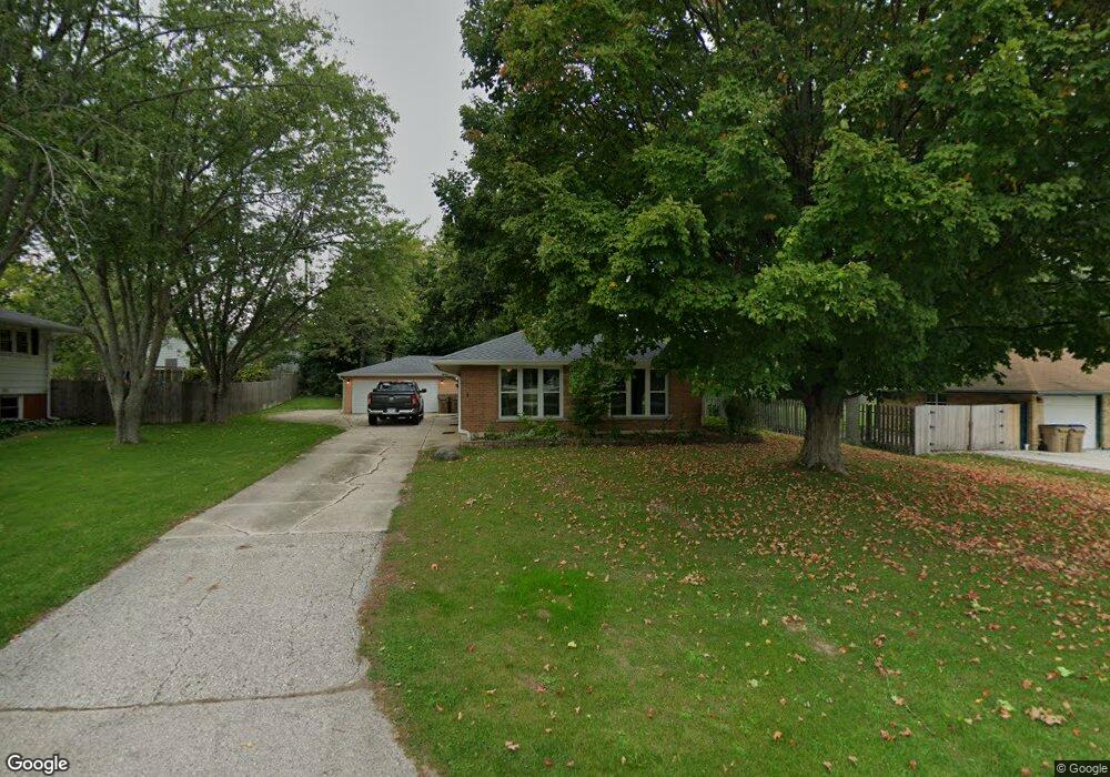
12504 39th Ave Pleasant Prairie, WI 53158
Village of Pleasant Prairie NeighborhoodEstimated Value: $250,000 - $292,000
3
Beds
1
Bath
1,134
Sq Ft
$241/Sq Ft
Est. Value
About This Home
This home is located at 12504 39th Ave, Pleasant Prairie, WI 53158 and is currently estimated at $273,189, approximately $240 per square foot. 12504 39th Ave is a home located in Kenosha County with nearby schools including Prairie Lane Elementary School, Lance Middle School, and Tremper High School.
Ownership History
Date
Name
Owned For
Owner Type
Purchase Details
Closed on
Mar 18, 2020
Sold by
Kaht Jeremy J and Losch Erin
Bought by
Losch William
Current Estimated Value
Purchase Details
Closed on
Sep 27, 2006
Sold by
French Michael J and French Terry A
Bought by
Kaht Jeremy J and Losch Erin
Home Financials for this Owner
Home Financials are based on the most recent Mortgage that was taken out on this home.
Original Mortgage
$160,000
Interest Rate
6.58%
Mortgage Type
New Conventional
Create a Home Valuation Report for This Property
The Home Valuation Report is an in-depth analysis detailing your home's value as well as a comparison with similar homes in the area
Home Values in the Area
Average Home Value in this Area
Purchase History
| Date | Buyer | Sale Price | Title Company |
|---|---|---|---|
| Losch William | $165,000 | Knight Barry Title | |
| Kaht Jeremy J | $175,000 | None Available |
Source: Public Records
Mortgage History
| Date | Status | Borrower | Loan Amount |
|---|---|---|---|
| Previous Owner | Kaht Jeremy J | $160,000 |
Source: Public Records
Tax History Compared to Growth
Tax History
| Year | Tax Paid | Tax Assessment Tax Assessment Total Assessment is a certain percentage of the fair market value that is determined by local assessors to be the total taxable value of land and additions on the property. | Land | Improvement |
|---|---|---|---|---|
| 2024 | $2,916 | $250,200 | $64,000 | $186,200 |
| 2023 | $2,924 | $217,700 | $58,200 | $159,500 |
| 2022 | $2,967 | $217,700 | $58,200 | $159,500 |
| 2021 | $2,766 | $147,200 | $47,000 | $100,200 |
| 2020 | $2,794 | $147,200 | $47,000 | $100,200 |
| 2019 | $2,405 | $147,200 | $47,000 | $100,200 |
| 2018 | $2,578 | $147,200 | $47,000 | $100,200 |
| 2017 | $2,816 | $130,500 | $42,800 | $87,700 |
| 2016 | $2,781 | $130,500 | $42,800 | $87,700 |
| 2015 | $2,401 | $124,400 | $40,700 | $83,700 |
| 2014 | $2,428 | $124,400 | $40,700 | $83,700 |
Source: Public Records
Map
Nearby Homes
- Lt0 39th Ave
- Lt0 128th St
- 11279 W Russell Rd
- 210 Oak Ln
- 43100 N Lewis Ave
- 12122 28th Ave
- 12111 28th Ave
- 432 Megan Place
- 436 Megan Place
- 429 Megan Place
- 42908 N Lewis Ave
- Lt5 113th St
- Deerfield Plan at Cedar Ridge
- Essex Plan at Cedar Ridge
- Geneva Plan at Cedar Ridge
- Ellington Plan at Cedar Ridge
- Summerhill Plan at Cedar Ridge
- Harlow Plan at Cedar Ridge
- Norwood Plan at Cedar Ridge
- Andover Plan at Cedar Ridge
- 12458 39th Ave
- 12514 39th Ave
- 12507 41st Ave
- 12501 41st Ave
- 12515 41st Ave
- 12457 41st Ave
- 12450 39th Ave
- 12524 39th Ave
- 4000 125th Place
- 12449 41st Ave
- 4004 125th Place
- 12440 39th Ave
- 12443 41st Ave
- 12501 39th Ave
- 12437 41st Ave
- 12432 39th Ave
- 3840 125th St
- 3839 125th St
- 12426 39th Ave
- 12429 41st Ave