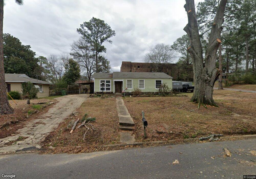
1251 Avondale Rd Montgomery, AL 36109
East Montgomery NeighborhoodEstimated Value: $76,000 - $98,346
--
Bed
--
Bath
1,422
Sq Ft
$65/Sq Ft
Est. Value
About This Home
This home is located at 1251 Avondale Rd, Montgomery, AL 36109 and is currently estimated at $92,087, approximately $64 per square foot. 1251 Avondale Rd is a home located in Montgomery County with nearby schools including Flowers Elementary School, Goodwyn Middle School, and Dr. Percy L. Julian High School.
Ownership History
Date
Name
Owned For
Owner Type
Purchase Details
Closed on
Jul 27, 2007
Sold by
Brakefield Brakefield Mary C Mary C and Brakefield Middleton Mary Catherine
Bought by
Mitchell John M
Current Estimated Value
Home Financials for this Owner
Home Financials are based on the most recent Mortgage that was taken out on this home.
Original Mortgage
$65,502
Outstanding Balance
$41,261
Interest Rate
6.65%
Mortgage Type
Purchase Money Mortgage
Estimated Equity
$50,826
Create a Home Valuation Report for This Property
The Home Valuation Report is an in-depth analysis detailing your home's value as well as a comparison with similar homes in the area
Home Values in the Area
Average Home Value in this Area
Purchase History
| Date | Buyer | Sale Price | Title Company |
|---|---|---|---|
| Mitchell John M | -- | None Available |
Source: Public Records
Mortgage History
| Date | Status | Borrower | Loan Amount |
|---|---|---|---|
| Open | Mitchell John M | $65,502 |
Source: Public Records
Tax History Compared to Growth
Tax History
| Year | Tax Paid | Tax Assessment Tax Assessment Total Assessment is a certain percentage of the fair market value that is determined by local assessors to be the total taxable value of land and additions on the property. | Land | Improvement |
|---|---|---|---|---|
| 2025 | $688 | $7,090 | $1,200 | $5,890 |
| 2024 | $695 | $7,090 | $1,200 | $5,890 |
| 2023 | $695 | $5,430 | $1,200 | $4,230 |
| 2022 | $419 | $5,740 | $1,200 | $4,540 |
| 2021 | $312 | $8,560 | $2,400 | $6,160 |
| 2020 | $292 | $4,000 | $1,200 | $2,800 |
| 2019 | $295 | $4,040 | $1,200 | $2,840 |
| 2018 | $319 | $4,370 | $1,200 | $3,170 |
| 2017 | $310 | $8,500 | $2,400 | $6,100 |
| 2014 | $331 | $4,538 | $1,200 | $3,338 |
| 2013 | -- | $4,230 | $1,200 | $3,030 |
Source: Public Records
Map
Nearby Homes
- 1708 Shoreham Dr
- 1102 Jameswood Ct
- Harrison Plan at Windsor Hill
- Douglas Plan at Windsor Hill
- Grant Plan at Windsor Hill
- Plan 2175 - Carroll at Windsor Hill
- Campbell Plan at Windsor Hill
- 3719 Windsor Hill Blvd
- 3604 Silver Ln
- 1229 Karen Rd
- 1705 Windsor Hill Ln
- 3718 Windsor Hill Blvd
- 3707 Donigle Park
- 3518 Silver Ln
- 3904 Bienville Rd
- 1641 Cairnbrook Dr
- 1809 Vaughn Ln
- 814 Avondale Rd
- 1128 Karen Rd
- 809 Perry Hill Rd
- 1245 Avondale Rd
- 3802 Farwood Dr
- 3808 Farwood Dr
- 1239 Avondale Rd
- 3721 Farwood Dr
- 3726 Farwood Dr
- 1246 Avondale Rd
- 1233 Avondale Rd
- 3720 Farwood Dr
- 1240 Avondale Rd
- 3711 Farwood Dr
- 1227 Avondale Rd
- 3714 Farwood Dr
- 1234 Avondale Rd
- 1221 Avondale Rd
- 1228 Avondale Rd
- 3701 Farwood Dr
- 1245 Beechdale Rd
- 3708 Farwood Dr
- 1239 Beechdale Rd