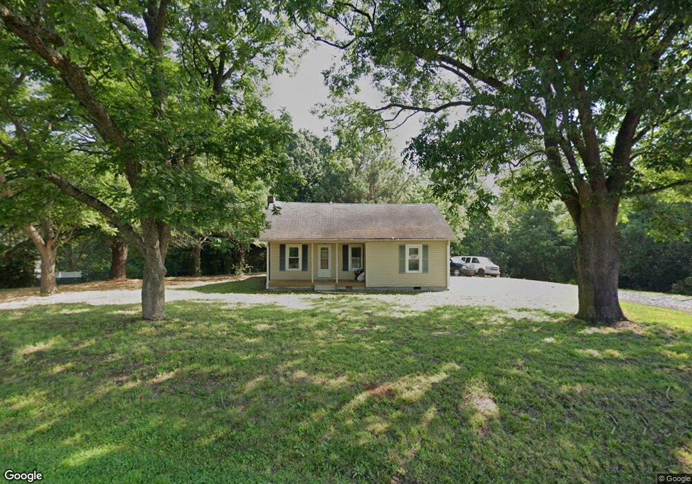
1251 Wilson Rd Linwood, NC 27299
Estimated Value: $146,253 - $254,000
2
Beds
1
Bath
1,152
Sq Ft
$163/Sq Ft
Est. Value
About This Home
This home is located at 1251 Wilson Rd, Linwood, NC 27299 and is currently estimated at $187,418, approximately $162 per square foot. 1251 Wilson Rd is a home located in Davidson County with nearby schools including Churchland Elementary School, Tyro Middle School, and West Davidson High School.
Ownership History
Date
Name
Owned For
Owner Type
Purchase Details
Closed on
Oct 20, 2022
Sold by
Teague Brandon Alan and Teague Brittany Renee
Bought by
Phillips Joshua L and Phillips Shelli W
Current Estimated Value
Purchase Details
Closed on
Feb 10, 2017
Sold by
Starr John and Starr Joann
Bought by
Teague Brandon Alan and Combs Brittany Renee
Purchase Details
Closed on
Nov 19, 1999
Sold by
Rorrer Patricia
Bought by
Chambers Patricia Celia
Purchase Details
Closed on
Jun 1, 1996
Purchase Details
Closed on
Aug 1, 1977
Create a Home Valuation Report for This Property
The Home Valuation Report is an in-depth analysis detailing your home's value as well as a comparison with similar homes in the area
Home Values in the Area
Average Home Value in this Area
Purchase History
| Date | Buyer | Sale Price | Title Company |
|---|---|---|---|
| Phillips Joshua L | $4,000 | -- | |
| Teague Brandon Alan | -- | None Available | |
| Chambers Patricia Celia | -- | -- | |
| -- | -- | -- | |
| -- | -- | -- |
Source: Public Records
Tax History Compared to Growth
Tax History
| Year | Tax Paid | Tax Assessment Tax Assessment Total Assessment is a certain percentage of the fair market value that is determined by local assessors to be the total taxable value of land and additions on the property. | Land | Improvement |
|---|---|---|---|---|
| 2025 | $548 | $88,230 | $0 | $0 |
| 2024 | $548 | $88,230 | $0 | $0 |
| 2023 | $556 | $88,230 | $0 | $0 |
| 2022 | $548 | $88,230 | $0 | $0 |
| 2021 | $548 | $88,230 | $0 | $0 |
| 2020 | $383 | $61,640 | $0 | $0 |
| 2019 | $388 | $61,640 | $0 | $0 |
| 2018 | $388 | $61,640 | $0 | $0 |
| 2017 | $388 | $61,640 | $0 | $0 |
| 2016 | $376 | $61,640 | $0 | $0 |
| 2015 | $376 | $61,640 | $0 | $0 |
| 2014 | $383 | $62,780 | $0 | $0 |
Source: Public Records
Map
Nearby Homes
- 338 Potts Creek Rd
- 175 Uphill Dr
- 2906 Swicegood Rd
- 177 Big Pine Dr
- 161 Big Pine Dr
- 130 Hidden Brook Trail
- 2077 Old Wesley Chapel Rd
- Cali Plan at Harvest Fields
- 1357 Old Wesley Chapel Rd
- 1355 Old Wesley Chapel Rd
- 1313 Old Wesley Chapel Rd
- 1311 Old Wesley Chapel Rd
- 1279 Old Wesley Chapel Rd
- 1277 Old Wesley Chapel Rd
- 1235 Old Wesley Chapel Rd
- 1233 Old Wesley Chapel Rd
- 1223 Wilson Rd
- 1195 Wilson Rd
- 1212 Wilson Rd
- 1250 Wilson Rd
- 131 Progress Dr
- 1156 Wilson Rd
- 1351 Wilson Rd
- 1067 Wilson Rd
- 1097 Wilson Rd
- 1192 Wilson Rd
- 1399 Wilson Rd
- 123 Winding Creek Ln
- 211 Progress Dr
- 1429 Wilson Rd
- 159 Winding Creek Ln
- 183 Winding Creek Ln
- 1176 Wilson Rd
- 1442 Wilson Rd
- 207 Winding Creek Ln
- 1461 Wilson Rd