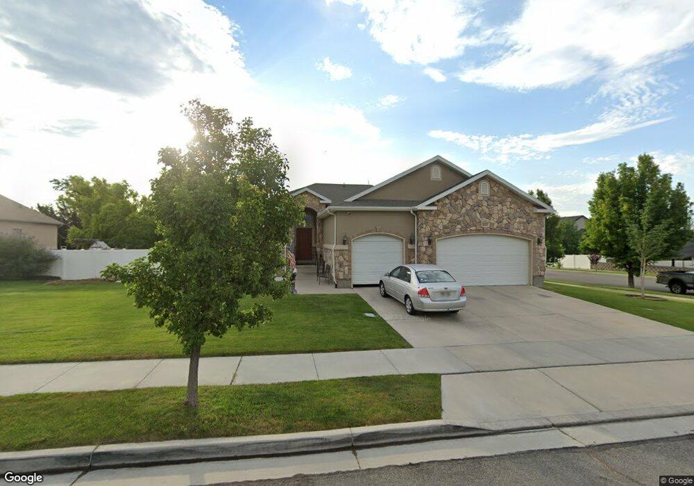
12517 Andreas St Riverton, UT 84096
Estimated Value: $638,000 - $686,000
3
Beds
2
Baths
1,682
Sq Ft
$393/Sq Ft
Est. Value
About This Home
This home is located at 12517 Andreas St, Riverton, UT 84096 and is currently estimated at $661,071, approximately $393 per square foot. 12517 Andreas St is a home located in Salt Lake County with nearby schools including Midas Creek Elementary School, Oquirrh Hills Middle School, and Riverton High School.
Ownership History
Date
Name
Owned For
Owner Type
Purchase Details
Closed on
Aug 19, 2005
Sold by
D R Horton Inc
Bought by
Mcdonald Edward and Mcdonald Judith O
Current Estimated Value
Home Financials for this Owner
Home Financials are based on the most recent Mortgage that was taken out on this home.
Original Mortgage
$201,950
Outstanding Balance
$105,404
Interest Rate
5.56%
Mortgage Type
Fannie Mae Freddie Mac
Estimated Equity
$555,667
Create a Home Valuation Report for This Property
The Home Valuation Report is an in-depth analysis detailing your home's value as well as a comparison with similar homes in the area
Home Values in the Area
Average Home Value in this Area
Purchase History
| Date | Buyer | Sale Price | Title Company |
|---|---|---|---|
| Mcdonald Edward | -- | Surety Title |
Source: Public Records
Mortgage History
| Date | Status | Borrower | Loan Amount |
|---|---|---|---|
| Open | Mcdonald Edward | $201,950 |
Source: Public Records
Tax History Compared to Growth
Tax History
| Year | Tax Paid | Tax Assessment Tax Assessment Total Assessment is a certain percentage of the fair market value that is determined by local assessors to be the total taxable value of land and additions on the property. | Land | Improvement |
|---|---|---|---|---|
| 2025 | $3,427 | $621,400 | $232,000 | $389,400 |
| 2024 | $3,427 | $593,200 | $221,400 | $371,800 |
| 2023 | $3,547 | $578,800 | $250,600 | $328,200 |
| 2022 | $3,698 | $591,900 | $245,700 | $346,200 |
| 2021 | $3,205 | $456,700 | $192,600 | $264,100 |
| 2020 | $2,938 | $390,400 | $192,600 | $197,800 |
| 2019 | $2,875 | $375,600 | $192,600 | $183,000 |
| 2018 | $2,774 | $356,800 | $167,300 | $189,500 |
| 2017 | $2,808 | $352,000 | $167,300 | $184,700 |
| 2016 | $2,691 | $323,600 | $129,700 | $193,900 |
| 2015 | $2,786 | $324,800 | $138,300 | $186,500 |
| 2014 | $2,485 | $284,100 | $122,200 | $161,900 |
Source: Public Records
Map
Nearby Homes
- 12501 S Huron Rd
- 4494 W Osage Rd
- 12644 S Quail Lake Dr
- 12339 Black Foot St
- 4587 W Flintlock Way
- 12737 S Quail Lake Dr
- 4243 W Park Lake Ct
- 4212 W Flight Park Ct
- 12284 S Flintlock Way
- 12159 Swensen Cir
- 4768 W Liberation Dr
- 12363 Stockade Ln
- 4219 W Millsite Park Ct
- 12693 S Lincoln Peak Ln
- 12687 S Lincoln Peak Ln Unit 126
- 12687 S Lincoln Peak Ln
- 12694 S Lincoln Peak Ln Unit 116
- 12694 S Lincoln Peak Ln
- 12688 S Lincoln Peak Ln Unit 115
- 12688 S Lincoln Peak Ln
- 12503 Andreas St
- 12503 S Andreas St
- 4388 W Harvest Creek Way
- 4388 Harvest Creek Way
- 12543 Andreas St
- 12543 S Andreas St
- 12522 Andreas St
- 12512 Andreas St
- 12512 S Andreas St
- 12487 Andreas St
- 12487 S Andreas St
- 12532 S Andreas St
- 12532 Andreas St
- 12502 Andreas St
- 12502 S Andreas St
- 4383 Sacajewa St
- 4372 Harvest Creek Way
- 4389 W Harvest Creek Way Unit 11
- 4389 W Harvest Creek Way
- 12542 S Andreas St