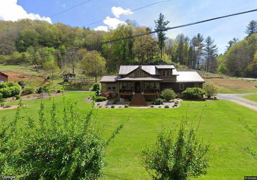
1252 White Pine Rd Newland, NC 28657
Estimated Value: $330,000 - $644,000
3
Beds
3
Baths
2,372
Sq Ft
$206/Sq Ft
Est. Value
About This Home
This home is located at 1252 White Pine Rd, Newland, NC 28657 and is currently estimated at $487,790, approximately $205 per square foot. 1252 White Pine Rd is a home located in Avery County with nearby schools including Crossnore Elementary School, Avery Middle School, and Avery County High School.
Ownership History
Date
Name
Owned For
Owner Type
Purchase Details
Closed on
Mar 10, 2010
Sold by
Phillips Richard and Phillips Janice
Bought by
Clark Nathan A and Clark Crystal D
Current Estimated Value
Home Financials for this Owner
Home Financials are based on the most recent Mortgage that was taken out on this home.
Original Mortgage
$134,000
Outstanding Balance
$88,768
Interest Rate
4.97%
Mortgage Type
New Conventional
Estimated Equity
$399,022
Create a Home Valuation Report for This Property
The Home Valuation Report is an in-depth analysis detailing your home's value as well as a comparison with similar homes in the area
Home Values in the Area
Average Home Value in this Area
Purchase History
| Date | Buyer | Sale Price | Title Company |
|---|---|---|---|
| Clark Nathan A | $200,000 | None Available |
Source: Public Records
Mortgage History
| Date | Status | Borrower | Loan Amount |
|---|---|---|---|
| Open | Clark Nathan A | $134,000 |
Source: Public Records
Tax History Compared to Growth
Tax History
| Year | Tax Paid | Tax Assessment Tax Assessment Total Assessment is a certain percentage of the fair market value that is determined by local assessors to be the total taxable value of land and additions on the property. | Land | Improvement |
|---|---|---|---|---|
| 2024 | $1,207 | $301,300 | $65,000 | $236,300 |
| 2023 | $1,207 | $301,300 | $65,000 | $236,300 |
| 2022 | $1,207 | $301,300 | $65,000 | $236,300 |
| 2021 | $1,193 | $216,600 | $45,300 | $171,300 |
| 2020 | $1,193 | $216,600 | $45,300 | $171,300 |
| 2019 | $1,191 | $216,600 | $45,300 | $171,300 |
| 2018 | $1,044 | $189,900 | $45,300 | $144,600 |
| 2017 | $1,049 | $190,700 | $0 | $0 |
| 2016 | $853 | $190,700 | $0 | $0 |
| 2015 | $853 | $190,700 | $34,500 | $156,200 |
| 2012 | -- | $199,200 | $39,800 | $159,400 |
Source: Public Records
Map
Nearby Homes
- TBD Mount Mitchell Dr Unit Lot 39
- 365 Trout Brook Loop
- 134 Goldfinch Rd
- 439 Locust Rd
- 25 Poke Rd
- 120 Ridge Rd
- 478 Laurel Hills Rd
- 136 Ivy Rd
- 42 Ivy Rd
- 164 Rocky Meadows Rd
- 140 Ash Loop
- 175 Ash Loop
- 14 Briar Rd
- Lot 20 Jewel Weed Trail
- Tbd Cow Camp Rd
- 33 Summit Ln
- 476 Locust Rd
- 335 Snowshoe Loop
- 6 Ridgewood Ln
- 20 Twintree Ln
- 1164 White Pine Rd
- 1160 White Pine Rd
- 1365 White Pine Rd
- 230 Walt Clark Rd
- 1450 White Pine Rd
- 200 Walt Clark Rd
- 1437 White Pine Rd
- 1451 White Pine Rd
- 256 Walt Clark Rd
- 1199 White Pine Rd
- 106 Stephen Charles Ln
- 1500 White Pine Rd
- 1460 White Pine Rd
- 294 Walt Clark Rd
- 747 Michelle Ln
- 732 Michelle Ln
- 986 White Pine Rd
- 61 Honky Hollow Ln
- 700 Michelle Ln
- 1603 White Pine Rd