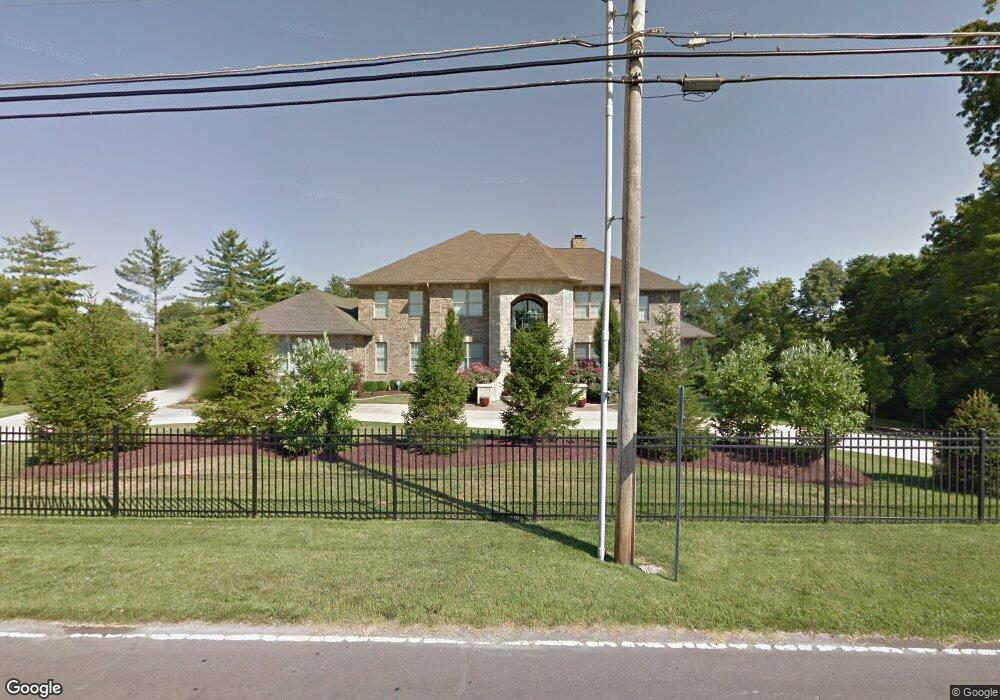
12529 W Watson Rd Saint Louis, MO 63127
Estimated Value: $1,176,000 - $1,868,060
6
Beds
6
Baths
6,984
Sq Ft
$208/Sq Ft
Est. Value
About This Home
This home is located at 12529 W Watson Rd, Saint Louis, MO 63127 and is currently estimated at $1,455,515, approximately $208 per square foot. 12529 W Watson Rd is a home located in St. Louis County with nearby schools including Crestwood Elementary School, Truman Middle School, and Lindbergh High School.
Ownership History
Date
Name
Owned For
Owner Type
Purchase Details
Closed on
Aug 30, 2006
Sold by
T Bills Properties Llc
Bought by
Anic Bernard and Anic Patricia
Current Estimated Value
Home Financials for this Owner
Home Financials are based on the most recent Mortgage that was taken out on this home.
Original Mortgage
$1,115,000
Outstanding Balance
$667,973
Interest Rate
6.72%
Mortgage Type
Purchase Money Mortgage
Estimated Equity
$787,542
Purchase Details
Closed on
Jun 4, 2001
Sold by
Maher Guy H and Maher Helen M
Bought by
T Bill Properties Llc
Home Financials for this Owner
Home Financials are based on the most recent Mortgage that was taken out on this home.
Original Mortgage
$161,250
Interest Rate
7.1%
Create a Home Valuation Report for This Property
The Home Valuation Report is an in-depth analysis detailing your home's value as well as a comparison with similar homes in the area
Home Values in the Area
Average Home Value in this Area
Purchase History
| Date | Buyer | Sale Price | Title Company |
|---|---|---|---|
| Anic Bernard | $315,000 | None Available | |
| T Bill Properties Llc | $215,000 | -- | |
| T Bill Properties Llc | -- | -- |
Source: Public Records
Mortgage History
| Date | Status | Borrower | Loan Amount |
|---|---|---|---|
| Open | Anic Bernard | $1,115,000 | |
| Previous Owner | T Bill Properties Llc | $161,250 | |
| Closed | T Bill Properties Llc | $100,000 |
Source: Public Records
Tax History Compared to Growth
Tax History
| Year | Tax Paid | Tax Assessment Tax Assessment Total Assessment is a certain percentage of the fair market value that is determined by local assessors to be the total taxable value of land and additions on the property. | Land | Improvement |
|---|---|---|---|---|
| 2025 | $17,762 | $303,510 | $43,700 | $259,810 |
| 2024 | $17,762 | $248,390 | $33,250 | $215,140 |
| 2023 | $17,723 | $248,390 | $33,250 | $215,140 |
| 2022 | $16,470 | $222,020 | $34,850 | $187,170 |
| 2021 | $16,388 | $222,020 | $34,850 | $187,170 |
| 2020 | $16,583 | $216,890 | $27,610 | $189,280 |
| 2019 | $16,539 | $216,890 | $27,610 | $189,280 |
| 2018 | $20,605 | $252,620 | $14,610 | $238,010 |
| 2017 | $20,385 | $252,620 | $14,610 | $238,010 |
| 2016 | $15,001 | $186,030 | $14,610 | $171,420 |
| 2015 | $14,801 | $186,030 | $14,610 | $171,420 |
| 2014 | $9,529 | $118,070 | $8,910 | $109,160 |
Source: Public Records
Map
Nearby Homes
- 21 Black Oak Dr
- 12420 Rott Rd Unit 1B
- 3906 Courtyard Place Dr
- 12685 Alberts Laumeier Ct
- 9129 Rott Rd
- 10225 E Watson Rd
- 12110 Trentmore Place
- 12981 Baalbek Dr
- 228 Deane Ct
- 118 Monica Dr
- 12795 Nanell Ln
- 119 Monica Dr
- 9302 Caddyshack Cir
- 1412 Windward Ridge Dr
- 401 Rayburn Ave
- 405 Rayburn Ave
- 8948 Crest Oak Ln
- 421 Spears St
- 301 Memphis St
- 1 Boxwood Ln
- 9060 Middlewood Ct
- 12507 W Watson Rd
- 12602 Bradford Woods Dr
- 12608 Bradford Woods Dr
- 12461 W Watson Rd
- 12614 Bradford Woods Dr
- 9054 Middlewood Ct
- 9063 Middlewood Ct
- 12551 W Watson Rd
- 12600 W Watson Rd
- 12455 W Watson Rd
- 12626 Bradford Woods Dr
- 9048 Middlewood Ct
- 12621 Bradford Woods Dr
- 12552 W Watson Rd
- 9049 Middlewood Ct
- 12443 W Watson Rd
- 12603 W Watson Rd
- 12610 W Watson Rd
- 12632 Bradford Woods Dr