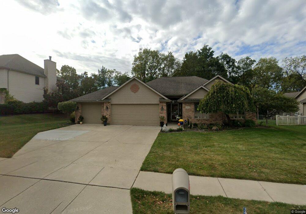
1253 Ryan Ct Springfield, OH 45503
Estimated Value: $331,000 - $388,000
3
Beds
2
Baths
1,591
Sq Ft
$226/Sq Ft
Est. Value
About This Home
This home is located at 1253 Ryan Ct, Springfield, OH 45503 and is currently estimated at $359,863, approximately $226 per square foot. 1253 Ryan Ct is a home located in Clark County with nearby schools including Northridge Elementary School, Kenton Ridge Middle & High School, and Emmanuel Christian Academy.
Ownership History
Date
Name
Owned For
Owner Type
Purchase Details
Closed on
Apr 3, 2025
Sold by
Little Douglas B and Little Diana M
Bought by
Lord Michelle B
Current Estimated Value
Home Financials for this Owner
Home Financials are based on the most recent Mortgage that was taken out on this home.
Original Mortgage
$239,900
Outstanding Balance
$237,567
Interest Rate
6.76%
Mortgage Type
New Conventional
Estimated Equity
$122,296
Purchase Details
Closed on
Oct 4, 2000
Sold by
Sims Catherine A and Myser Lacretia A
Bought by
Little John W and Little Barbara A
Purchase Details
Closed on
Sep 24, 1999
Sold by
Hunt Mable L
Bought by
Hunt Mable L
Purchase Details
Closed on
Jul 1, 1994
Sold by
Kingsgate Commons Ptns
Bought by
Hunt Mable L
Create a Home Valuation Report for This Property
The Home Valuation Report is an in-depth analysis detailing your home's value as well as a comparison with similar homes in the area
Home Values in the Area
Average Home Value in this Area
Purchase History
| Date | Buyer | Sale Price | Title Company |
|---|---|---|---|
| Lord Michelle B | $349,900 | City Title | |
| Lord Michelle B | $349,900 | City Title | |
| Little John W | $169,900 | -- | |
| Hunt Mable L | -- | -- | |
| Hunt Mable L | $30,500 | -- |
Source: Public Records
Mortgage History
| Date | Status | Borrower | Loan Amount |
|---|---|---|---|
| Open | Lord Michelle B | $239,900 | |
| Closed | Lord Michelle B | $239,900 |
Source: Public Records
Tax History
| Year | Tax Paid | Tax Assessment Tax Assessment Total Assessment is a certain percentage of the fair market value that is determined by local assessors to be the total taxable value of land and additions on the property. | Land | Improvement |
|---|---|---|---|---|
| 2025 | $2,739 | $92,780 | $25,430 | $67,350 |
| 2024 | $2,672 | $74,370 | $21,300 | $53,070 |
| 2023 | $2,672 | $74,370 | $21,300 | $53,070 |
| 2022 | $2,699 | $74,370 | $21,300 | $53,070 |
| 2021 | $2,474 | $60,350 | $16,510 | $43,840 |
| 2020 | $2,476 | $60,350 | $16,510 | $43,840 |
| 2019 | $2,469 | $59,180 | $16,510 | $42,670 |
| 2018 | $2,535 | $58,750 | $16,890 | $41,860 |
| 2017 | $2,155 | $55,826 | $16,895 | $38,931 |
| 2016 | $2,139 | $55,826 | $16,895 | $38,931 |
| 2015 | $2,330 | $55,633 | $17,784 | $37,849 |
| 2014 | $2,329 | $55,633 | $17,784 | $37,849 |
| 2013 | $2,324 | $55,633 | $17,784 | $37,849 |
Source: Public Records
Map
Nearby Homes
- 1201 Kingsgate Rd
- 3052 Brixton Dr E
- 1136 Foxboro Rd Unit 202
- 3631 Kingsgate Ln
- 1500 Kingsgate Rd Unit 19430
- 1502 Kingsgate Rd Unit 19432
- 1500 Kingsgate Rd
- 1502 Kingsgate Rd
- 1139 Bradford Dr
- 1503 Kingsgate Rd
- 1505 Kingsgate Rd
- 1507 Kingsgate Rd
- 1039 Bradford Dr Unit 42
- 1415 Montego Dr
- 1811 Saint Andrews Ct
- 1644 Delmar Dr
- 3211 Haverhill St
- 1922 Wedgewood Cir
- 2022 Westboro Ave
- 3126 Lakeview Ct Unit 3126
Your Personal Tour Guide
Ask me questions while you tour the home.