
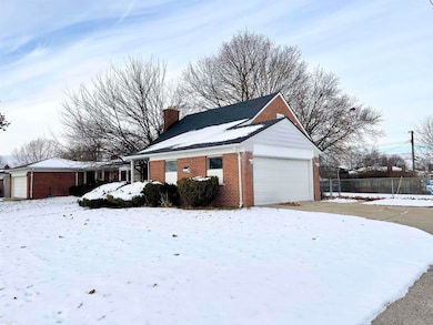
12531 Common Rd Warren, MI 48093
Northeast Warren NeighborhoodEstimated payment $1,562/month
Highlights
- Deck
- Fenced Yard
- 2 Car Attached Garage
- Main Floor Bedroom
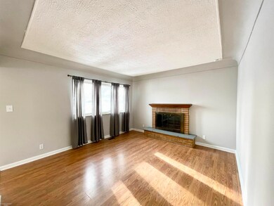
- Fireplace
- Living Room
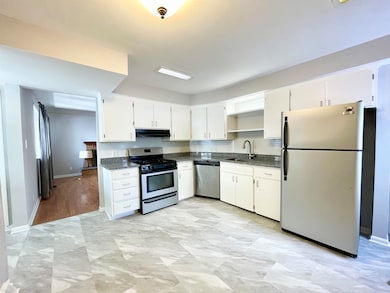
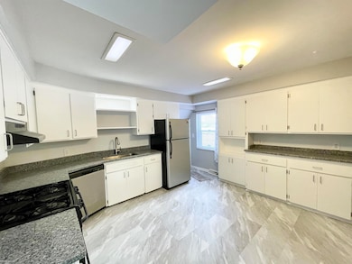
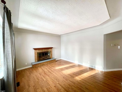
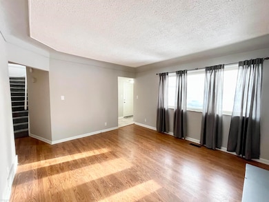
About This Home
Check out this unique Warren Bungalow located in Warren Con. Schools! Spacious Kitchen gives you plenty of room to cook, cozy Living Room with fireplace for the upcoming cold, two main floor bedrooms, and a nicely sized bedroom / sitting area (or office space) upstairs with additional full bath! Open basement is ready for finishing, or for use as storage.
Listing Agent
Berkshire Hathaway HomeServices Kee Realty SCS License #MISPE-6506045071 Listed on: 12/05/2025

Home Details
Home Type
- Single Family
Est. Annual Taxes
Year Built
- Built in 1957
Lot Details
- 10,454 Sq Ft Lot
- Lot Dimensions are 84 x 124
- Fenced Yard
Parking
- 2 Car Attached Garage
Home Design
- Bungalow
- Brick Exterior Construction
Interior Spaces
- 1,170 Sq Ft Home
- 1.5-Story Property
- Fireplace
- Living Room
- Dishwasher
Bedrooms and Bathrooms
- 2 Bedrooms
- Main Floor Bedroom
- Bathroom on Main Level
- 2 Full Bathrooms
Basement
- Basement Fills Entire Space Under The House
- Block Basement Construction
Outdoor Features
- Deck
Utilities
- Forced Air Heating System
- Heating System Uses Natural Gas
- Gas Water Heater
Community Details
- Fairlane Estates Sub Subdivision
Listing and Financial Details
- Assessor Parcel Number 12-13-11-179-040
Map
Home Values in the Area
Average Home Value in this Area
Tax History
| Year | Tax Paid | Tax Assessment Tax Assessment Total Assessment is a certain percentage of the fair market value that is determined by local assessors to be the total taxable value of land and additions on the property. | Land | Improvement |
|---|---|---|---|---|
| 2025 | $3,682 | $103,540 | $0 | $0 |
| 2024 | $36 | $97,500 | $0 | $0 |
| 2023 | $3,376 | $83,130 | $0 | $0 |
| 2022 | $3,289 | $65,190 | $0 | $0 |
| 2021 | $4,054 | $60,350 | $0 | $0 |
| 2020 | $4,177 | $54,400 | $0 | $0 |
| 2019 | $2,977 | $51,040 | $0 | $0 |
| 2018 | $0 | $50,620 | $0 | $0 |
| 2017 | $2,920 | $48,390 | $14,360 | $34,030 |
| 2016 | $2,904 | $48,390 | $0 | $0 |
| 2015 | -- | $46,190 | $0 | $0 |
| 2013 | $2,725 | $41,800 | $0 | $0 |
Property History
| Date | Event | Price | List to Sale | Price per Sq Ft |
|---|---|---|---|---|
| 02/24/2026 02/24/26 | Pending | -- | -- | -- |
| 12/05/2025 12/05/25 | For Sale | $239,900 | -- | $205 / Sq Ft |
Purchase History
| Date | Type | Sale Price | Title Company |
|---|---|---|---|
| Interfamily Deed Transfer | -- | None Available | |
| Interfamily Deed Transfer | -- | None Available |
Mortgage History
| Date | Status | Loan Amount | Loan Type |
|---|---|---|---|
| Closed | $81,200 | New Conventional |
Source: Michigan Multiple Listing Service
MLS Number: 50195696
APN: 12-13-11-179-040
Disclaimer: Certain information contained herein is derived from information provided by parties other than Homes.com. All information provided is deemed reliable, but is not guaranteed to be accurate and should be independently verified.
![]() Source MLS: MiRealSource
Source MLS: MiRealSource
Provided through IDX via MiRealSource. Courtesy of MiRealSource Shareholder. Copyright MiRealSource.
The information published and disseminated by MiRealSource is communicated verbatim, without change by MiRealSource, as filed with MiRealSource by its members. The accuracy of all information, regardless of source, is not guaranteed or warranted. All information should be independently verified.
Copyright 2026 MiRealSource. All rights reserved. The information provided hereby constitutes proprietary information of MiRealSource, Inc. and its shareholders, affiliates and licensees and may not be reproduced or transmitted in any form or by any means, electronic or mechanical, including photocopy, recording, scanning or any information storage and retrieval system, without written permission from MiRealSource, Inc.
- 30045 Iroquois Dr
- 54765 Palomino Ave
- 30745 Iroquois Dr
- 29366 Wagner Dr
- 29337 Roan Dr
- 13325 Iowa Dr
- 30616 Mcgrath Dr
- 30955 Iroquois Dr
- 30806 Ridgefield Ave
- 30829 Eiffel Ave
- 29105 Palomino Dr
- 29368 Hoover Rd Unit A3
- 29460 Hoover Rd Unit D37
- 31036 Palomino Dr
- 29626 Hoover Rd Unit 626
- 29143 Dover Ave
- 29091 Wagner Dr
- 29451 Hoover Rd
- 29346 Hoover Rd
- 29248 Hoover Rd Unit 171
Ask me questions while you tour the home.