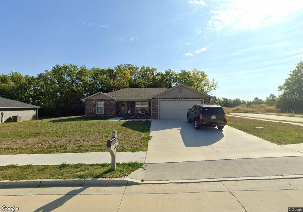
1256 Commons Dr Fulton, MO 65251
Estimated Value: $237,000 - $291,000
--
Bed
--
Bath
1,251
Sq Ft
$206/Sq Ft
Est. Value
About This Home
This home is located at 1256 Commons Dr, Fulton, MO 65251 and is currently estimated at $257,753, approximately $206 per square foot. 1256 Commons Dr is a home with nearby schools including Fulton Senior High School, Kingdom Christian Academy, and St. Peter Catholic School.
Ownership History
Date
Name
Owned For
Owner Type
Purchase Details
Closed on
Jan 29, 2021
Sold by
Joe Ellsworth Construction Llc
Bought by
Baker Charles and Baker Robyn
Current Estimated Value
Home Financials for this Owner
Home Financials are based on the most recent Mortgage that was taken out on this home.
Original Mortgage
$120,656
Outstanding Balance
$107,477
Interest Rate
2.6%
Mortgage Type
New Conventional
Estimated Equity
$150,276
Purchase Details
Closed on
Jul 10, 2020
Sold by
Cj Property Llc
Bought by
Joe Ellsworth Const Llc
Create a Home Valuation Report for This Property
The Home Valuation Report is an in-depth analysis detailing your home's value as well as a comparison with similar homes in the area
Home Values in the Area
Average Home Value in this Area
Purchase History
| Date | Buyer | Sale Price | Title Company |
|---|---|---|---|
| Baker Charles | -- | None Listed On Document | |
| Baker Charles | -- | None Listed On Document | |
| Joe Ellsworth Const Llc | -- | None Available |
Source: Public Records
Mortgage History
| Date | Status | Borrower | Loan Amount |
|---|---|---|---|
| Open | Baker Charles | $120,656 | |
| Closed | Baker Charles | $120,656 |
Source: Public Records
Tax History Compared to Growth
Tax History
| Year | Tax Paid | Tax Assessment Tax Assessment Total Assessment is a certain percentage of the fair market value that is determined by local assessors to be the total taxable value of land and additions on the property. | Land | Improvement |
|---|---|---|---|---|
| 2024 | $2,037 | $32,963 | $0 | $0 |
| 2023 | $2,039 | $5,700 | $0 | $0 |
| 2022 | $351 | $32,488 | $5,700 | $26,788 |
| 2021 | $220 | $3,582 | $3,582 | $0 |
| 2020 | $383 | $6,137 | $6,137 | $0 |
| 2019 | $370 | $6,137 | $6,137 | $0 |
Source: Public Records
Map
Nearby Homes
- 528 Kinleigh Dr
- 537 Kinleigh Dr
- 3.69 ACRES Tennyson Rd
- 1311 Cote Sans Dessein Rd
- 509 S Business 54
- 1400 Marbrooke Dr
- 0 Callaway Dr
- 250 Tennyson Rd
- 106 Schultze St
- 1205 Parkridge Dr
- 6309 Shale Ct
- 1950 S Business 54
- 2946 Missouri F
- 308 E 6th St
- 710 Hollyhock Dr
- 5084 Red Maple Ln Unit 5084
- 703 Bluff St
- 801 Court St
- TBD Route O
- 0
- 1244 Addalyn Dr
- 1252 Addalyn Dr
- 1291 Commons Loop
- 1297 Commons Loop Ln
- 1224 Addalyn Dr
- 1301 Commons Loop Ln
- 1300 Commons Loop Ln
- 1220 Addalyn Dr
- 491 Commons Dr
- 1305 Commons Loop Ln
- 1304 Commons Loop Ln
- 220 Collier Ln
- 503 Commons Dr
- 1240 Addalyn Dr
- 1232 Addalyn Dr
- 1243 Addalyn Dr
- 1239 Addalyn Dr
- 1308 Commons Loop Ln
- 1306 Preston Dr
- 1311 Commons Loop Ln