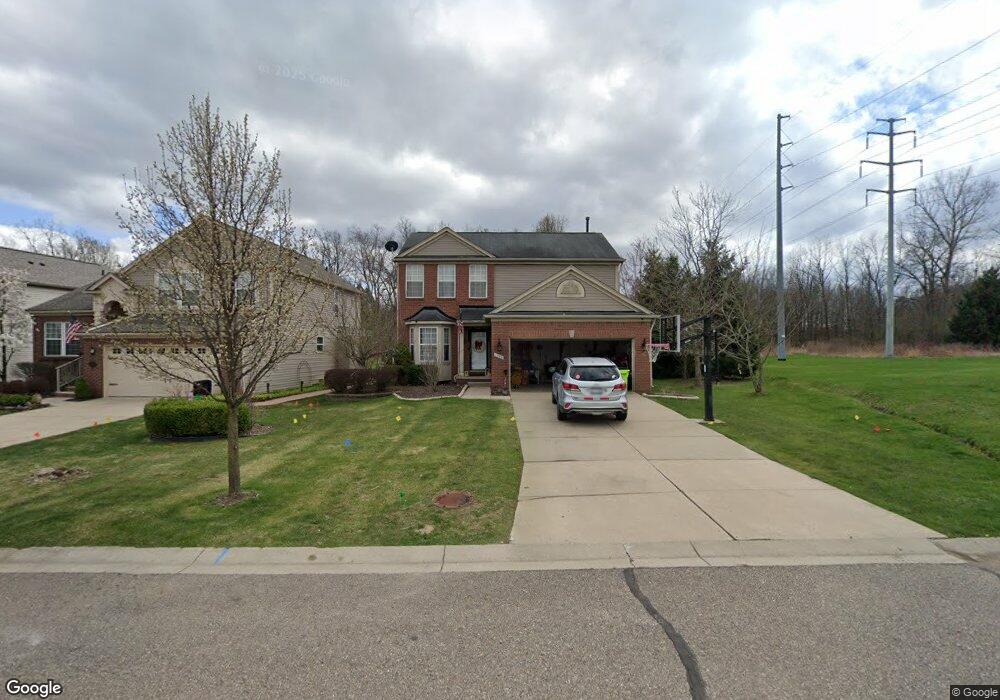
1259 Callaway Ct Unit 27 Howell, MI 48843
Estimated Value: $377,000 - $399,000
4
Beds
3
Baths
1,799
Sq Ft
$215/Sq Ft
Est. Value
About This Home
This home is located at 1259 Callaway Ct Unit 27, Howell, MI 48843 and is currently estimated at $387,570, approximately $215 per square foot. 1259 Callaway Ct Unit 27 is a home located in Livingston County with nearby schools including Ruahmah J. Hutchings Elementary, Parker Middle School, and Howell High School.
Ownership History
Date
Name
Owned For
Owner Type
Purchase Details
Closed on
Jun 4, 2004
Sold by
Pulte Land Co Llc
Bought by
Barra Lindsay and Derocher Matthew R
Current Estimated Value
Create a Home Valuation Report for This Property
The Home Valuation Report is an in-depth analysis detailing your home's value as well as a comparison with similar homes in the area
Home Values in the Area
Average Home Value in this Area
Purchase History
| Date | Buyer | Sale Price | Title Company |
|---|---|---|---|
| Barra Lindsay | $68,000 | Metropolitan Title Company |
Source: Public Records
Tax History Compared to Growth
Tax History
| Year | Tax Paid | Tax Assessment Tax Assessment Total Assessment is a certain percentage of the fair market value that is determined by local assessors to be the total taxable value of land and additions on the property. | Land | Improvement |
|---|---|---|---|---|
| 2025 | $2,404 | $185,200 | $0 | $0 |
| 2024 | $2,335 | $170,100 | $0 | $0 |
| 2023 | $2,231 | $152,500 | $0 | $0 |
| 2022 | $1,026 | $129,300 | $0 | $0 |
| 2021 | $3,144 | $134,300 | $0 | $0 |
| 2020 | $3,937 | $129,300 | $0 | $0 |
| 2019 | $4,223 | $120,700 | $0 | $0 |
| 2018 | $4,174 | $112,500 | $0 | $0 |
| 2017 | $5,014 | $109,800 | $0 | $0 |
| 2016 | $4,118 | $104,100 | $0 | $0 |
| 2014 | $2,480 | $90,500 | $0 | $0 |
| 2012 | $2,480 | $82,700 | $0 | $0 |
Source: Public Records
Map
Nearby Homes
- 3991 Rainier Dr Unit 1
- 636 Zion Ct
- 4059 Ash Tree Ln
- 1815 Gulley Rd
- 32 N Latson Rd
- 571 Cannonade Loop
- 523 Cannonade Loop
- 583 Cannonade Loop
- The Austin Plan at Broadmoor
- The Charlotte Plan at Broadmoor
- The Harrison Plan at Broadmoor
- The Bloomington Plan at Broadmoor
- The Columbia Plan at Broadmoor
- 475 Cannonade Loop
- 559 Cannonade Loop
- 3227 Waverly Woods Ln
- 3224 Waverly Woods Ln
- 3040 Bogues View Dr
- 3020 Brookline
- 1633 Frech Ln
- 1253 Callaway Ct Unit 28
- 1247 Callaway Ct Unit 29
- 1241 Callaway Ct
- 1260 Callaway Ct Unit 141
- 1254 Callaway Ct Unit 140
- 1235 Callaway Ct Unit 31
- 0 McGunn Rd
- 1248 Callaway Ct Unit 139
- 1283 Callaway Ct
- 1240 Callaway Ct Unit 138
- 1229 Callaway Ct Unit 32
- 1289 Callaway Ct
- 1223 Callaway Ct Unit 33
- 1025 Walcott Ln Unit 137
- 1288 Callaway Ct Unit 143
- 4312 McGunn Rd
- 1217 Callaway Ct Unit 34
- 1033 Walcott Ln
- 1224 Callaway Ct Unit 126
- 1295 Callaway Ct Unit 24