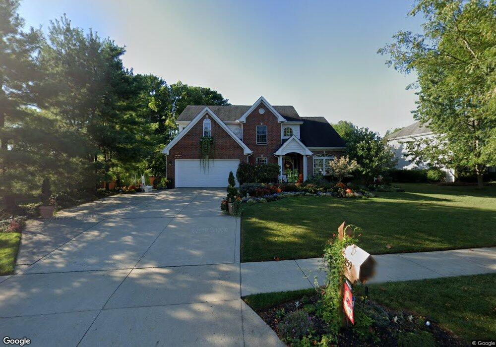
1259 Sea Shell Dr Westerville, OH 43082
Genoa NeighborhoodEstimated Value: $590,696 - $620,000
3
Beds
3
Baths
2,845
Sq Ft
$214/Sq Ft
Est. Value
About This Home
This home is located at 1259 Sea Shell Dr, Westerville, OH 43082 and is currently estimated at $609,174, approximately $214 per square foot. 1259 Sea Shell Dr is a home located in Delaware County with nearby schools including Robert Frost Elementary School, Heritage Middle School, and Westerville-North High School.
Ownership History
Date
Name
Owned For
Owner Type
Purchase Details
Closed on
Aug 31, 2023
Sold by
Hollar Ronald M and Hollar Deborah M
Bought by
Hollar Family Trust and Hollar
Current Estimated Value
Purchase Details
Closed on
Mar 16, 2000
Sold by
Wyndfield Ltd Inc
Bought by
Hollar Ronald M and Hollar Deborah M
Home Financials for this Owner
Home Financials are based on the most recent Mortgage that was taken out on this home.
Original Mortgage
$135,000
Interest Rate
7.5%
Mortgage Type
New Conventional
Create a Home Valuation Report for This Property
The Home Valuation Report is an in-depth analysis detailing your home's value as well as a comparison with similar homes in the area
Home Values in the Area
Average Home Value in this Area
Purchase History
| Date | Buyer | Sale Price | Title Company |
|---|---|---|---|
| Hollar Family Trust | -- | None Listed On Document | |
| Hollar Ronald M | $260,578 | -- |
Source: Public Records
Mortgage History
| Date | Status | Borrower | Loan Amount |
|---|---|---|---|
| Previous Owner | Hollar Ronald M | $135,000 |
Source: Public Records
Tax History Compared to Growth
Tax History
| Year | Tax Paid | Tax Assessment Tax Assessment Total Assessment is a certain percentage of the fair market value that is determined by local assessors to be the total taxable value of land and additions on the property. | Land | Improvement |
|---|---|---|---|---|
| 2024 | $8,449 | $165,830 | $36,050 | $129,780 |
| 2023 | $8,352 | $165,830 | $36,050 | $129,780 |
| 2022 | $8,011 | $123,060 | $22,750 | $100,310 |
| 2021 | $8,080 | $123,060 | $22,750 | $100,310 |
| 2020 | $8,133 | $123,060 | $22,750 | $100,310 |
| 2019 | $7,456 | $107,770 | $22,750 | $85,020 |
| 2018 | $7,330 | $107,770 | $22,750 | $85,020 |
| 2017 | $7,272 | $104,480 | $19,950 | $84,530 |
| 2016 | $7,753 | $104,480 | $19,950 | $84,530 |
| 2015 | $7,417 | $104,480 | $19,950 | $84,530 |
| 2014 | $7,491 | $104,480 | $19,950 | $84,530 |
| 2013 | $7,260 | $101,220 | $19,950 | $81,270 |
Source: Public Records
Map
Nearby Homes
- 1155 Ashford Ct
- 7568 Park Bend Ct
- 9119 Robinhood Cir
- 6618 Wild Rose Ln
- 6611 Lake of the Woods Point
- 9200 Knoll Dr
- 974 Lakeland Dr
- 6460 Bromfield Dr
- 8369 Manitou Dr
- 6685 Tussic Street Rd
- 73 Keethler Dr S
- 7663 Rolling Ridge Way
- 912 Lakeway Ct E
- 656 Olde Mill Dr
- 718 Sugar Ct
- 4485 Smothers Rd
- 754 Kingsmead Rd Unit 18754
- 6999 Red Bank Rd
- 5840 Heron Ct
- 5547 Red Bank Rd Unit Tract B
- 1228 Buoy Ct
- 1237 Sea Shell Dr
- 1266 Sea Shell Dr
- 1252 Sea Shell Dr
- 1231 Buoy Ct
- 7200 Sunbury Rd
- 7184 Sunbury Rd
- 1244 Sea Shell Dr
- 1227 Sea Shell Dr
- 1225 Sea Shell Dr
- 7250 Sunbury Rd
- 1227 Buoy Ct
- 7124 Sunbury Rd
- 664 Sea Shell Ct
- 1232 Sea Shell Dr
- 7185 Sunbury Rd
- 1221 Buoy Ct
- 672 Sea Shell Ct
- 1228 Sea Shell Dr
- 7286 Sunbury Rd