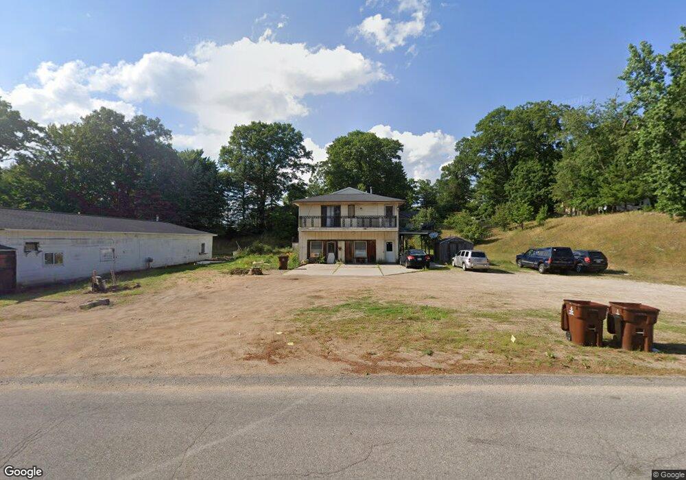
12594 Mcmanus St Sand Lake, MI 49343
Estimated Value: $173,000 - $232,567
--
Bed
--
Bath
1,500
Sq Ft
$131/Sq Ft
Est. Value
About This Home
This home is located at 12594 Mcmanus St, Sand Lake, MI 49343 and is currently estimated at $196,142, approximately $130 per square foot. 12594 Mcmanus St is a home located in Kent County with nearby schools including Cedar Trails Elementary School, Red Hawk Intermediate School, and Beach Elementary School.
Ownership History
Date
Name
Owned For
Owner Type
Purchase Details
Closed on
May 16, 2025
Sold by
Amato Giuseppe
Bought by
Cintek 2 Properties Llc
Current Estimated Value
Purchase Details
Closed on
May 23, 2024
Sold by
Amato Giuseppe
Bought by
Amato Giuseppe and Alpers Josephina
Purchase Details
Closed on
Apr 9, 2024
Sold by
Amato Giuseppe and Amato Anna Marie
Bought by
Amato Giuseppe
Purchase Details
Closed on
Sep 2, 2021
Sold by
Marie Amato and Marie Anna
Bought by
Amato Giuseppe and Amato Giuseppe
Create a Home Valuation Report for This Property
The Home Valuation Report is an in-depth analysis detailing your home's value as well as a comparison with similar homes in the area
Home Values in the Area
Average Home Value in this Area
Purchase History
| Date | Buyer | Sale Price | Title Company |
|---|---|---|---|
| Cintek 2 Properties Llc | $175,000 | None Listed On Document | |
| Amato Giuseppe | -- | None Listed On Document | |
| Amato Giuseppe | -- | None Listed On Document | |
| Amato Giuseppe | -- | None Listed On Document |
Source: Public Records
Tax History Compared to Growth
Tax History
| Year | Tax Paid | Tax Assessment Tax Assessment Total Assessment is a certain percentage of the fair market value that is determined by local assessors to be the total taxable value of land and additions on the property. | Land | Improvement |
|---|---|---|---|---|
| 2025 | $2,876 | $108,100 | $0 | $0 |
| 2024 | $2,876 | $113,500 | $0 | $0 |
| 2023 | $2,746 | $103,500 | $0 | $0 |
| 2022 | $3,085 | $99,400 | $0 | $0 |
| 2021 | $3,084 | $74,200 | $0 | $0 |
| 2020 | $2,601 | $83,500 | $0 | $0 |
| 2019 | $2,993 | $75,300 | $0 | $0 |
| 2018 | $2,934 | $59,500 | $0 | $0 |
| 2017 | $2,863 | $0 | $0 | $0 |
Source: Public Records
Map
Nearby Homes
- 12513 Mcmurty Dr NE
- 12432 Mcmurty Dr NE
- 12651 Maston Lake Dr
- 16351 Black Lake Cove
- 13142 Spruce Ridge Dr NE
- 13020 Spruceridge Rd
- 15740 Grey Goose Dr
- 16000 Force Ave NE
- 12789 Wagner St NE
- 12468 22 Mile Rd NE
- 12785 Linway St NE
- 12783 Laketon St NE
- 16375 Bass Lake Ave NE
- 15494 Kimball Rd
- 11629 Crimson Creek Dr
- 13478 NE Windy Craig Dr
- 2456 Dane St
- 11550 W Sidney Rd
- 12808 Lincoln Lake Ave NE
- 11026 W Sidney Rd
- 12594 Mcmanus St NE
- 12594 Mcmanus
- 12587 Mcmanus St NE
- 12587 Mcmanus
- 12595 Maston Lake Rd
- 12562 Glorietta Dr
- 12500 Maston Lake Rd
- 12586 Maston Lake Rd
- 12586 Maston Lake Rd
- 12566 Glorietta Dr
- 12566 Glorietta Dr
- 12571 Maston Lake Rd
- 12599 Maston Lake Rd
- 12601 Glorietta Dr
- 12556 Glorietta Dr
- 12565 Glorietta Dr
- 12565 Glorietta Dr
- 12633 Mcmanus St
- 12629 Maston Lake Rd
- 12525 Glorietta Dr