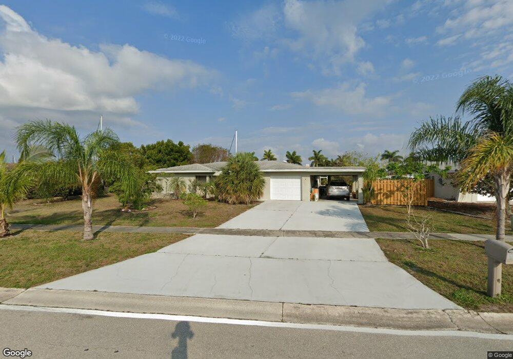
126 Cousley Dr SE Port Charlotte, FL 33952
Estimated Value: $417,000 - $512,000
3
Beds
2
Baths
1,768
Sq Ft
$254/Sq Ft
Est. Value
About This Home
This home is located at 126 Cousley Dr SE, Port Charlotte, FL 33952 and is currently estimated at $449,530, approximately $254 per square foot. 126 Cousley Dr SE is a home located in Charlotte County with nearby schools including Peace River Elementary School, Port Charlotte Middle School, and Charlotte High School.
Ownership History
Date
Name
Owned For
Owner Type
Purchase Details
Closed on
Nov 1, 2017
Sold by
Brown Ted E and Brown Pamela R
Bought by
Brown Ted W and Brown Pamela R
Current Estimated Value
Purchase Details
Closed on
Jan 30, 1998
Sold by
Lueddecke Hergbert H and Lueddecke Ursula A
Bought by
Brown Ted and Brown Pamela
Home Financials for this Owner
Home Financials are based on the most recent Mortgage that was taken out on this home.
Original Mortgage
$97,020
Outstanding Balance
$17,282
Interest Rate
7.07%
Estimated Equity
$432,248
Create a Home Valuation Report for This Property
The Home Valuation Report is an in-depth analysis detailing your home's value as well as a comparison with similar homes in the area
Home Values in the Area
Average Home Value in this Area
Purchase History
| Date | Buyer | Sale Price | Title Company |
|---|---|---|---|
| Brown Ted W | -- | Attorney | |
| Brown Ted | $138,600 | -- |
Source: Public Records
Mortgage History
| Date | Status | Borrower | Loan Amount |
|---|---|---|---|
| Open | Brown Ted | $97,020 |
Source: Public Records
Tax History Compared to Growth
Tax History
| Year | Tax Paid | Tax Assessment Tax Assessment Total Assessment is a certain percentage of the fair market value that is determined by local assessors to be the total taxable value of land and additions on the property. | Land | Improvement |
|---|---|---|---|---|
| 2024 | $3,553 | $218,997 | -- | -- |
| 2023 | $3,553 | $211,925 | $0 | $0 |
| 2022 | $3,443 | $206,425 | $0 | $0 |
| 2021 | $3,442 | $200,413 | $0 | $0 |
| 2020 | $3,385 | $197,646 | $0 | $0 |
| 2019 | $3,281 | $193,202 | $0 | $0 |
| 2018 | $3,042 | $189,600 | $110,500 | $79,100 |
| 2017 | $3,198 | $196,934 | $0 | $0 |
| 2016 | $3,184 | $192,883 | $0 | $0 |
| 2015 | $3,188 | $191,542 | $0 | $0 |
| 2014 | $3,157 | $190,022 | $0 | $0 |
Source: Public Records
Map
Nearby Homes
- 148 Peckham St SE
- 156 Morgan Ln SE
- 4400 Grassy Point Blvd
- 164 Morgan Ln SE Unit 412
- 150 Cousley Dr SE
- 171 Morgan Ln SE
- 138 Leland St SE
- 132 Peckham St SE
- 21452 Edgewater Dr
- 133 Peckham St SE
- 4471 Grassy Point Blvd
- 234 Fields Terrace SE
- 124 Leland St SE
- 21321 Harborside Blvd
- 138 Dowling Ave NE
- 124 Sinclair St SE
- 275 Stebbins Terrace SE
- 21370 Harborside Blvd
- 21444 Higgs Dr
- 21361 Harborside Blvd
- 124 Cousley Dr SE
- 128 Cousley Dr SE
- 125 Cousley Dr SE
- 130 Cousley Dr SE
- 122 Cousley Dr SE
- 129 Cousley Dr SE
- 152 Croop Ln SE
- 149 Peckham St SE
- 155 Croop Ln SE
- 120 Cousley Dr SE
- 132 Cousley Dr SE
- 119 Cousley Dr SE
- 156 Croop Ln SE
- 131 Cousley Dr SE
- 147 Peckham St SE
- 157 Croop Ln SE
- 140 Colonial St SE
- 118 Cousley Dr SE
- 115 Cousley Dr SE
- 138 Cousley Dr SE