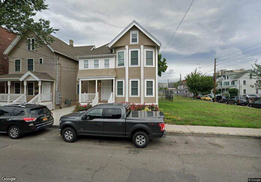
126 Henry St Stamford, CT 06902
Harbor Point NeighborhoodEstimated Value: $855,000 - $937,000
5
Beds
3
Baths
2,838
Sq Ft
$313/Sq Ft
Est. Value
About This Home
This home is located at 126 Henry St, Stamford, CT 06902 and is currently estimated at $887,459, approximately $312 per square foot. 126 Henry St is a home located in Fairfield County with nearby schools including Stillmeadow Elementary School, Rippowam Middle School, and Stamford High School.
Ownership History
Date
Name
Owned For
Owner Type
Purchase Details
Closed on
Jan 8, 2016
Sold by
Atlantic Ctr At Stamfo
Bought by
Henry Stamford Llc
Current Estimated Value
Purchase Details
Closed on
May 3, 2006
Sold by
Edwards Peggy L
Bought by
Odyssey Ventures Llc
Create a Home Valuation Report for This Property
The Home Valuation Report is an in-depth analysis detailing your home's value as well as a comparison with similar homes in the area
Home Values in the Area
Average Home Value in this Area
Purchase History
| Date | Buyer | Sale Price | Title Company |
|---|---|---|---|
| Henry Stamford Llc | -- | -- | |
| Henry Stamford Llc | -- | -- | |
| Odyssey Ventures Llc | $612,000 | -- | |
| Odyssey Ventures Llc | $612,000 | -- |
Source: Public Records
Mortgage History
| Date | Status | Borrower | Loan Amount |
|---|---|---|---|
| Previous Owner | Odyssey Ventures Llc | $345,000 | |
| Previous Owner | Odyssey Ventures Llc | $121,000 | |
| Previous Owner | Odyssey Ventures Llc | $120,000 |
Source: Public Records
Tax History Compared to Growth
Tax History
| Year | Tax Paid | Tax Assessment Tax Assessment Total Assessment is a certain percentage of the fair market value that is determined by local assessors to be the total taxable value of land and additions on the property. | Land | Improvement |
|---|---|---|---|---|
| 2025 | $8,849 | $369,940 | $137,840 | $232,100 |
| 2024 | $13,031 | $557,850 | $137,840 | $420,010 |
| 2023 | $14,080 | $557,850 | $137,840 | $420,010 |
| 2022 | $5,953 | $219,110 | $106,280 | $112,830 |
| 2021 | $6,019 | $223,410 | $106,280 | $117,130 |
| 2020 | $5,887 | $223,410 | $106,280 | $117,130 |
| 2019 | $5,887 | $223,410 | $106,280 | $117,130 |
| 2018 | $8,152 | $319,310 | $106,280 | $213,030 |
| 2017 | $5,893 | $219,150 | $63,920 | $155,230 |
| 2016 | $5,724 | $219,150 | $63,920 | $155,230 |
| 2015 | $5,573 | $219,150 | $63,920 | $155,230 |
| 2014 | $5,433 | $219,150 | $63,920 | $155,230 |
Source: Public Records
Map
Nearby Homes
- 56 Stone St
- 18 Brown Ave Unit 22
- 25 Brown Ave Unit 25
- 40 Orchard St
- 19 Stillwater Ave Unit E
- 79 Harbor Dr Unit 306
- 79 Harbor Dr Unit 320
- 102 Summer St Unit 2A
- 105 Harbor Dr Unit 117
- 105 Harbor Dr Unit 106
- 105 Harbor Dr Unit 107
- 127 Greyrock Place Unit 1112
- 98 Southfield Ave Unit 101
- 93 Spruce St Unit 11
- 1 Broad St Unit 19E
- 1 Broad St Unit 17C
- 1 Broad St Unit PH26E
- 8 Wardwell St Unit 6
- 17 Alden St
- 25 Forest St Unit 11M
- 130 Henry St
- 122 Henry St
- 79 Garden St
- 117 Henry St
- 748 Atlantic St
- 748 Atlantic St Unit 2
- 736 Atlantic St
- 736 Atlantic St Unit A
- 72 Garden St
- 72 Garden St Unit 3
- 756 Atlantic St
- 752 Atlantic St
- 68 Garden St
- 66 Garden St Unit 2
- 14 Woodland Ave
- 641 Pacific St
- 60 Garden St
- 60 Garden St Unit 4
- 6 Woodland Ave
- 753 Atlantic St