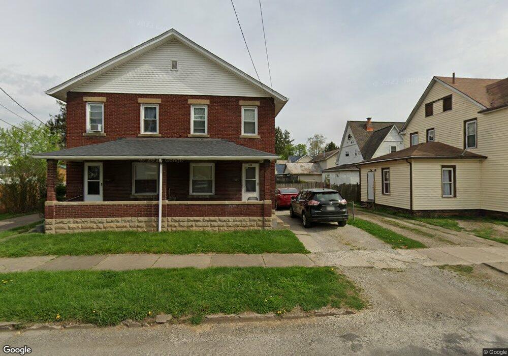
126 Hoover St Newark, OH 43055
Estimated Value: $182,000 - $205,000
6
Beds
2
Baths
2,560
Sq Ft
$76/Sq Ft
Est. Value
About This Home
This home is located at 126 Hoover St, Newark, OH 43055 and is currently estimated at $193,641, approximately $75 per square foot. 126 Hoover St is a home located in Licking County with nearby schools including John Clem Elementary School, Liberty Middle School, and Newark High School.
Ownership History
Date
Name
Owned For
Owner Type
Purchase Details
Closed on
Oct 24, 2005
Sold by
S & B Development Corp
Bought by
Ryan James and Ryan Deborah
Current Estimated Value
Purchase Details
Closed on
Oct 14, 1999
Sold by
Spurgeon Charles R
Bought by
Crawford William T
Home Financials for this Owner
Home Financials are based on the most recent Mortgage that was taken out on this home.
Original Mortgage
$65,200
Interest Rate
7.9%
Mortgage Type
New Conventional
Create a Home Valuation Report for This Property
The Home Valuation Report is an in-depth analysis detailing your home's value as well as a comparison with similar homes in the area
Home Values in the Area
Average Home Value in this Area
Purchase History
| Date | Buyer | Sale Price | Title Company |
|---|---|---|---|
| Ryan James | $90,000 | -- | |
| Crawford William T | $81,500 | -- |
Source: Public Records
Mortgage History
| Date | Status | Borrower | Loan Amount |
|---|---|---|---|
| Previous Owner | Crawford William T | $65,200 |
Source: Public Records
Tax History Compared to Growth
Tax History
| Year | Tax Paid | Tax Assessment Tax Assessment Total Assessment is a certain percentage of the fair market value that is determined by local assessors to be the total taxable value of land and additions on the property. | Land | Improvement |
|---|---|---|---|---|
| 2024 | $1,789 | $48,760 | $9,910 | $38,850 |
| 2023 | $2,598 | $48,760 | $9,910 | $38,850 |
| 2022 | $1,484 | $36,050 | $5,600 | $30,450 |
| 2021 | $1,557 | $36,050 | $5,600 | $30,450 |
| 2020 | $1,592 | $36,050 | $5,600 | $30,450 |
| 2019 | $1,289 | $28,080 | $4,660 | $23,420 |
| 2018 | $1,290 | $0 | $0 | $0 |
| 2017 | $1,321 | $0 | $0 | $0 |
| 2016 | $1,376 | $0 | $0 | $0 |
| 2015 | $1,406 | $0 | $0 | $0 |
| 2014 | $1,753 | $0 | $0 | $0 |
| 2013 | $1,403 | $0 | $0 | $0 |
Source: Public Records
Map
Nearby Homes
- 247 Buckingham St
- 69 Wallace St
- 63 Chestnut St
- 383 Central Ave
- 355 Eddy St
- 333 N 10th St
- 191 Elmwood Ave
- 64 N 10th St
- 218 Granville St
- 11 E Saint Clair St
- 355 Hudson Ave
- 14 E Oak St
- 27 W North St
- 311 Clinton St
- 0 Clinton St
- 23 Columbia St
- 140 W Locust St
- 251 Merchant St
- 423 Hudson Ave
- 467 Mount Vernon Rd
- 128 Hoover St
- 259 Buckingham St
- 263 Buckingham St
- 130 Hoover St
- 267 Buckingham St
- 271 Buckingham St
- 245 Buckingham St
- 131 Hoover St
- 138 Hoover St
- 264 Buckingham St
- 139 Hoover St
- 243 Buckingham St
- 273 Buckingham St
- 110 Hoover St
- 142 Hoover St
- 250 Buckingham St
- 143 Hoover St
- 281 Hawkes Ave
- 239 Buckingham St
- 246 Buckingham St