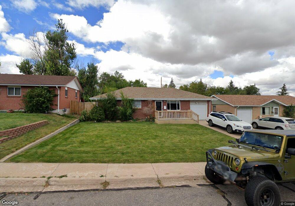
126 Lummis Ct Cheyenne, WY 82007
Estimated Value: $281,000 - $309,795
4
Beds
2
Baths
936
Sq Ft
$320/Sq Ft
Est. Value
About This Home
This home is located at 126 Lummis Ct, Cheyenne, WY 82007 and is currently estimated at $299,699, approximately $320 per square foot. 126 Lummis Ct is a home located in Laramie County with nearby schools including Goins Elementary School, Johnson Junior High School, and South High School.
Ownership History
Date
Name
Owned For
Owner Type
Purchase Details
Closed on
Dec 28, 2010
Sold by
High Plains Enterprises Llc
Bought by
Simpson Laura K
Current Estimated Value
Home Financials for this Owner
Home Financials are based on the most recent Mortgage that was taken out on this home.
Original Mortgage
$138,790
Outstanding Balance
$97,813
Interest Rate
5.5%
Mortgage Type
FHA
Estimated Equity
$201,886
Purchase Details
Closed on
Aug 23, 2010
Sold by
Not Provided
Bought by
High Plains Enterprises Llc
Purchase Details
Closed on
Dec 15, 2009
Sold by
Garcia Adam E and Garcia Rebecca M
Bought by
Lara Construction & Property Consulting
Purchase Details
Closed on
Feb 12, 2001
Sold by
Garcia Adam E and Garcia Rebecca M
Bought by
Garcia Adam E and Garcia Rebecca M
Create a Home Valuation Report for This Property
The Home Valuation Report is an in-depth analysis detailing your home's value as well as a comparison with similar homes in the area
Purchase History
| Date | Buyer | Sale Price | Title Company |
|---|---|---|---|
| Simpson Laura K | -- | None Available | |
| High Plains Enterprises Llc | -- | None Available | |
| Lara Construction & Property Consulting | -- | None Available | |
| Garcia Adam E | -- | Laramie County Abstract & Ti |
Source: Public Records
Mortgage History
| Date | Status | Borrower | Loan Amount |
|---|---|---|---|
| Open | Simpson Laura K | $138,790 |
Source: Public Records
Tax History
| Year | Tax Paid | Tax Assessment Tax Assessment Total Assessment is a certain percentage of the fair market value that is determined by local assessors to be the total taxable value of land and additions on the property. | Land | Improvement |
|---|---|---|---|---|
| 2025 | $1,919 | $22,951 | $2,480 | $20,471 |
| 2024 | $1,919 | $30,143 | $3,306 | $26,837 |
| 2023 | $2,059 | $29,113 | $3,306 | $25,807 |
| 2022 | $1,878 | $26,023 | $3,306 | $22,717 |
| 2021 | $1,600 | $22,121 | $3,306 | $18,815 |
| 2020 | $1,479 | $20,498 | $3,306 | $17,192 |
| 2019 | $1,455 | $20,154 | $3,306 | $16,848 |
| 2018 | $1,230 | $17,202 | $2,482 | $14,720 |
| 2017 | $1,177 | $16,303 | $2,482 | $13,821 |
| 2016 | $1,104 | $15,295 | $2,421 | $12,874 |
| 2015 | $1,153 | $15,966 | $2,421 | $13,545 |
| 2014 | $1,134 | $15,596 | $2,421 | $13,175 |
Source: Public Records
Map
Nearby Homes
- 121 Ahrens Ave
- 1409 W Jefferson Rd
- 216 Cribbon Ave
- 1275 W Jefferson Rd
- 222 Hynds Ave
- 1109 S Arp Ave
- 301 Cribbon Ave
- 1200 W Jefferson Rd
- 302 Abby Rd
- 1717 W Allison Rd
- TBD Wyott Dr
- TBD Snyder Ave
- 1122 W Leisher Rd
- 445 Mccomb Ave
- 221 Desmet Dr
- 508 W 2nd St
- 305 Kay Ave
- 1614 Elsie Jean Trail
- 1533 Elsie Jean Trail
- 1607 Elsie Jean Trail
Your Personal Tour Guide
Ask me questions while you tour the home.