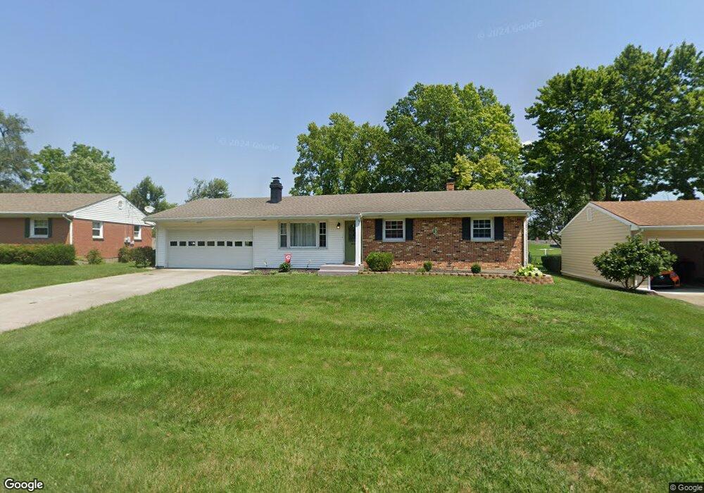
126 Sands Ave Monroe, OH 45050
Estimated Value: $216,000 - $264,000
3
Beds
1
Bath
1,092
Sq Ft
$216/Sq Ft
Est. Value
About This Home
This home is located at 126 Sands Ave, Monroe, OH 45050 and is currently estimated at $235,812, approximately $215 per square foot. 126 Sands Ave is a home located in Butler County with nearby schools including Monroe Primary School, Monroe Elementary School, and Monroe Junior High School.
Ownership History
Date
Name
Owned For
Owner Type
Purchase Details
Closed on
Nov 28, 2022
Sold by
Shaffer Matthew J
Bought by
Shaffer Rental Properties Lc
Current Estimated Value
Purchase Details
Closed on
May 19, 2022
Sold by
Pohlabeln Susan L and Pohlabeln Joseph L
Bought by
Shaffer Matt
Purchase Details
Closed on
Sep 20, 2018
Sold by
Cable Linda
Bought by
Parker Susan and Pohlabeln Susan
Purchase Details
Closed on
Apr 30, 2007
Sold by
Lee Rose Olan and Lee Rose Rosa
Bought by
Cable Linda and Parker Susan
Home Financials for this Owner
Home Financials are based on the most recent Mortgage that was taken out on this home.
Original Mortgage
$115,200
Interest Rate
6.2%
Mortgage Type
Purchase Money Mortgage
Create a Home Valuation Report for This Property
The Home Valuation Report is an in-depth analysis detailing your home's value as well as a comparison with similar homes in the area
Home Values in the Area
Average Home Value in this Area
Purchase History
| Date | Buyer | Sale Price | Title Company |
|---|---|---|---|
| Shaffer Rental Properties Lc | -- | None Listed On Document | |
| Shaffer Matt | $185,000 | Combs Schaefer Ball & Little | |
| Parker Susan | -- | None Available | |
| Cable Linda | $144,000 | Attorney |
Source: Public Records
Mortgage History
| Date | Status | Borrower | Loan Amount |
|---|---|---|---|
| Previous Owner | Cable Linda | $115,200 |
Source: Public Records
Tax History Compared to Growth
Tax History
| Year | Tax Paid | Tax Assessment Tax Assessment Total Assessment is a certain percentage of the fair market value that is determined by local assessors to be the total taxable value of land and additions on the property. | Land | Improvement |
|---|---|---|---|---|
| 2024 | $2,841 | $61,340 | $11,620 | $49,720 |
| 2023 | $2,822 | $59,700 | $11,620 | $48,080 |
| 2022 | $2,386 | $45,700 | $11,620 | $34,080 |
| 2021 | $2,300 | $45,700 | $11,620 | $34,080 |
| 2020 | $2,382 | $45,700 | $11,620 | $34,080 |
| 2019 | $2,084 | $37,080 | $10,570 | $26,510 |
| 2018 | $2,029 | $37,080 | $10,570 | $26,510 |
| 2017 | $2,071 | $37,080 | $10,570 | $26,510 |
| 2016 | $1,933 | $33,170 | $10,570 | $22,600 |
| 2015 | $1,911 | $33,170 | $10,570 | $22,600 |
| 2014 | $1,969 | $33,170 | $10,570 | $22,600 |
| 2013 | $1,969 | $34,450 | $12,340 | $22,110 |
Source: Public Records
Map
Nearby Homes
- 254 Mason Ave
- 225 Mason Ave
- 201 Moder Dr
- 32 W Elm St
- 129 Lewitt Ct
- 857 Hocking Meadow Cir
- 100 N Main St
- 157 Lena Dr
- 416 Heritage Green Dr Unit 2304
- 634 Heritage Green Dr Unit 3305
- 840 Heritage Green Dr Unit 4204
- 929 Heritage Green Dr Unit 9304
- 931 Heritage Green Dr Unit 9204
- 180 Wexford Dr
- 180 Sackett Dr
- 142 Village Ct
- 160 Gorman Ct
- 6935 Gaspar Trail
- CRESTWOOD Plan at Caravel
- KENDALL Plan at Caravel