NOT LISTED FOR SALE

Estimated Value: $233,000 - $389,000

0.51 Acre
$569,735 Price per Acre
22,216 Sq Ft Lot

Last Sold December 21, 2021

Last sale price $186,500

Est. 56% increase in value since last sale

Current estimated payment $1,862/month

388 Days on Market

Highlights

  • Waterfront
  • Partially Wooded Lot
  • Elevated Lot
  • Deep Water Access

About This Lot

As of December 2021

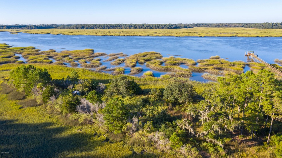
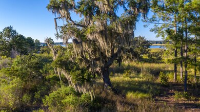
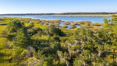
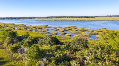
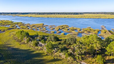
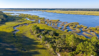
Boaters paradise, over 1/2 acre on the Whale Branch River. This true deep water. Easy access to the Coosaw River, Broad River and Atlantic Ocean. Property located on 2nd lot from the end of Sea Crest lane with panoramic views of the Whale Branch River & marshes as well as Hummock Islands. Neighboring deep water lot at 130 Sea Crest, 0.59 acres also for sale for $195,000.

Last Agent to Sell the Property

Matt Trumps

Tideland Realty Inc License #29302 Listed on: 10/09/2020

Last Buyer's Agent

Scott Bondy

Tideland Realty Inc License #37993

Property Details

Property Type

  • Land

Est. Annual Taxes

  • $3,840

Lot Details

  • 0.51 Acre Lot
  • Elevated Lot
  • Partially Wooded Lot

Additional Features

  • Flood Insurance May Be Required
  • Septic System

Community Details

  • Waterfront
  • Deep Water Access

Listing and Financial Details

  • Assessor Parcel Number R100-013-000-0015-0000

Property Details

Property Type

Land

Est. Annual Taxes

$3,840

Lot Details

0

Listing Details

  • Directions: Hwy 21 past MCAS, R at Stuarts Point Road, Left at end of paved road, L at Sea Crest Lane, 2nd lot from the end.
  • Prop. Type: Land
  • Property Sub-Type: Resident S/D Lot
  • Lot Size Acres: 0.51
  • Ownership: Yes
  • MLS Status: Closed
  • Keywords Waterfront: Deep Water (Three Ft Min)
  • Keywords Dock: Possible 150 Ft +
  • General Property Description Bank Owned: No
  • General Property Description Short Sale: No
  • General Property Description Dock Permits in Hand: No
  • Community Waterfront Community2: Yes
  • General Property Description:Lot Dimensions: Plat In Documents
  • Utilities Available Septic: Yes
  • Flood Insurance Required2: Yes
  • Topography HighDry: Yes
  • Topography Partially Wooded: Yes
  • Utilities Available Public Water2: Yes
  • Lot Location Deep Water: Yes
  • Special Features: None
  • Property Sub Type: LotsLands

Exterior Features

  • Waterfront Features: Deep Water (Three Ft Min)
  • Waterfront: Yes

Utilities

  • Utilities: Septic
  • Water Source: Public

Lot Info

  • Zoning: Residential
  • Lot Dimensions: Plat In Documents
  • Lot Size Sq Ft: 22216.0
  • ResoLotSizeUnits: Acres
  • Parcel Number: R100-013-000-0015-0000
  • ResoLotSizeUnits: Acres

Ownership History

Date Name Owned For Owner Type

Purchase Details

Listed on
Oct 9, 2020
Closed on
Dec 21, 2021
Sold by
Jordan Robert J and Murray Cad E
Bought by
Graham Charles M and Graham Donna Gail
Seller's Agent
Matt Trumps
Tideland Realty Inc
Buyer's Agent
Scott Bondy
Tideland Realty Inc
List Price
$2,190,000
Sold Price
$186,500
Premium/Discount to List
-$2,003,500
-91.48%
Total Days on Market
388
Current Estimated Value
$290,565

Home Financials for this Owner

Home Financials are based on the most recent Mortgage that was taken out on this home.
Estimated Appreciation
$104,065
Avg. Annual Appreciation
13.71%
Original Mortgage
$158,525
Outstanding Balance
$128,600
Interest Rate
2.27%
Mortgage Type
Purchase Money Mortgage
Estimated Equity
$163,023

Purchase Details

Closed on
Jul 15, 2005
Sold by
Evely W W
Bought by
Jordan Robert J and Murray Carl E

Home Financials for this Owner

Home Financials are based on the most recent Mortgage that was taken out on this home.
Original Mortgage
$156,000
Interest Rate
5.48%
Mortgage Type
Purchase Money Mortgage
Source: Public Records

Range of Values:

Collateral Analytics

Collateral Analytics Collateral Analytics AVMs (Automated Valuation Model) employ a number of statistical approaches combined with neighborhood-specific comparable selection guarantees the most up-to-date and precise valuations.

Not Available

Collateral Analytics does not have data for the current month. Please view the chart for historical values.

ICE

ICE Mortgage Technology ICE Mortgage Technology’s AVM (Automated Valuation Model) is a state-of-the-art online residential property valuation tool that provides a quick and accurate estimate of the value of almost any home in the U.S.

Not Available

ICE Mortgage Technology does not have data for the current month. Please view the chart for historical values.

First American

First American First American Data & Analytics’ next-generation AVM combines unrivaled data assets with a blended ensemble of valuation models to produce highly accurate, reliable valuations you can trust.

Not Available

First American does not have data for the current month. Please view the chart for historical values.

Quantarium

Quantarium Quantarium’s valuation service, repeatedly proven the industry’s most accurate and comprehensive, is supercharged with a self-learning and auto-tuning AI engine that continually becomes smarter and more accurate as it processes daily inputs from the industry’s leading RE data lake.

Not Available

Quantarium does not have data for the current month. Please view the chart for historical values.

Average Value
Not Available
List Price
Sold Price
Create a Home Valuation Report for This Property
The Home Valuation Report is an in-depth analysis detailing your home's value as well as a comparison with similar homes in the area

Home Values in the Area

Source: Public Records

Average Home Value in this Area


Source: Public Records

Purchase History

Date Buyer Sale Price Title Company
Graham Charles M $186,500 None Available
Jordan Robert J $180,000 --
Source: Public Records

Mortgage History

Date Status Borrower Loan Amount
Open Graham Charles M $158,525
Previous Owner Jordan Robert J $156,000
Source: Public Records

Property History

Date Event Price Change Sq Ft Price
12/21/2021 12/21/21 Sold $186,500 -91.5% --
11/01/2021 11/01/21 Pending -- -- --
10/09/2020 10/09/20 For Sale $2,190,000 -- --
Source: Lowcountry Regional MLS

Tax History Compared to Growth

Source: Public Records

Tax History

Year Tax Paid Tax Assessment Tax Assessment Total Assessment is a certain percentage of the fair market value that is determined by local assessors to be the total taxable value of land and additions on the property. Land Improvement
2024 $3,840 $12,870 $0 $0
2023 $3,840 $12,870 $0 $0
2022 $3,435 $11,190 $0 $0
2021 $2,751 $9,130 $0 $0
2020 $2,676 $9,130 $0 $0
2019 $2,644 $9,130 $0 $0
2018 $2,515 $9,130 $0 $0
2017 $2,232 $7,940 $0 $0
2016 $2,183 $7,940 $0 $0
2014 $1,567 $7,940 $0 $0
Source: Public Records

Agents Affiliated with this Home

  • Section Image
  • Section Image
See All Agents

Map

Source: Lowcountry Regional MLS

MLS Number: 168383

Lowcountry Regional MLS

APN: R100-013-000-0015-0000