Estimated Value: $89,000 - $174,000
3
Beds
1
Bath
1,424
Sq Ft
$83/Sq Ft
Est. Value
About This Home
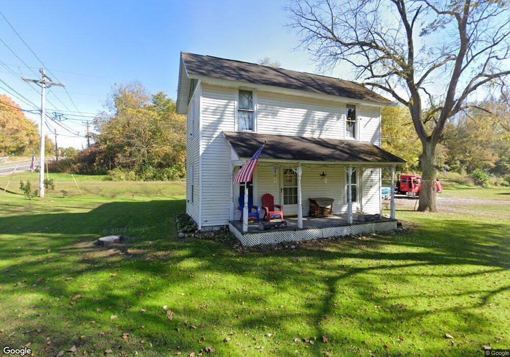
This home is located at 1260 S Fork Rd, Heath, OH 43056 and is currently estimated at $117,552, approximately $82 per square foot. 1260 S Fork Rd is a home located in Licking County with nearby schools including Jackson Intermediate School, Lakewood Middle School, and Lakewood High School.
Ownership History
Date
Name
Owned For
Owner Type
Purchase Details
Closed on
Nov 18, 2025
Sold by
Ewing Marilyn S
Bought by
1260Sfroad Llc
Current Estimated Value
Purchase Details
Closed on
Feb 28, 2019
Sold by
Ewing Marilyn S
Bought by
Strickland Jeff
Home Financials for this Owner
Home Financials are based on the most recent Mortgage that was taken out on this home.
Original Mortgage
$75,000
Interest Rate
5.05%
Mortgage Type
Land Contract Argmt. Of Sale
Create a Home Valuation Report for This Property
The Home Valuation Report is an in-depth analysis detailing your home's value as well as a comparison with similar homes in the area
Purchase History
| Date | Buyer | Sale Price | Title Company |
|---|---|---|---|
| 1260Sfroad Llc | $90,000 | None Listed On Document | |
| Strickland Jeff | $90,000 | None Available |
Source: Public Records
Mortgage History
| Date | Status | Borrower | Loan Amount |
|---|---|---|---|
| Previous Owner | Strickland Jeff | $75,000 |
Source: Public Records
Tax History
| Year | Tax Paid | Tax Assessment Tax Assessment Total Assessment is a certain percentage of the fair market value that is determined by local assessors to be the total taxable value of land and additions on the property. | Land | Improvement |
|---|---|---|---|---|
| 2024 | $2,085 | $47,500 | $16,070 | $31,430 |
| 2023 | $3,728 | $47,500 | $16,070 | $31,430 |
| 2022 | $1,830 | $33,050 | $12,570 | $20,480 |
| 2021 | $1,868 | $33,050 | $12,570 | $20,480 |
| 2020 | $1,880 | $33,050 | $12,570 | $20,480 |
| 2019 | $1,552 | $27,720 | $11,970 | $15,750 |
| 2018 | $1,754 | $0 | $0 | $0 |
| 2017 | $2,287 | $0 | $0 | $0 |
| 2016 | $223 | $0 | $0 | $0 |
| 2015 | $377 | $0 | $0 | $0 |
| 2014 | $520 | $0 | $0 | $0 |
| 2013 | $529 | $0 | $0 | $0 |
Source: Public Records
Map
Nearby Homes
- 307 Nicholas Dr Unit 46
- 92 Jonathan Dr
- 1285 Bluejack Ln
- 105 Clark Ave
- 164 Licking View Dr
- 381 Laurel Oaks Ln
- 944 Fieldson Dr
- 399 Laurel Oaks Ln Unit Lot 131
- 403 Laurel Oaks Ln Unit Lot 132
- 1265 Green Valley Dr
- 1094 Aldine Dr
- 602 Deanna Stroll Rd
- 625 Fulla Ln SE
- 780 Fieldson Dr
- 233 Wildwood Ct Unit 233C
- 645 Kensington Dr Unit 645
- 101 Fieldpoint Rd
- 18 Swainford Dr
- 231 Fieldpoint Rd
- 616 Huron Dr
- 152 Irving Wick Dr E Unit 13
- 152 Irving Wick Dr E Unit 91
- 152 Irving Wick Dr E Unit L81
- 152 Irving Wick Dr E Unit 111
- 152 Irving Wick Dr E Unit 68
- 152 Irving Wick Dr E Unit 42
- 152 Irving Wick Dr E Unit Lot 47
- 152 Irving Wick Dr E Unit Lot 81
- 152 Irving Wick Dr E Unit Lot 15
- 152 Irving Wick Dr E Unit Lot 60
- 152 Irving Wick Dr E Unit LOT 96
- 152 Irving Wick Dr E Unit Lot 72
- 150 Irving Wick Dr E
- 401 Dawn Ln
- 302 Nicholas Dr
- 1325 Sequoia Ln
- 1305 Sequoia Ln
- 99 Dorsey Mill Rd E
- 301 Nicholas Dr Unit 26
- 306 Nicholas Dr
Your Personal Tour Guide
Ask me questions while you tour the home.