
Seller's Agent in 2025
Rodney Hamrick
World Impact Real Estate
(251) 366-5464
1 in this area
23 Total Sales
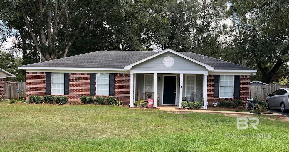


Looking for a reasonably priced home in popular west Mobile? This is it!! Located just west of Baker High School, this property is in a prime location with quick access to the Airport and roads leading to I-10. I-10 west directs you to Biloxi and New Orleans. I-10 east directs you to the beautiful white sandy beaches of Alabama and Pensacola. It's also convenient to shopping galore, and restaurants, yet it's nestled back in a subdivision on a cul-de-sac road. This home has a well manicured back yard with privacy fence, plus an oversized concrete patio for those evenings spent outside. There are lights and even a playhouse, plus a burn barrel. The house itself has been updated (roof, hot water heater, counter tops, paint, etc..) within the last few years and looks barely lived in. Enjoy the wood burning fireplace on those chilly winter nights under a vaulted ceiling in the Great Room. The Primary bathroom is located directly off of the bedroom with a huge mirror and double vanity. You will want to call this your home. Buyer to verify all information during due diligence.
| Date | Type | Sale Price | Title Company |
|---|---|---|---|
| Warranty Deed | $207,500 | Delta South Title Inc | |
| Warranty Deed | -- | None Available | |
| Warranty Deed | -- | -- |
| Date | Status | Loan Amount | Loan Type |
|---|---|---|---|
| Open | $207,500 | Balloon | |
| Previous Owner | $80,191 | No Value Available |
| Date | Event | Price | List to Sale | Price per Sq Ft |
|---|---|---|---|---|
| 10/27/2025 10/27/25 | Sold | $207,500 | +3.8% | $152 / Sq Ft |
| 09/26/2025 09/26/25 | Pending | -- | -- | -- |
| 09/23/2025 09/23/25 | For Sale | $199,900 | -- | $147 / Sq Ft |
| Year | Tax Paid | Tax Assessment Tax Assessment Total Assessment is a certain percentage of the fair market value that is determined by local assessors to be the total taxable value of land and additions on the property. | Land | Improvement |
|---|---|---|---|---|
| 2025 | -- | $29,500 | $6,000 | $23,500 |
| 2024 | $0 | $13,700 | $3,000 | $10,700 |
| 2023 | $525 | $11,930 | $3,300 | $8,630 |
| 2022 | $455 | $10,760 | $3,000 | $7,760 |
| 2021 | $463 | $10,920 | $2,400 | $8,520 |
| 2020 | $463 | $10,920 | $2,400 | $8,520 |
| 2019 | $461 | $10,880 | $0 | $0 |
| 2018 | $429 | $10,220 | $0 | $0 |
| 2017 | $505 | $10,360 | $0 | $0 |
| 2016 | $461 | $10,880 | $0 | $0 |
| 2013 | $505 | $10,240 | $0 | $0 |
Seller's Agent in 2025
Rodney Hamrick
World Impact Real Estate
(251) 366-5464
1 in this area
23 Total Sales
Buyer's Agent in 2025
Sam Calderone
RE/MAX
(251) 680-6635
1 in this area
277 Total Sales
Source: Baldwin REALTORS®
MLS Number: 385648
APN: 27-08-27-0-000-004.443
Disclaimer: Certain information contained herein is derived from information provided by parties other than Homes.com. All information provided is deemed reliable, but is not guaranteed to be accurate and should be independently verified.
![]() IDX information is provided exclusively for personal, non-commercial use, and may not be used for any purpose other than to identify prospective properties consumers may be interested in purchasing. Information is deemed reliable but not guaranteed.
IDX information is provided exclusively for personal, non-commercial use, and may not be used for any purpose other than to identify prospective properties consumers may be interested in purchasing. Information is deemed reliable but not guaranteed.
Ask me questions while you tour the home.