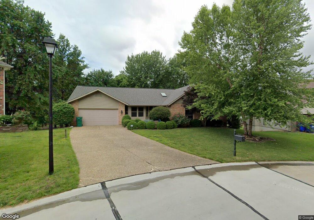
1261 Stephenridge Dr Saint Charles, MO 63304
Estimated Value: $368,000 - $411,000
3
Beds
2
Baths
1,785
Sq Ft
$215/Sq Ft
Est. Value
About This Home
This home is located at 1261 Stephenridge Dr, Saint Charles, MO 63304 and is currently estimated at $384,301, approximately $215 per square foot. 1261 Stephenridge Dr is a home located in St. Charles County with nearby schools including Central Elementary School, Bryan Middle School, and Francis Howell Union High School.
Ownership History
Date
Name
Owned For
Owner Type
Purchase Details
Closed on
Oct 13, 2016
Sold by
Mudd Robert S and Mudd Jennifer
Bought by
Mudd Robert S and Mudd Jennifer
Current Estimated Value
Home Financials for this Owner
Home Financials are based on the most recent Mortgage that was taken out on this home.
Original Mortgage
$195,000
Outstanding Balance
$156,230
Interest Rate
3.44%
Mortgage Type
New Conventional
Estimated Equity
$228,071
Purchase Details
Closed on
Oct 28, 2015
Sold by
Murphy Jeffrey R and Murphy Cheryl A
Bought by
Mudd Robert S
Create a Home Valuation Report for This Property
The Home Valuation Report is an in-depth analysis detailing your home's value as well as a comparison with similar homes in the area
Home Values in the Area
Average Home Value in this Area
Purchase History
| Date | Buyer | Sale Price | Title Company |
|---|---|---|---|
| Mudd Robert S | -- | Title Partners Agency Llc | |
| Mudd Robert S | -- | None Available |
Source: Public Records
Mortgage History
| Date | Status | Borrower | Loan Amount |
|---|---|---|---|
| Open | Mudd Robert S | $195,000 |
Source: Public Records
Tax History Compared to Growth
Tax History
| Year | Tax Paid | Tax Assessment Tax Assessment Total Assessment is a certain percentage of the fair market value that is determined by local assessors to be the total taxable value of land and additions on the property. | Land | Improvement |
|---|---|---|---|---|
| 2025 | $3,667 | $67,817 | -- | -- |
| 2023 | $3,665 | $61,378 | $0 | $0 |
| 2022 | $3,074 | $47,766 | $0 | $0 |
| 2021 | $3,077 | $47,766 | $0 | $0 |
| 2020 | $2,852 | $42,824 | $0 | $0 |
| 2019 | $2,839 | $42,824 | $0 | $0 |
| 2018 | $2,714 | $39,126 | $0 | $0 |
| 2017 | $2,692 | $39,126 | $0 | $0 |
| 2016 | $2,576 | $36,053 | $0 | $0 |
| 2015 | $2,543 | $36,053 | $0 | $0 |
| 2014 | $2,444 | $33,620 | $0 | $0 |
Source: Public Records
Map
Nearby Homes
- 136 Shirley Ridge Dr Unit 136C
- 4691 Kellykris Dr
- 4677 Onondaga Trail
- 1231 Piedmont Cir
- 36 Cloverdale Dr
- 3624 Capri Way
- 142 Newgrange Pass
- 191 Muirfield Forest Ct
- 207 Kreder Ln
- 950 Haversham Dr
- Westbrook Plan at Kreder Farms
- Savannah Plan at Kreder Farms
- Rockport Plan at Kreder Farms
- Monaco Plan at Kreder Farms
- Canterbury Plan at Kreder Farms
- Princeton Plan at Kreder Farms
- Sydney Plan at Kreder Farms
- Bradford Plan at Kreder Farms
- Bridgeport Plan at Kreder Farms
- Rochester Plan at Kreder Farms
- 1259 Stephenridge Dr
- 1263 Stephenridge Dr
- 1288 Robertridge Dr
- 1284 Robertridge Dr
- 1290 Robertridge Dr
- 1265 Stephenridge Dr
- 1257 Stephenridge Dr
- 1258 Stephenridge Dr
- 1282 Robertridge Dr
- 1292 Robertridge Dr
- 1264 Stephenridge Dr
- 1280 Robertridge Dr
- 1267 Stephenridge Dr
- 1294 Robertridge Dr
- 1289 Robertridge Dr
- 1287 Robertridge Dr
- 1291 Robertridge Dr
- 1254 Stephenridge Dr
- 1266 Stephenridge Dr
- 1285 Robertridge Dr