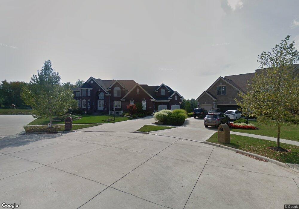
12611 Calumet Cir Strongsville, OH 44149
Estimated Value: $921,746 - $1,199,000
4
Beds
5
Baths
6,110
Sq Ft
$176/Sq Ft
Est. Value
About This Home
This home is located at 12611 Calumet Cir, Strongsville, OH 44149 and is currently estimated at $1,074,187, approximately $175 per square foot. 12611 Calumet Cir is a home located in Cuyahoga County with nearby schools including Strongsville High School, Strongsville Academy, and Sts Joseph & John Interparochial School.
Ownership History
Date
Name
Owned For
Owner Type
Purchase Details
Closed on
Sep 27, 2007
Sold by
Waterford Crossing Sales Llc
Bought by
Martin Daniel R and Martin Kelly M
Current Estimated Value
Home Financials for this Owner
Home Financials are based on the most recent Mortgage that was taken out on this home.
Original Mortgage
$417,000
Outstanding Balance
$266,432
Interest Rate
6.66%
Mortgage Type
Purchase Money Mortgage
Estimated Equity
$807,755
Create a Home Valuation Report for This Property
The Home Valuation Report is an in-depth analysis detailing your home's value as well as a comparison with similar homes in the area
Home Values in the Area
Average Home Value in this Area
Purchase History
| Date | Buyer | Sale Price | Title Company |
|---|---|---|---|
| Martin Daniel R | $685,524 | Chicago Title Insurance Co |
Source: Public Records
Mortgage History
| Date | Status | Borrower | Loan Amount |
|---|---|---|---|
| Open | Martin Daniel R | $417,000 |
Source: Public Records
Tax History Compared to Growth
Tax History
| Year | Tax Paid | Tax Assessment Tax Assessment Total Assessment is a certain percentage of the fair market value that is determined by local assessors to be the total taxable value of land and additions on the property. | Land | Improvement |
|---|---|---|---|---|
| 2024 | $14,160 | $301,595 | $36,855 | $264,740 |
| 2023 | $15,321 | $244,690 | $31,360 | $213,330 |
| 2022 | $15,210 | $244,690 | $31,360 | $213,330 |
| 2021 | $15,090 | $244,690 | $31,360 | $213,330 |
| 2020 | $15,940 | $228,660 | $29,300 | $199,360 |
| 2019 | $15,472 | $653,300 | $83,700 | $569,600 |
| 2018 | $14,042 | $228,660 | $29,300 | $199,360 |
| 2017 | $14,663 | $221,030 | $27,340 | $193,690 |
| 2016 | $14,544 | $221,030 | $27,340 | $193,690 |
| 2015 | $20,827 | $221,030 | $27,340 | $193,690 |
| 2014 | $20,827 | $206,570 | $25,550 | $181,020 |
Source: Public Records
Map
Nearby Homes
- 12515 Countryside Dr
- 11405 Reserve Way
- 12579 Woodberry Ln
- 23669 Wally's Way
- 12366 Coopers Run
- 10842 Fence Row Dr
- 22235 North Trail
- 12490 Challenge Way
- 10800 Meadow Trail
- 10794 Waterfall Rd
- 22283 South Trail
- 21469 Woodview Cir
- 22125 Olde Creek Trail
- 23540 Celestine Way
- 23769 Wally's Way
- 0 Priem Rd
- 23761 St Andrews Dr
- 22300 Rock Creek Cir
- 10353 Oak Branch Trail
- 10008 Plum Brook Ln
- 12617 Calumet Cir
- 12623 Calument Cir
- 12606 Calumet Cir
- 12507 Saddlebrook Ln
- 12600 Calumet Cir
- 12501 Saddlebrook Ln
- 12519 Saddlebrook Ln
- 12620 S Churchill Way
- 12594 Calumet Cir
- 12495 Saddlebrook Ln
- 12525 Saddlebrook Ln
- 12503 Countryside Dr
- 12588 S Churchill Way
- 12509 Countryside Dr
- 12652 S Churchill Way
- 12623 S Churchill Way
- 12521 Countryside Dr
- 12489 Saddlebrook Ln
- 12633 S Churchill Way
- 12510 Saddlebrook Ln