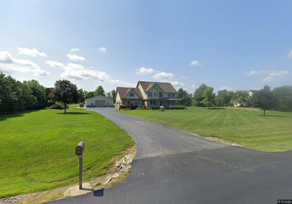
12617 W Baker Rd Manhattan, IL 60442
Estimated Value: $627,000 - $650,711
3
Beds
3
Baths
2,790
Sq Ft
$229/Sq Ft
Est. Value
About This Home
This home is located at 12617 W Baker Rd, Manhattan, IL 60442 and is currently estimated at $637,678, approximately $228 per square foot. 12617 W Baker Rd is a home located in Will County with nearby schools including Wilson Creek Elementary School, Anna McDonald Elementary School, and Manhattan Junior High School.
Ownership History
Date
Name
Owned For
Owner Type
Purchase Details
Closed on
Mar 15, 2014
Sold by
Hotwagner Edward and Hotwagner Edward M
Bought by
Hotwagner Family Declaration Of Trust
Current Estimated Value
Purchase Details
Closed on
Sep 23, 1999
Sold by
Jordan Conrad R and Jordan Alyce M
Bought by
Hotwagner Edward and Hotwagner Gina
Purchase Details
Closed on
May 17, 1994
Sold by
Bruinius Charles and Bruinius Rosina
Bought by
Jordan Conrad R and Jordan Alyce M
Create a Home Valuation Report for This Property
The Home Valuation Report is an in-depth analysis detailing your home's value as well as a comparison with similar homes in the area
Home Values in the Area
Average Home Value in this Area
Purchase History
| Date | Buyer | Sale Price | Title Company |
|---|---|---|---|
| Hotwagner Family Declaration Of Trust | -- | None Available | |
| Hotwagner Edward | $74,500 | -- | |
| Jordan Conrad R | $52,500 | -- |
Source: Public Records
Tax History Compared to Growth
Tax History
| Year | Tax Paid | Tax Assessment Tax Assessment Total Assessment is a certain percentage of the fair market value that is determined by local assessors to be the total taxable value of land and additions on the property. | Land | Improvement |
|---|---|---|---|---|
| 2024 | $15,044 | $175,000 | $40,500 | $134,500 |
| 2023 | $15,044 | $168,300 | $37,500 | $130,800 |
| 2022 | $14,052 | $157,300 | $30,150 | $127,150 |
| 2021 | $14,079 | $157,300 | $30,150 | $127,150 |
| 2020 | $13,622 | $152,050 | $30,150 | $121,900 |
| 2019 | $13,444 | $150,650 | $28,750 | $121,900 |
| 2018 | $12,945 | $144,400 | $28,750 | $115,650 |
| 2017 | $12,601 | $139,950 | $28,750 | $111,200 |
| 2016 | $12,055 | $133,450 | $28,750 | $104,700 |
| 2015 | $11,466 | $127,850 | $27,650 | $100,200 |
| 2014 | $11,466 | $125,650 | $27,650 | $98,000 |
| 2013 | $11,466 | $133,750 | $27,650 | $106,100 |
Source: Public Records
Map
Nearby Homes
- Lot 1 Baker Rd
- 2980 Oak Rail Dr
- 1401 Ottawa Dr
- 13620 W Carriage Ln
- 24001 S Sunset Lakes Dr
- 13813 Mckenna Ct
- 13754 W Memorial Dr
- 13745 W Memorial Dr
- 13828 W Crescenzo Dr
- 22957 Devonshire Ln
- 24241 S Sunset Lakes Dr
- 24232 S Bay to Bay Ct
- 2165 High View Rd
- 11392 Mckenna Dr
- 22559 S Country Ln
- 2124 Sky Harbor Dr
- 23933 S Roberts St
- 2164 Sky Harbor Dr
- 23952 Roberts St
- 2125 Sky Harbor Dr
- 12637 W Baker Rd
- 12559 W Baker Rd
- 12608 W Baker Rd
- 12636 W Baker Rd
- 12539 W Baker Rd
- 12656 W Baker Rd
- 12550 W Baker Rd
- 12642 Arberry Ct
- 24028 S Indian Trail
- 12717 W Baker Rd
- 12630 Arberry Ct
- 24014 S Indian Trail
- 12517 W Baker Rd
- 12520 W Baker Rd
- 12654 Arberry Ct
- 24000 S Indian Trail
- 23811 S Bridle Path Dr
- 12641 Arberry Ct
- 23764 S Bridle Path Dr
- 24027 S Indian Trail