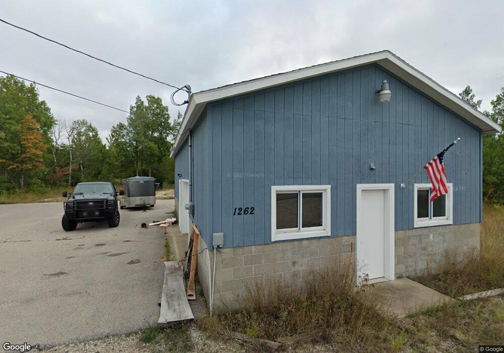
1262 U S 31 Pellston, MI 49769
Estimated Value: $82,292
Studio
--
Bath
960
Sq Ft
$86/Sq Ft
Est. Value
About This Home
This home is located at 1262 U S 31, Pellston, MI 49769 and is currently estimated at $82,292, approximately $85 per square foot. 1262 U S 31 is a home located in Emmet County with nearby schools including Pellston Elementary School and Pellston Middle/High School.
Ownership History
Date
Name
Owned For
Owner Type
Purchase Details
Closed on
Oct 25, 2021
Sold by
Hacker Neil
Bought by
Pell Prop Llc
Current Estimated Value
Purchase Details
Closed on
Aug 17, 2021
Sold by
Hacker Neil
Bought by
Hacker Neil and Hacker James Neil
Home Financials for this Owner
Home Financials are based on the most recent Mortgage that was taken out on this home.
Original Mortgage
$1
Interest Rate
2.7%
Mortgage Type
New Conventional
Purchase Details
Closed on
Jan 4, 2008
Sold by
North Country Renting And Leasing Inc
Bought by
Conrad Richard and Richard Conrad Trust Dated February 13,
Create a Home Valuation Report for This Property
The Home Valuation Report is an in-depth analysis detailing your home's value as well as a comparison with similar homes in the area
Purchase History
| Date | Buyer | Sale Price | Title Company |
|---|---|---|---|
| Pell Prop Llc | -- | -- | |
| Hacker Neil | -- | -- | |
| Hacker Neil | $65,000 | -- | |
| Conrad Richard | -- | -- |
Source: Public Records
Mortgage History
| Date | Status | Borrower | Loan Amount |
|---|---|---|---|
| Previous Owner | Hacker Neil | $1 |
Source: Public Records
Tax History
| Year | Tax Paid | Tax Assessment Tax Assessment Total Assessment is a certain percentage of the fair market value that is determined by local assessors to be the total taxable value of land and additions on the property. | Land | Improvement |
|---|---|---|---|---|
| 2025 | $1,339 | $38,800 | $13,800 | $25,000 |
| 2024 | $10 | $34,900 | $13,800 | $21,100 |
| 2023 | $1,239 | $32,500 | $12,500 | $20,000 |
| 2022 | $1,239 | $30,100 | $10,000 | $20,100 |
| 2021 | $994 | $30,100 | $18,800 | $11,300 |
| 2020 | $992 | $30,100 | $18,800 | $11,300 |
| 2019 | -- | $29,900 | $18,800 | $11,100 |
| 2018 | -- | $29,500 | $18,800 | $10,700 |
| 2017 | -- | $29,500 | $18,800 | $10,700 |
| 2016 | -- | $29,500 | $18,800 | $10,700 |
| 2015 | -- | $29,000 | $0 | $0 |
| 2014 | -- | $29,500 | $0 | $0 |
Source: Public Records
Map
Nearby Homes
- 6421 Airport Crossing Rd Unit 1
- 6457 State St
- TBD Teal Rd
- 8959 Robinson Rd
- 8016 Silver Strand Rd
- 11115 Douglas Lake Rd
- 6105 U S 31
- 10999 Koepke Rd
- 10222 W Munro Lake Dr
- 4333 U S 31
- 5100 N Bay Way
- 8586 N Us 31
- 1830 Indian Point Rd
- 1975 &1995 Club House Dr
- 1975 + 1995 Club House Dr
- 6167 Lambert Dr
- 1442 Indian Point Rd
- 3955 S Pleasantview Rd Unit 6
- 1253 Walkabout Ln
- 5441 Valley Rd
- 1268 U S 31
- 1290 N Us-31
- 1290 U S 31
- 1208 N Us 31 Hwy
- 1208 U S 31 Unit 4.5 acres
- 1208 U S 31
- 1208 N Us Highway 31
- 1302 N Us Highway 31
- 1302 N Us Highway 31
- 1302 U S 31
- 1204 N Us 31 Hwy
- 1200 N Us Highway 31
- 1120 N Us Highway 31
- 1120 U S 31
- 1120 N Us-31
- 1388 U S 31 Unit 2.6 ACRES
- 1388 U S 31
- 1388 N Us Highway 31
- 1388 N Us Highway 31
- 1410 U S 31
Your Personal Tour Guide
Ask me questions while you tour the home.