
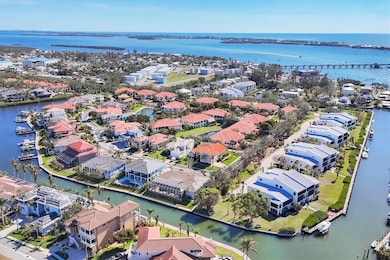


12622 Safe Harbour Dr Cortez, FL 34215
Estimated payment $7,399/month
Highlights
- Fitness Center
- Screened Pool
- View of Trees or Woods
- Property is near a marina
- Gated Community
- Clubhouse
About This Home
Looking for a private, gated, low-maintenance community near the beaches of Anna Maria Island and the Cortez Village marinas, only seven miles from IMG Sports Academy and convenient to Sarasota and Tampa airports? Harbour Landings is an exclusive private, gated community on the Intracoastal Waterway offering you this spacious sunny home with plenty of room for guests with a split floorplan and the privacy of your pool patio with a nice hot spa. Safe Harbour earned its name with the home elevation of 12 feet, 2 inches. Inside the sunny open spaces and 10-foot ceilings, the sun pours through the arched windows to the family room and kitchen. Sliders open up to the screened pool patio, it’s that Florida lifestyle. With a split floor plan on the first floor, the primary suite has complete privacy and two walk-in closets. The bath enjoys dual sinks, separate tub and shower. The guest wing offers one en-suite bedroom and one with a full hallway bath convenient to the family room. The surprise bonus is the oversized room (25 by 25 feet) on the second floor with a half bath with room to expand it to a full. What do you think about office, fourth bedroom or game room? The main level has been refreshed with new paint throughout and luxury vinyl flooring in the living dining area and home office. The Kitchen has been refreshed with new granite countertops and tile backsplash. Harbour Landing and Cortez are all about lifestyle with beaches and boats nearby. Add to that really fresh fish at all the local fun restaurants and dreamy, picturesque sunsets on the white sandy beaches of Anna Maria and Longboat Key. Need a night on the town? Enjoy the Cultural Coast of downtown Sarasota with its ballet, opera, art museums and live theatre. If travel is in your portfolio, you have the option of two international airports, Sarasota and Tampa. What are you waiting for?
Listing Agent
PREMIER SOTHEBY'S INTERNATIONAL REALTY Brokerage Phone: 941-364-4000 License #0663919 Listed on: 10/20/2025

Co-Listing Agent
PREMIER SOTHEBY'S INTERNATIONAL REALTY Brokerage Phone: 941-364-4000 License #3153404
Home Details
Home Type
- Single Family
Est. Annual Taxes
- $8,815
Year Built
- Built in 2008
Lot Details
- 0.27 Acre Lot
- Northeast Facing Home
- Corner Lot
- Landscaped with Trees
- Property is zoned PDR/CH
HOA Fees
- $429 Monthly HOA Fees
Parking
- 2 Car Attached Garage
- Side Facing Garage
- Garage Door Opener
- Driveway
Home Design
- Coastal Architecture
- Bi-Level Home
- Slab Foundation
- Tile Roof
- Block Exterior
- Stucco
Interior Spaces
- 3,742 Sq Ft Home
- Shelving
- Crown Molding
- Tray Ceiling
- High Ceiling
- Ceiling Fan
- Shutters
- Sliding Doors
- Family Room
- Separate Formal Living Room
- Formal Dining Room
- Den
- Inside Utility
- Utility Room
- Views of Woods
Kitchen
- Eat-In Kitchen
- Range
- Microwave
- Ice Maker
- Dishwasher
- Stone Countertops
- Solid Wood Cabinet
- Disposal
Flooring
- Engineered Wood
- Carpet
- Laminate
- Ceramic Tile
- Luxury Vinyl Tile
Bedrooms and Bathrooms
- 4 Bedrooms
- Primary Bedroom on Main
- Split Bedroom Floorplan
- En-Suite Bathroom
- Walk-In Closet
- Private Water Closet
- Bathtub With Separate Shower Stall
Laundry
- Laundry Room
- Washer and Electric Dryer Hookup
Eco-Friendly Details
- Reclaimed Water Irrigation System
Pool
- Screened Pool
- Heated In Ground Pool
- Heated Spa
- In Ground Spa
- Gunite Pool
- Saltwater Pool
- Fence Around Pool
- Pool Deck
- Auto Pool Cleaner
- Pool Lighting
Outdoor Features
- Property is near a marina
- Covered Patio or Porch
- Exterior Lighting
- Rain Gutters
Location
- Flood Zone Lot
- Flood Insurance May Be Required
Schools
- Sea Breeze Elementary School
- W.D. Sugg Middle School
- Bayshore High School
Utilities
- Central Air
- Heat Pump System
- Underground Utilities
- High Speed Internet
Listing and Financial Details
- Visit Down Payment Resource Website
- Tax Lot 13
- Assessor Parcel Number 75994-0865-9
Community Details
Overview
- Association fees include escrow reserves fund, ground maintenance, management, recreational facilities
- Dylan Clements Association, Phone Number (941) 554-8838
- Harbour Landing Community
- Harbour Landings Subdivision
- Leased Association Recreation
- The community has rules related to deed restrictions, vehicle restrictions
Recreation
- Tennis Courts
- Recreation Facilities
- Fitness Center
- Community Pool
Additional Features
- Clubhouse
- Gated Community
Map
Home Values in the Area
Average Home Value in this Area
Tax History
| Year | Tax Paid | Tax Assessment Tax Assessment Total Assessment is a certain percentage of the fair market value that is determined by local assessors to be the total taxable value of land and additions on the property. | Land | Improvement |
|---|---|---|---|---|
| 2025 | $8,922 | $667,244 | -- | -- |
| 2023 | $8,815 | $629,552 | $0 | $0 |
| 2022 | $8,608 | $611,216 | $0 | $0 |
| 2021 | $8,288 | $593,414 | $0 | $0 |
| 2020 | $8,557 | $585,221 | $0 | $0 |
| 2019 | $8,446 | $572,064 | $0 | $0 |
| 2018 | $8,393 | $561,397 | $0 | $0 |
| 2017 | $7,822 | $549,850 | $0 | $0 |
| 2016 | $7,824 | $538,541 | $0 | $0 |
Property History
| Date | Event | Price | List to Sale | Price per Sq Ft |
|---|---|---|---|---|
| 02/16/2026 02/16/26 | Price Changed | $1,295,000 | -7.2% | $346 / Sq Ft |
| 01/09/2026 01/09/26 | Price Changed | $1,395,000 | -6.7% | $373 / Sq Ft |
| 10/20/2025 10/20/25 | For Sale | $1,495,000 | -- | $400 / Sq Ft |
Purchase History
| Date | Type | Sale Price | Title Company |
|---|---|---|---|
| Corporate Deed | $510,000 | Msc Title Inc |
Mortgage History
| Date | Status | Loan Amount | Loan Type |
|---|---|---|---|
| Open | $408,000 | New Conventional |
Source: Stellar MLS
MLS Number: A4669122
APN: 75994-0865-9
Disclaimer: Certain information contained herein is derived from information provided by parties other than Homes.com. All information provided is deemed reliable, but is not guaranteed to be accurate and should be independently verified.
![]() Based on information submitted to the MLS GRID. All data is obtained from various sources and may not have been verified by broker or MLS GRID. Supplied Open House Information is subject to change without notice. All information should be independently reviewed and verified for accuracy. Properties may or may not be listed by the office/agent presenting the information. Some IDX listings have been excluded from this website. IDX information is provided exclusively for personal, non-commercial use, and may not be used for any purpose other than to identify prospective properties consumers may be interested in purchasing. Information is deemed reliable but not guaranteed.
Based on information submitted to the MLS GRID. All data is obtained from various sources and may not have been verified by broker or MLS GRID. Supplied Open House Information is subject to change without notice. All information should be independently reviewed and verified for accuracy. Properties may or may not be listed by the office/agent presenting the information. Some IDX listings have been excluded from this website. IDX information is provided exclusively for personal, non-commercial use, and may not be used for any purpose other than to identify prospective properties consumers may be interested in purchasing. Information is deemed reliable but not guaranteed.
Based on information submitted to the MLS GRID
Listing Information presented by local MLS brokerage: Ten-X - (888)-952-6393
- 4357 Marina View Way
- 4104 128th St W Unit 704
- 4112 128th St W Unit 605
- 4322 Marina View Way
- 12518 Harbour Landings Dr
- 3850 Mariners Walk Unit 714
- 12509 Safe Harbour Dr
- 4212 126th St W Unit 409
- 12923 Yacht Club Place
- 12413 Baypointe Terrace
- 4210 128th St W
- 4206 Saltwater Pearl Way
- 4210 saltwater pearl Dockside Terrace
- 3920 Mariners Way Unit 311
- 12415 Dockside Terrace
- 3860 Mariners Way Unit 413A
- 12917 42nd Terrace W
- 3840 Mariners Way Unit 514A
- 3840 Mariners Way Unit 525B
- 4229 Saltwater Pearl Way
- 4325 Marina View Way
- 4333 Saltwater Pearl Way
- 4204 126th St W Unit 502
- 4311 126th St W
- 12507 Cortez Rd W Unit 19
- 1603 Gulf Dr N Unit 27
- 1343 Perico Point Cir Unit 117
- 1397 Perico Point Cir Unit 144
- 1318 Perico Point Cir
- 1304 Perico Point Cir
- 1155 Edgewater Cir Unit 28
- 100 7th St S Unit SI ID1366639P
- 971 Waterside Ln
- 1216 Spoonbill Landings Cir
- 2511 Avenue C Unit West
- 958 Sandpiper Cir Unit 958
- 2601 Gulf Dr N
- 913 Waterside Ln Unit 913
- 403 28th St
- 831 Audubon Dr
Ask me questions while you tour the home.