


1263 Bronco Rd La Fayette, GA 30728
Estimated payment $2,322/month
Highlights
- Above Ground Pool
- Pond
- Den
- 5.71 Acre Lot
- No HOA
- Window Unit Cooling System
About This Home
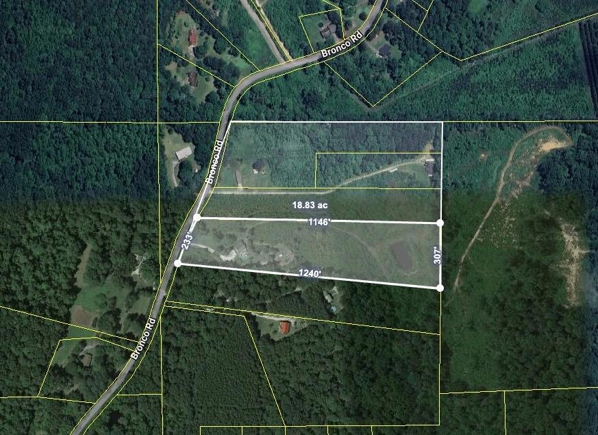
Discover a rare chance to acquire a strategically located three-parcel bundle in the growing LaFayette, GA market. This offering presents tremendous flexibility and is well-suited for portfolio investors, builders, and developers seeking their next profitable project. Collectively, these parcels can be assembled with neighboring tracts to create an impressive ±18-acre development opportunity. Each parcel can be sold separately or bundled together. Price per lots: 1263 Bronco Rd - $220,000, 1227 Bronco Rd - $99,000, and 1225 Bronco Rd - $94,500
Home Details
Home Type
- Single Family
Est. Annual Taxes
- $1,831
Year Built
- Built in 2002
Lot Details
- 5.71 Acre Lot
- Lot Dimensions are 233 x 1240
- Property fronts a county road
- Additional Parcels
Parking
- Gravel Driveway
Home Design
- Fixer Upper
- Block Foundation
- Vinyl Siding
- HardiePlank Type
- Block And Beam Construction
Interior Spaces
- 1,280 Sq Ft Home
- 1-Story Property
- Den
Bedrooms and Bathrooms
- 3 Bedrooms
- 2 Full Bathrooms
Outdoor Features
- Above Ground Pool
- Pond
Schools
- Gilbert Elementary School
- Lafayette Middle School
- Lafayette High School
Utilities
- Window Unit Cooling System
- Central Air
- Septic Tank
- Cable TV Available
Community Details
- No Home Owners Association
Listing and Financial Details
- Assessor Parcel Number 0465 083a
Map
Home Values in the Area
Average Home Value in this Area
Tax History
| Year | Tax Paid | Tax Assessment Tax Assessment Total Assessment is a certain percentage of the fair market value that is determined by local assessors to be the total taxable value of land and additions on the property. | Land | Improvement |
|---|---|---|---|---|
| 2024 | $2,010 | $90,130 | $25,320 | $64,810 |
| 2023 | $1,403 | $1,460 | $0 | $1,460 |
| 2022 | $1,531 | $60,370 | $10,184 | $50,186 |
| 2021 | $1,264 | $44,178 | $10,184 | $33,994 |
| 2020 | $1,115 | $36,985 | $10,184 | $26,801 |
| 2019 | $1,135 | $36,985 | $10,184 | $26,801 |
| 2018 | $979 | $36,985 | $10,184 | $26,801 |
| 2017 | $1,236 | $36,985 | $10,184 | $26,801 |
| 2016 | $1,035 | $36,985 | $10,184 | $26,801 |
| 2015 | $1,129 | $38,358 | $12,592 | $25,766 |
| 2014 | $1,033 | $38,358 | $12,592 | $25,766 |
| 2013 | -- | $38,357 | $12,592 | $25,765 |
Property History
| Date | Event | Price | List to Sale | Price per Sq Ft |
|---|---|---|---|---|
| 12/01/2025 12/01/25 | For Sale | $413,500 | -- | $323 / Sq Ft |
Purchase History
| Date | Type | Sale Price | Title Company |
|---|---|---|---|
| Warranty Deed | $89,000 | -- | |
| Deed | -- | -- | |
| Deed | $10,000 | -- | |
| Deed | $93,000 | -- | |
| Deed | $13,500 | -- |
Source: Greater Chattanooga REALTORS®
MLS Number: 1524666
APN: 0465-083A
Disclaimer: Certain information contained herein is derived from information provided by parties other than Homes.com. All information provided is deemed reliable, but is not guaranteed to be accurate and should be independently verified.
![]() IDX information is provided exclusively for consumers’ personal, noncommercial use, that it may not be used for any purpose other than to identify prospective properties consumers may be interested in purchasing.
IDX information is provided exclusively for consumers’ personal, noncommercial use, that it may not be used for any purpose other than to identify prospective properties consumers may be interested in purchasing.
Data is deemed reliable but is not guaranteed accurate by the MLS.
Ten-X does not display the entire MLS of Chattanooga, Inc. database on this website. The listings of some real estate brokerage firms have been excluded. Some or all of the listings displayed may not belong to the firm whose website is being visited
Copyright© 2025 by Chattanooga Association of REALTORS®
- 334 S Oakland Dr
- 0 Ga Hwy 337 Unit LotWP001
- 1152 Magnolia St
- 100 Lake Terrace Dr
- Curtis Plan at Lake Terrace
- Perry Plan at Lake Terrace
- Edmon Plan at Lake Terrace
- Lewis Plan at Lake Terrace
- Wyeth Plan at Lake Terrace
- Sullivan Plan at Lake Terrace
- 1125 S Chattanooga St
- 221 Chota Cir
- 24605 Highway 193
- 1122 S Chattanooga St
- 908 Gilbert Ln
- 906 S Chattanooga St
- 805 Daugherty St
- 802 Mclemore St
- 712 Mclemore St
- 705 Mclemore St
- 51 Lake Terrace Dr
- 4582 Highway N 27
- 1654 Old Hwy 27
- 73 Muskett Dr
- 8 Kay Dr
- 60 Milton Cir
- 324 Avenue of The Oaks
- 876 Childress Hollow Rd
- 1185 Johnson Rd Unit Johnson
- 607 Castle Dr
- 3438 E Ave
- 34 And 38 E Ave
- 5 Overlook Trail
- 510 Mission Ridge Rd
- 4575 Georgia 136
- 181 East Ave
- 153 Saddlebred Way
- 410 Sam Love Rd
- 57 Tranquility Dr
- 3434 Boynton Dr
