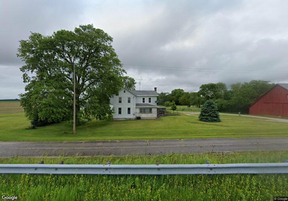
12637 E 1400 North Rd Pontiac, IL 61764
Estimated Value: $252,411 - $278,000
3
Beds
1
Bath
2,191
Sq Ft
$121/Sq Ft
Est. Value
About This Home
This home is located at 12637 E 1400 North Rd, Pontiac, IL 61764 and is currently estimated at $264,603, approximately $120 per square foot. 12637 E 1400 North Rd is a home located in Livingston County with nearby schools including Central Elementary School, Lincoln Elementary School, and Washington Elementary School.
Ownership History
Date
Name
Owned For
Owner Type
Purchase Details
Closed on
Jun 1, 2016
Sold by
Dooley Diana R and Dooley Mark A
Bought by
Robert L Nylander Living Trust
Current Estimated Value
Purchase Details
Closed on
Mar 31, 2010
Sold by
Bauman Jason S and Bauman Amy R
Bought by
Dooley Mark A and Dooley Diana R
Home Financials for this Owner
Home Financials are based on the most recent Mortgage that was taken out on this home.
Original Mortgage
$100,000
Interest Rate
5.03%
Mortgage Type
Stand Alone First
Create a Home Valuation Report for This Property
The Home Valuation Report is an in-depth analysis detailing your home's value as well as a comparison with similar homes in the area
Home Values in the Area
Average Home Value in this Area
Purchase History
| Date | Buyer | Sale Price | Title Company |
|---|---|---|---|
| Robert L Nylander Living Trust | $185,000 | None Available | |
| Dooley Mark A | $160,000 | -- |
Source: Public Records
Mortgage History
| Date | Status | Borrower | Loan Amount |
|---|---|---|---|
| Previous Owner | Dooley Mark A | $100,000 |
Source: Public Records
Tax History Compared to Growth
Tax History
| Year | Tax Paid | Tax Assessment Tax Assessment Total Assessment is a certain percentage of the fair market value that is determined by local assessors to be the total taxable value of land and additions on the property. | Land | Improvement |
|---|---|---|---|---|
| 2024 | $5,174 | $75,054 | $10,960 | $64,094 |
| 2023 | $4,899 | $68,480 | $10,000 | $58,480 |
| 2022 | $4,659 | $63,284 | $9,217 | $54,067 |
| 2021 | $4,408 | $59,478 | $8,663 | $50,815 |
| 2020 | $4,286 | $56,645 | $8,250 | $48,395 |
| 2019 | $4,373 | $56,645 | $8,250 | $48,395 |
| 2018 | $4,104 | $53,418 | $11,588 | $41,830 |
| 2016 | $3,829 | $50,351 | $10,922 | $39,429 |
| 2015 | $3,581 | $46,795 | $10,151 | $36,644 |
| 2013 | $3,419 | $46,715 | $10,276 | $36,439 |
Source: Public Records
Map
Nearby Homes
- 10642 E 1500 Rd N
- 9416 E 1400 North Rd
- 10735 E 1700 Rd N
- 1304 W Reynolds St
- 1204 W Reynolds St
- 105 Carol Ct Unit C-1
- 406 Carol Ct Unit B2
- 1702 S Plum St
- 126 E Diller St
- 1810 Cardinal Ct
- 811 W South St
- 110 W Olive St
- 1620 Meadowlark Dr
- 2 W Edgewood Dr
- 1635 Mockingbird Ln
- 721 W South St
- 119 W Lowell Ave
- 734 W Henry St
- 615 W South St
- 219 W Bennett St