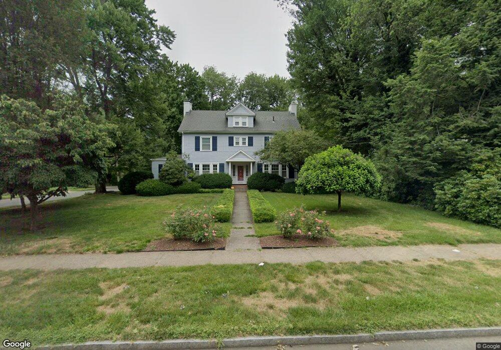
1264 Boulevard West Hartford, CT 06119
Estimated Value: $779,759 - $919,000
5
Beds
5
Baths
3,287
Sq Ft
$261/Sq Ft
Est. Value
About This Home
This home is located at 1264 Boulevard, West Hartford, CT 06119 and is currently estimated at $858,940, approximately $261 per square foot. 1264 Boulevard is a home located in Hartford County with nearby schools including Whiting Lane School, Adams Elementary School, and King Philip Middle School.
Ownership History
Date
Name
Owned For
Owner Type
Purchase Details
Closed on
Aug 11, 2004
Sold by
Geerlings Alicia B and Geerlings Maurits W
Bought by
Doyle Thaddeus A and Doyle Amy W
Current Estimated Value
Purchase Details
Closed on
Feb 14, 2003
Sold by
Piper Mitchell D and Blowers-Piper Robin L
Bought by
Geerlings Maurits W and Geerlings Alicia B
Purchase Details
Closed on
Nov 22, 1999
Sold by
Cardwell Jeanne
Bought by
Piper Mitchell Drew and Blowers-Piper Robin L
Create a Home Valuation Report for This Property
The Home Valuation Report is an in-depth analysis detailing your home's value as well as a comparison with similar homes in the area
Home Values in the Area
Average Home Value in this Area
Purchase History
| Date | Buyer | Sale Price | Title Company |
|---|---|---|---|
| Doyle Thaddeus A | $516,000 | -- | |
| Geerlings Maurits W | $410,000 | -- | |
| Piper Mitchell Drew | $248,000 | -- |
Source: Public Records
Mortgage History
| Date | Status | Borrower | Loan Amount |
|---|---|---|---|
| Open | Piper Mitchell Drew | $415,128 | |
| Closed | Piper Mitchell Drew | $309,100 |
Source: Public Records
Tax History Compared to Growth
Tax History
| Year | Tax Paid | Tax Assessment Tax Assessment Total Assessment is a certain percentage of the fair market value that is determined by local assessors to be the total taxable value of land and additions on the property. | Land | Improvement |
|---|---|---|---|---|
| 2025 | $15,805 | $352,950 | $90,800 | $262,150 |
| 2024 | $14,947 | $352,950 | $90,800 | $262,150 |
| 2023 | $14,443 | $352,950 | $90,800 | $262,150 |
| 2022 | $14,358 | $352,950 | $90,800 | $262,150 |
| 2021 | $13,731 | $323,680 | $90,800 | $232,880 |
| 2020 | $13,530 | $323,680 | $85,600 | $238,080 |
| 2019 | $13,530 | $323,680 | $85,610 | $238,070 |
| 2018 | $13,271 | $323,680 | $85,610 | $238,070 |
| 2017 | $13,284 | $323,680 | $85,610 | $238,070 |
| 2016 | $10,825 | $273,980 | $85,750 | $188,230 |
| 2015 | $10,496 | $273,980 | $85,750 | $188,230 |
| 2014 | $10,239 | $273,980 | $85,750 | $188,230 |
Source: Public Records
Map
Nearby Homes
- 287 Whiting Ln
- 39 Fairlawn St
- 89 Price Blvd
- 16 Lilley Rd
- 102 Oakwood Ave Unit B5
- 30 Outlook Ave Unit 205
- 16 Lockwood Terrace
- 48 Walkley Rd
- 50 Acadia St
- 21 Warren Terrace
- 869 Farmington Ave Unit 305
- 478 Prospect Ave
- 518 Prospect Ave
- 520 Prospect Ave
- 72 Saint Charles St
- 136 Kane St Unit B10
- 54 Robin Rd Unit B2
- 100 Kane St Unit D10
- 90-92 Rowe Ave
- 237 Fern St Unit 314