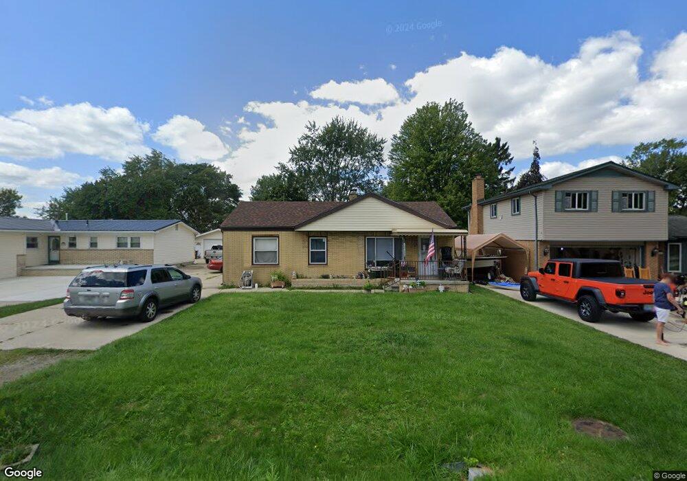
12640 Devoe St Southgate, MI 48195
Estimated Value: $145,000 - $196,000
3
Beds
1
Bath
1,119
Sq Ft
$154/Sq Ft
Est. Value
About This Home
This home is located at 12640 Devoe St, Southgate, MI 48195 and is currently estimated at $172,500, approximately $154 per square foot. 12640 Devoe St is a home located in Wayne County with nearby schools including Shelters Elementary School, Davidson Middle School, and Southgate Anderson High School.
Ownership History
Date
Name
Owned For
Owner Type
Purchase Details
Closed on
Jul 19, 2010
Sold by
Donovan Shaun
Bought by
Gutierrez Carlos P and Gutierrez Mary P
Current Estimated Value
Purchase Details
Closed on
Dec 21, 2009
Sold by
Wells Fargo Bank Na
Bought by
The Secretary Of Housing & Urban Develop
Purchase Details
Closed on
Nov 18, 2009
Sold by
Burks Katholene M and Raths Patricia M
Bought by
Wells Fargo Bank Na
Purchase Details
Closed on
Jul 1, 2005
Sold by
Arini Benedict and Arini Joan
Bought by
Burks Katholene M
Create a Home Valuation Report for This Property
The Home Valuation Report is an in-depth analysis detailing your home's value as well as a comparison with similar homes in the area
Home Values in the Area
Average Home Value in this Area
Purchase History
| Date | Buyer | Sale Price | Title Company |
|---|---|---|---|
| Gutierrez Carlos P | $35,007 | None Available | |
| The Secretary Of Housing & Urban Develop | -- | None Available | |
| Wells Fargo Bank Na | $118,659 | None Available | |
| Burks Katholene M | $120,000 | Multiple |
Source: Public Records
Tax History
| Year | Tax Paid | Tax Assessment Tax Assessment Total Assessment is a certain percentage of the fair market value that is determined by local assessors to be the total taxable value of land and additions on the property. | Land | Improvement |
|---|---|---|---|---|
| 2025 | $2,746 | $70,900 | $0 | $0 |
| 2024 | $2,633 | $64,200 | $0 | $0 |
| 2023 | $2,498 | $56,900 | $0 | $0 |
| 2022 | $2,738 | $52,000 | $0 | $0 |
| 2021 | $2,665 | $47,000 | $0 | $0 |
| 2020 | $2,626 | $46,100 | $0 | $0 |
| 2019 | $2,591 | $41,800 | $0 | $0 |
| 2018 | $2,129 | $35,100 | $0 | $0 |
| 2017 | $850 | $34,400 | $0 | $0 |
| 2016 | $2,419 | $33,800 | $0 | $0 |
| 2015 | $3,014 | $32,100 | $0 | $0 |
| 2013 | $2,920 | $30,400 | $0 | $0 |
| 2012 | $1,998 | $28,700 | $7,400 | $21,300 |
Source: Public Records
Map
Nearby Homes
- 15602 Northline Rd
- 12750 Churchill Ave
- 12690 Churchill Ave
- 12630 Churchill Ave
- 12071 Devoe St
- 13407 Shire Ln Unit 27
- 13419 Shire Ln Unit 26
- 15405 Oakleigh
- 15405 Heatherwood
- 12661 Fordline St
- 16685 Rudgate St
- 13621 Mulberry St
- 13620 Poplar St
- 13367 Fordline St
- 12487 First Ave S
- 12421 Helen St
- 16285 Raleigh Square Dr
- 12100 Helen St
- 4241 Fordline Rd
- 14212 Northline Rd
Your Personal Tour Guide
Ask me questions while you tour the home.