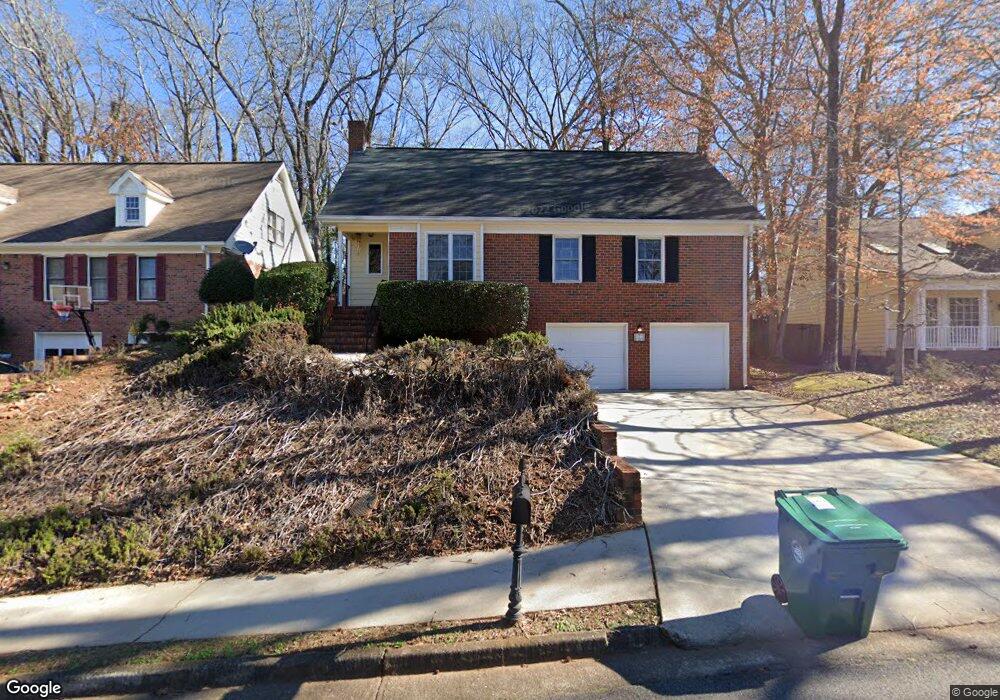
1265 Country Address Unit 1 Clarkston, GA 30021
Estimated Value: $313,805 - $383,000
3
Beds
2
Baths
1,752
Sq Ft
$201/Sq Ft
Est. Value
About This Home
This home is located at 1265 Country Address Unit 1, Clarkston, GA 30021 and is currently estimated at $352,951, approximately $201 per square foot. 1265 Country Address Unit 1 is a home located in DeKalb County with nearby schools including Jolly Elementary School, Freedom Middle School, and Clarkston High School.
Ownership History
Date
Name
Owned For
Owner Type
Purchase Details
Closed on
Jul 8, 1994
Sold by
Strickland Brant R
Bought by
Snyder Kathie L
Current Estimated Value
Purchase Details
Closed on
Apr 26, 1993
Sold by
Harris David A
Bought by
Strickland Brent R Kathie L
Home Financials for this Owner
Home Financials are based on the most recent Mortgage that was taken out on this home.
Original Mortgage
$83,300
Interest Rate
7.51%
Create a Home Valuation Report for This Property
The Home Valuation Report is an in-depth analysis detailing your home's value as well as a comparison with similar homes in the area
Home Values in the Area
Average Home Value in this Area
Purchase History
| Date | Buyer | Sale Price | Title Company |
|---|---|---|---|
| Snyder Kathie L | $4,700 | -- | |
| Strickland Brent R Kathie L | $92,600 | -- |
Source: Public Records
Mortgage History
| Date | Status | Borrower | Loan Amount |
|---|---|---|---|
| Previous Owner | Strickland Brent R Kathie L | $83,300 |
Source: Public Records
Tax History Compared to Growth
Tax History
| Year | Tax Paid | Tax Assessment Tax Assessment Total Assessment is a certain percentage of the fair market value that is determined by local assessors to be the total taxable value of land and additions on the property. | Land | Improvement |
|---|---|---|---|---|
| 2025 | $872 | $125,040 | $32,000 | $93,040 |
| 2024 | $937 | $94,680 | $20,000 | $74,680 |
| 2023 | $937 | $94,680 | $20,000 | $74,680 |
| 2022 | $2,516 | $100,840 | $20,000 | $80,840 |
| 2021 | $2,516 | $82,360 | $20,000 | $62,360 |
| 2020 | $1,985 | $59,960 | $10,840 | $49,120 |
| 2019 | $1,964 | $59,960 | $10,840 | $49,120 |
| 2018 | $1,593 | $60,760 | $10,840 | $49,920 |
| 2017 | $1,817 | $53,840 | $10,840 | $43,000 |
| 2016 | $1,772 | $53,840 | $10,840 | $43,000 |
| 2014 | $1,461 | $45,000 | $10,840 | $34,160 |
Source: Public Records
Map
Nearby Homes
- 1172 Denison Dr
- 4549 Erskine Rd
- 3816 Prescott Ridge Cir Unit 30
- 1310 Brockett Place
- 1362 Brockett Place Unit 1362
- 1297 Tree Creek Ct
- 1111 Gunnison Ct Unit 4
- 1367 Wenlock Edge Cove
- 3965 Camelot Ct
- 4074 Idlevale Dr
- 1399 Sagewood Cir
- 957 Texel Ln Unit 4
- 3647 Cobble Mill Ln Unit Ste B4
- 1092 Alpco Ct
- 4245 Parkview Ct Unit H
- 4166 Idlevale Dr
- 4252 Parkview Ct
- 4263 Parkview Ct
- 4191 Central Dr
- 1343 Orchard Park Dr
- 1269 Country Address Unit 1
- 1261 Country Address
- 1257 Country Address Unit 1
- 1273 Country Address Unit 1
- 3968 Back Trail
- 1253 Country Address
- 1268 Country Address Unit 1
- 1268 Country Address
- 1277 Country Address
- 1272 Country Address
- 3962 Back Trail Unit 1
- 1249 Country Address Unit 1
- 1252 Country Address
- 3971 Clayhill
- 1281 Country Address
- 3958 Back Trail
- 1245 Country Address Unit 1
- 0 Back Trail Unit 3194282
- 3963 Back Trail
- 3965 Clayhill Unit 1