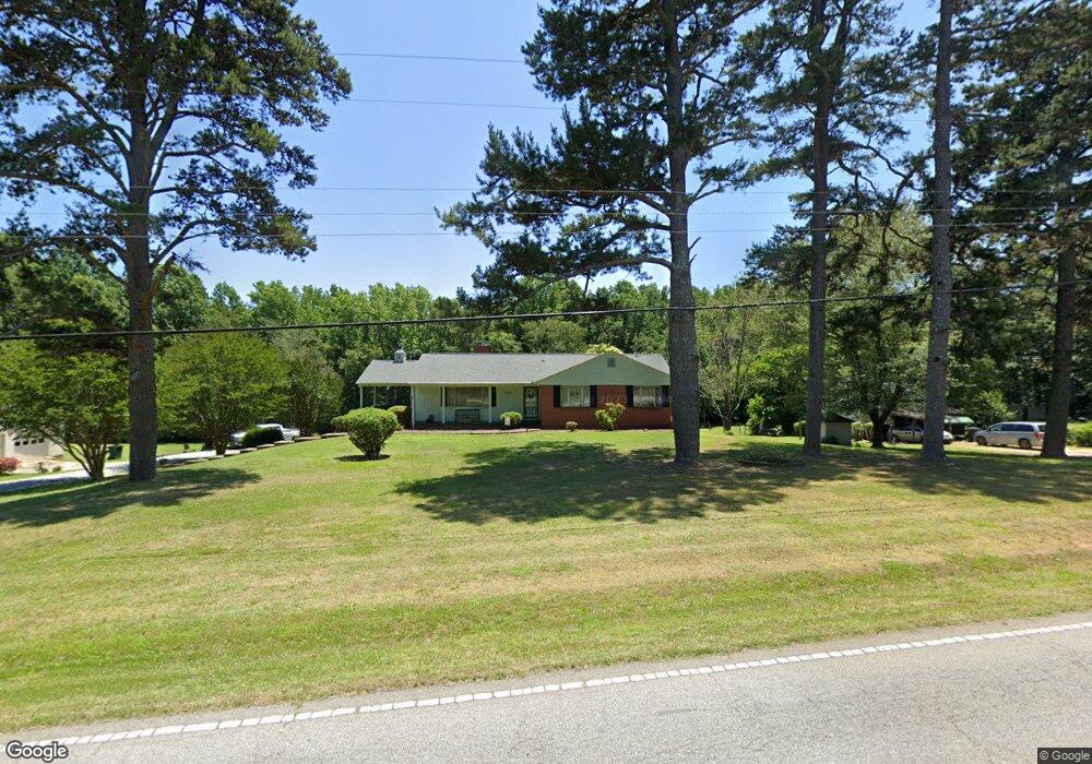
1265 E Ridge Rd Salisbury, NC 28144
Estimated Value: $249,000 - $335,000
Studio
2
Baths
1,536
Sq Ft
$189/Sq Ft
Est. Value
About This Home
This home is located at 1265 E Ridge Rd, Salisbury, NC 28144 and is currently estimated at $289,914, approximately $188 per square foot. 1265 E Ridge Rd is a home located in Rowan County with nearby schools including North Rowan Elementary School, North Rowan Middle School, and North Rowan High School.
Ownership History
Date
Name
Owned For
Owner Type
Purchase Details
Closed on
May 12, 2023
Sold by
Kennerly Charles Robert and Kennerly Judy Blevins
Bought by
Taylor Rabon Edward and Kennerly Rabon Ruth
Current Estimated Value
Purchase Details
Closed on
Dec 6, 2013
Sold by
Kennerly Charles Robert and Kennerly Judy Blevins
Bought by
Kennerly Charles Robert and Kennerly Judy Blevins
Purchase Details
Closed on
Nov 19, 2010
Sold by
Kennerly Charles R and Kennerly Judy
Bought by
Hardy Wendy Pruell
Create a Home Valuation Report for This Property
The Home Valuation Report is an in-depth analysis detailing your home's value as well as a comparison with similar homes in the area
Purchase History
| Date | Buyer | Sale Price | Title Company |
|---|---|---|---|
| Taylor Rabon Edward | -- | None Listed On Document | |
| Taylor Rabon Edward | -- | None Listed On Document | |
| Kennerly Charles Robert | -- | None Available | |
| Hardy Wendy Pruell | $6,000 | None Available |
Source: Public Records
Tax History
| Year | Tax Paid | Tax Assessment Tax Assessment Total Assessment is a certain percentage of the fair market value that is determined by local assessors to be the total taxable value of land and additions on the property. | Land | Improvement |
|---|---|---|---|---|
| 2025 | $1,902 | $286,054 | $70,236 | $215,818 |
| 2024 | $1,902 | $286,054 | $70,236 | $215,818 |
| 2023 | $1,650 | $248,067 | $70,569 | $177,498 |
| 2022 | $1,277 | $172,039 | $58,962 | $113,077 |
| 2021 | $1,277 | $172,039 | $58,962 | $113,077 |
| 2020 | $1,277 | $172,039 | $58,962 | $113,077 |
| 2019 | $1,277 | $172,039 | $58,962 | $113,077 |
| 2018 | $1,086 | $147,456 | $58,962 | $88,494 |
| 2017 | $1,086 | $147,456 | $58,962 | $88,494 |
| 2016 | $1,086 | $147,456 | $58,962 | $88,494 |
| 2015 | $1,102 | $147,456 | $58,962 | $88,494 |
| 2014 | $1,086 | $151,916 | $58,962 | $92,954 |
Source: Public Records
Map
Nearby Homes
- 350 Pinevale Dr
- 250 Lariat Cir
- 140 Elizabeth Ave
- 235 Lariat Cir
- 255 Lariat Cir
- 450 E Ridge Rd
- 250 Douglas St
- 470 Nestlewood Ln
- 605 Bonanza Dr
- 240 Eldon Ln
- 307 Pantego Place
- 4355 Franklin Community Center Rd
- 430 Old Wood Ln
- Chandler Basement Plan at Oxford Station
- Rockwell Plan at Oxford Station
- Manchester Plan at Oxford Station
- Chandler Plan at Oxford Station
- Cottonwood Plan at Oxford Station
- Gibson Plan at Oxford Station
- Sherwood Plan at Oxford Station
- 1275 E Ridge Rd
- 1235 E Ridge Rd
- 1220 E Ridge Rd
- 1260 E Ridge Rd
- 1345 E Ridge Rd
- 1340 E Ridge Rd
- 1145 E Ridge Rd
- 1197 Glock Ct
- 1055 E Ridge Rd
- 1176 Glock Ct
- 1176 Glock Ct Unit NULL
- 1865 Sells Rd
- 1355 E Ridge Rd
- 1045 E Ridge Rd
- 1350 E Ridge Rd
- 1035 E Ridge Rd
- 01 Cauble Rd
- 001 Cauble Rd
- 002 Cauble Rd
- 00 Cauble Rd
Your Personal Tour Guide
Ask me questions while you tour the home.