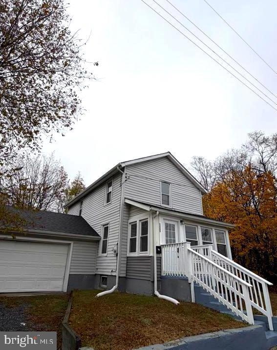
1265 Walter Ave Paulsboro, NJ 08066
Highlights
- Cape Cod Architecture
- 2 Car Attached Garage
- Forced Air Heating and Cooling System
- No HOA
About This Home
Beautiful 3-bedroom, 2-bathroom, 2-story home with a 2-car garage in an excellent location! This property features a spacious, fully fenced yard, a basement, and numerous recent updates, including new flooring, a new stove, and a new refrigerator. The home offers large, airy rooms, a bright kitchen, and a fantastic lot perfect for outdoor living. Gas heating ensures comfort year-round. Financial Aid/Section 8 is always accepted! You and/or your group's average Credit Score (including Cosigners) has to be at least 650 or higher, even with rental assistance/housing vouchers. If you do not have a Credit Score, then you automatically need a Cosigner. You and/or your group’s total Net Income per week must be equal to or greater than the rent price per month, or your rental assistance/housing voucher has to cover the monthly rent Available Immediately – Don’t miss out!

Home Details
Home Type
- Single Family
Est. Annual Taxes
- $3,344
Year Built
- Built in 1920
Lot Details
- 10,376 Sq Ft Lot
- Lot Dimensions are 78.00 x 133.00
- Property is zoned R1
Parking
- 2 Car Attached Garage
- Front Facing Garage
- Driveway
Home Design
- Cape Cod Architecture
- Combination Foundation
- Frame Construction
Interior Spaces
- 1,176 Sq Ft Home
- Property has 2 Levels
- Laundry on main level
- Basement
Bedrooms and Bathrooms
- 3 Main Level Bedrooms
- 2 Full Bathrooms
Utilities
- Forced Air Heating and Cooling System
- Natural Gas Water Heater
Listing and Financial Details
- Residential Lease
- Security Deposit $3,600
- Tenant pays for all utilities
- No Smoking Allowed
- 12-Month Min and 24-Month Max Lease Term
- Available 12/1/25
- $35 Application Fee
- Assessor Parcel Number 14-00121-00021
Community Details
Overview
- No Home Owners Association
Pet Policy
- No Pets Allowed
Map
Source: Bright MLS
MLS Number: NJGL2066812
APN: 14-00121-0000-00021
Disclaimer: Certain information contained herein is derived from information provided by parties other than Homes.com. All information provided is deemed reliable, but is not guaranteed to be accurate and should be independently verified.
![]() The data relating to real estate for sale on this website appears in part through the BRIGHT Internet Data Exchange program, a voluntary cooperative exchange of property listing data between licensed real estate brokerage firms, and is provided by BRIGHT through a licensing agreement.
The data relating to real estate for sale on this website appears in part through the BRIGHT Internet Data Exchange program, a voluntary cooperative exchange of property listing data between licensed real estate brokerage firms, and is provided by BRIGHT through a licensing agreement.
Listing information is from various brokers who participate in the Bright MLS IDX program and not all listings may be visible on the site.
The property information being provided on or through the website is for the personal, non-commercial use of consumers and such information may not be used for any purpose other than to identify prospective properties consumers may be interested in purchasing.
Some properties which appear for sale on the website may no longer be available because they are for instance, under contract, sold or are no longer being offered for sale.
Property information displayed is deemed reliable but is not guaranteed.
Copyright 2025 Bright MLS, Inc.
- 1214 Walter Ave
- 1224 Heddon Ave
- 0 Lodge Ave
- 131 Jessup St
- 1534 Pine St
- L5 Lodge Ave
- L8 Lodge Ave
- 255 Elizabeth Ave
- 8 S Delaware St
- 1519 Pine St
- 269 W Broad St
- L18 20 W Broad St
- 219 Vanneman Blvd
- 227 W Buck St
- 122 W Washington St
- 330 Croce Ave
- 335 W Buck St
- 344 W Washington St
- 11 W Washington St
- 21 W Adams St
- 108 W Buck St
- 333 W Buck St
- 322 W Washington St
- 218 W Adams St
- 110 W Adams St
- 1105 Kohana Dr
- 648 Beacon Ave Unit 2
- 246 Iannelli Rd
- 16 Berkley Rd
- 17 Higginsville Ln
- 290 Kings Hwy Unit C
- 279 Academy St
- 107 River Road Dr
- 107 River Rd Dr
- 262 Crown Point Rd Unit A
- 1032 Moore Rd
- 14 Highbridge Ln Unit 14
- 4000 Forest Creek Ln
- 117 Lionheart Ln Unit D117
- 968 Kings Hwy