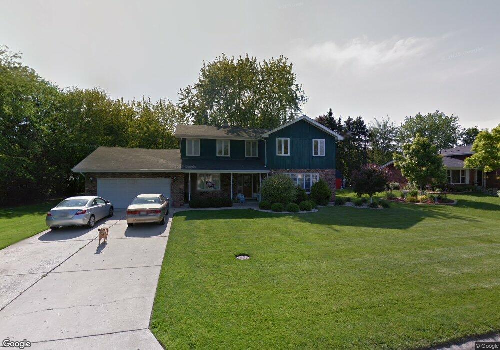
12650 E Navajo Dr Palos Heights, IL 60463
Navajo Hills NeighborhoodEstimated Value: $468,804 - $488,000
4
Beds
3
Baths
2,238
Sq Ft
$215/Sq Ft
Est. Value
About This Home
This home is located at 12650 E Navajo Dr, Palos Heights, IL 60463 and is currently estimated at $481,451, approximately $215 per square foot. 12650 E Navajo Dr is a home located in Cook County with nearby schools including Navajo Heights Elementary School, Chippewa Elementary School, and Independence Jr High School.
Ownership History
Date
Name
Owned For
Owner Type
Purchase Details
Closed on
Jul 24, 2025
Sold by
Prestinario James M and Prestinario Joanne M
Bought by
Stephen Siller Tunnel To Towers Foundation
Current Estimated Value
Purchase Details
Closed on
Apr 30, 2015
Sold by
King Aurelie A
Bought by
Prestinario James M and Prestinario Joanne M
Create a Home Valuation Report for This Property
The Home Valuation Report is an in-depth analysis detailing your home's value as well as a comparison with similar homes in the area
Home Values in the Area
Average Home Value in this Area
Purchase History
| Date | Buyer | Sale Price | Title Company |
|---|---|---|---|
| Stephen Siller Tunnel To Towers Foundation | $485,000 | Chicago Title | |
| Prestinario James M | $200,000 | Attorneys Title Guaranty Fun |
Source: Public Records
Tax History Compared to Growth
Tax History
| Year | Tax Paid | Tax Assessment Tax Assessment Total Assessment is a certain percentage of the fair market value that is determined by local assessors to be the total taxable value of land and additions on the property. | Land | Improvement |
|---|---|---|---|---|
| 2024 | $6,342 | $35,000 | $7,664 | $27,336 |
| 2023 | $7,558 | $35,000 | $7,664 | $27,336 |
| 2022 | $7,558 | $27,772 | $6,744 | $21,028 |
| 2021 | $7,279 | $27,772 | $6,744 | $21,028 |
| 2020 | $7,505 | $27,772 | $6,744 | $21,028 |
| 2019 | $7,549 | $28,959 | $6,131 | $22,828 |
| 2018 | $7,144 | $28,959 | $6,131 | $22,828 |
| 2017 | $8,582 | $33,460 | $6,131 | $27,329 |
| 2016 | $6,968 | $25,487 | $5,211 | $20,276 |
| 2015 | $7,286 | $27,143 | $5,211 | $21,932 |
| 2014 | $8,478 | $27,143 | $5,211 | $21,932 |
| 2013 | -- | $30,256 | $5,211 | $25,045 |
Source: Public Records
Map
Nearby Homes
- 6711 W Shiawassie Dr
- 12753 S Oak Park Ave
- 12611 Natoma Ave
- 6839 W 127th St
- 6519 W 126th Place
- 6709 W Menominee Pkwy
- 12646 S 69th Ct
- 12718 S 69th Ct
- 12722 S 69th Ct
- 13007 S Oak Park Ave
- 12422 S 70th Ct
- 12501 S 71st Ct
- 430 Shadow Creek Dr
- 12815 S Seneca Rd
- 12246 S Nagle Ave
- 7309 W Palos Ave
- 12900 S Seneca Rd
- 13064 S 71st Ave
- 13097 Laurel Glen Ct Unit 202
- 6052 W 128th St
- 12634 W Navajo Dr
- 12645 S Navajo Ct W
- 12635 S Navajo Ct W
- 6721 W Navajo Dr
- 12643 E Navajo Dr
- 12705 S Auburn Ave
- 6723 W Navajo Dr
- 12700 S Auburn Ave
- 6701 W Navajo Dr
- 12700 S Westgate Dr
- 12711 S Auburn Ave
- 99999 Confidential St
- 99991 Confidential Ave
- 9999 S Confidential Ave
- 9999 Confidential
- 999 W Confidential St
- 999 Confidential
- 0000 Confidential
- 12651 S Navajo Ct W
- 12634 S Navajo Ct E