Estimated Value: $180,000 - $242,061
2
Beds
2
Baths
969
Sq Ft
$219/Sq Ft
Est. Value
About This Home
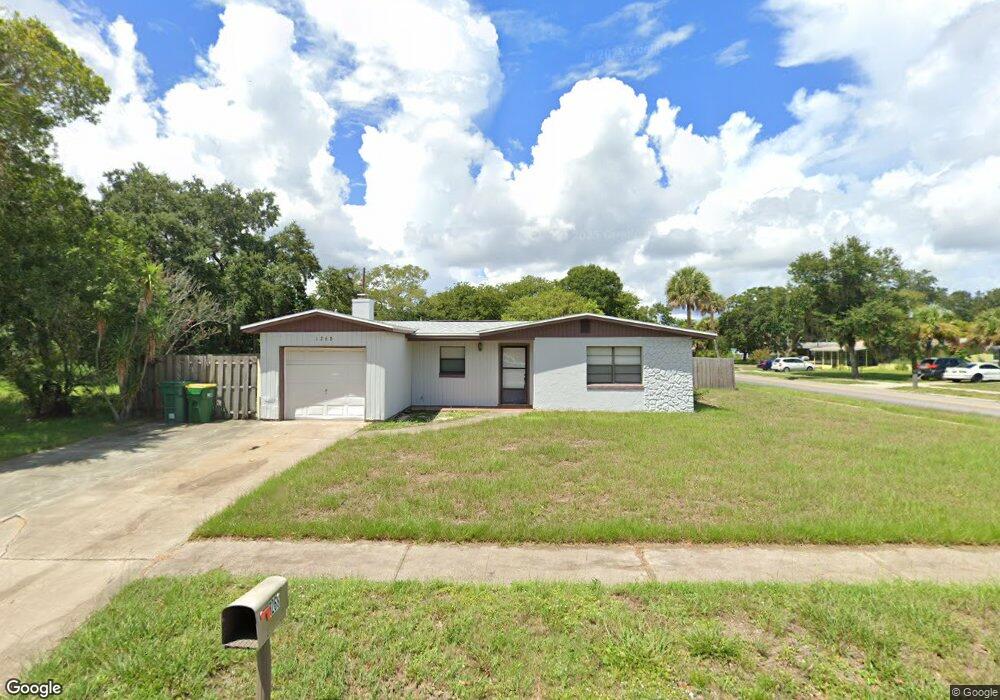
This home is located at 1268 Amherst Ct, Cocoa, FL 32922 and is currently estimated at $212,015, approximately $218 per square foot. 1268 Amherst Ct is a home located in Brevard County with nearby schools including Cocoa High School, Saturn Elementary School, and Emma Jewel Charter Academy.
Ownership History
Date
Name
Owned For
Owner Type
Purchase Details
Closed on
Sep 13, 2024
Sold by
1268 Amherst Court Trust and Comodore Management Llc
Bought by
1268 Amherst Court Trust and Minot
Current Estimated Value
Purchase Details
Closed on
Oct 17, 2013
Sold by
Parish Joseph W
Bought by
Comodore Management Llc and The 1268 Amherst Court Trust
Purchase Details
Closed on
Aug 31, 2004
Sold by
Fisher Earl D and Fisher Elizabeth D
Bought by
Parish Joseph W
Home Financials for this Owner
Home Financials are based on the most recent Mortgage that was taken out on this home.
Original Mortgage
$96,000
Interest Rate
8.05%
Create a Home Valuation Report for This Property
The Home Valuation Report is an in-depth analysis detailing your home's value as well as a comparison with similar homes in the area
Home Values in the Area
Average Home Value in this Area
Purchase History
| Date | Buyer | Sale Price | Title Company |
|---|---|---|---|
| 1268 Amherst Court Trust | $100 | None Listed On Document | |
| Comodore Management Llc | $19,000 | None Available | |
| Parish Joseph W | $120,000 | Island Title & Escrow Corp |
Source: Public Records
Mortgage History
| Date | Status | Borrower | Loan Amount |
|---|---|---|---|
| Previous Owner | Parish Joseph W | $96,000 | |
| Closed | Parish Joseph W | $24,000 |
Source: Public Records
Tax History
| Year | Tax Paid | Tax Assessment Tax Assessment Total Assessment is a certain percentage of the fair market value that is determined by local assessors to be the total taxable value of land and additions on the property. | Land | Improvement |
|---|---|---|---|---|
| 2025 | $2,794 | $205,700 | -- | -- |
| 2024 | $2,512 | $200,970 | -- | -- |
| 2023 | $2,512 | $169,160 | $0 | $0 |
| 2022 | $2,141 | $150,590 | $0 | $0 |
| 2021 | $1,797 | $93,970 | $36,000 | $57,970 |
| 2020 | $1,627 | $82,090 | $36,000 | $46,090 |
| 2019 | $1,575 | $83,070 | $36,000 | $47,070 |
| 2018 | $1,358 | $72,570 | $25,000 | $47,570 |
| 2017 | $1,215 | $55,350 | $17,000 | $38,350 |
| 2016 | $1,121 | $46,390 | $9,000 | $37,390 |
| 2015 | $1,047 | $40,740 | $9,000 | $31,740 |
| 2014 | $972 | $39,050 | $10,000 | $29,050 |
Source: Public Records
Map
Nearby Homes
- 1810 Dixon Blvd
- 1711 Dixon Blvd Unit 179
- 1326 Stetson Ct
- 2029 Ivy Dr
- 914 Clearlake Rd Unit 211B
- 914 Clearlake Rd Unit 115B
- 914 Clearlake Rd Unit 208C
- 914 Clearlake Rd Unit 206B
- 1523 Clearlake Ct
- 1686 Ritzcraft St Unit 326
- 1417 Walter St
- 1531 Paradise Ln
- 1703 Spartan St Unit SRO737
- 703 Venus Dr
- 1523 Furnari St
- 1515 Furnari St
- 1644 Ruth St
- 0 University Ln
- 1011 Montclair Rd
- 717 Lunar Lake Cir
- 1264 Amherst Ct
- 1827 Dixon Blvd
- 1822 Dixon Blvd
- 1820 Dixon Blvd
- 1260 Amherst Ct
- 1267 Amherst Ct
- 1263 Amherst Ct
- 1824 Dixon Blvd
- 1818 Dixon Blvd
- 1259 Amherst Ct
- 1256 Amherst Ct
- 1805 Baylor Ct
- 1809 Baylor Ct
- 1814 Dixon Blvd
- 1203 Amherst Ct
- 1801 Baylor Ct
- 1813 Baylor Ct
- 1253 Amherst Ct
- 1207 Amherst Ct
- 1252 Amherst Ct
Your Personal Tour Guide
Ask me questions while you tour the home.