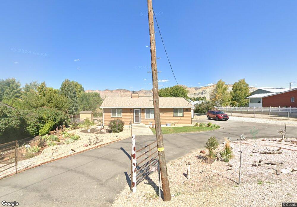
1268 W 3500 N Helper, UT 84526
Estimated Value: $299,000 - $387,000
3
Beds
2
Baths
1,260
Sq Ft
$272/Sq Ft
Est. Value
About This Home
This home is located at 1268 W 3500 N, Helper, UT 84526 and is currently estimated at $342,718, approximately $271 per square foot. 1268 W 3500 N is a home located in Carbon County with nearby schools including Sally Mauro School, Helper Middle School, and Carbon High School.
Ownership History
Date
Name
Owned For
Owner Type
Purchase Details
Closed on
Dec 29, 2021
Sold by
Roundy Louretta P and Prettyman Louretta
Bought by
Prettyman Louretta
Current Estimated Value
Purchase Details
Closed on
Sep 8, 2017
Sold by
Westenskow Evan and Westenskow Megan
Bought by
Roundy Louretta P
Home Financials for this Owner
Home Financials are based on the most recent Mortgage that was taken out on this home.
Original Mortgage
$133,860
Outstanding Balance
$110,767
Interest Rate
3.92%
Mortgage Type
New Conventional
Estimated Equity
$231,951
Purchase Details
Closed on
Jun 16, 2014
Sold by
Pero Robert P and Pero Dominic R
Bought by
Westenskow Evan and Westenskow Megan
Home Financials for this Owner
Home Financials are based on the most recent Mortgage that was taken out on this home.
Original Mortgage
$143,877
Interest Rate
4.1%
Mortgage Type
New Conventional
Create a Home Valuation Report for This Property
The Home Valuation Report is an in-depth analysis detailing your home's value as well as a comparison with similar homes in the area
Purchase History
| Date | Buyer | Sale Price | Title Company |
|---|---|---|---|
| Prettyman Louretta | -- | None Available | |
| Roundy Louretta P | -- | South Eastern Utah Title Co | |
| Westenskow Evan | -- | Professional Title Services |
Source: Public Records
Mortgage History
| Date | Status | Borrower | Loan Amount |
|---|---|---|---|
| Open | Roundy Louretta P | $133,860 | |
| Previous Owner | Westenskow Evan | $143,877 |
Source: Public Records
Tax History
| Year | Tax Paid | Tax Assessment Tax Assessment Total Assessment is a certain percentage of the fair market value that is determined by local assessors to be the total taxable value of land and additions on the property. | Land | Improvement |
|---|---|---|---|---|
| 2025 | $2,065 | $159,893 | $30,291 | $129,602 |
| 2024 | $1,549 | $122,047 | $34,045 | $88,002 |
| 2023 | $1,569 | $133,466 | $24,750 | $108,716 |
| 2022 | $1,507 | $113,519 | $19,860 | $93,660 |
| 2021 | $1,393 | $166,451 | $29,120 | $137,331 |
| 2020 | $1,228 | $73,541 | $0 | $0 |
| 2019 | $902 | $66,047 | $0 | $0 |
| 2018 | $877 | $66,047 | $0 | $0 |
| 2017 | $864 | $66,042 | $0 | $0 |
| 2016 | $773 | $66,042 | $0 | $0 |
| 2015 | $773 | $66,042 | $0 | $0 |
| 2014 | $761 | $66,042 | $0 | $0 |
| 2013 | $768 | $66,042 | $0 | $0 |
Source: Public Records
Map
Nearby Homes
- 1630 W 4200 N Unit 5
- 2095 W 4100 N
- 1240 W 2360 N
- 1363 Shelby Ln
- 2143 N Carbonville Rd Unit 1
- 2180 N 1950 W
- 2595 Fairway Ln Unit 11
- 1801 W 2000 N
- 564 S 300 W
- 1407 N 1250 W
- 5441 N Eagle Dr
- 338 S 300 W
- 182 S Main St
- 1265 N Carbonville Rd Unit 10
- 1265 N Carbonville Rd Unit 100
- 10 S 100 W
- 1171 W 2330 N
- 2350 N 1075 W
- 1116 N 610 W
- 347 Hill St
Your Personal Tour Guide
Ask me questions while you tour the home.