NOT LISTED FOR SALE

1269 Ruffed Grouse Way Kettle Falls, WA 99141

Estimated Value: $328,000 - $389,000

1.12 Acres
$316,024 Price per Acre
48,787 Sq Ft Lot

Last Sold April 08, 2019

Last sale price $39,500

Est. 796% increase in value since last sale

Current estimated payment $2,057/month

2,963 Days on Market

Highlights

  • Territorial View
  • Landscaped with Trees
  • Level Lot
  • No HOA
  • Spring water is a source of water for the property

About This Lot

As of April 2019

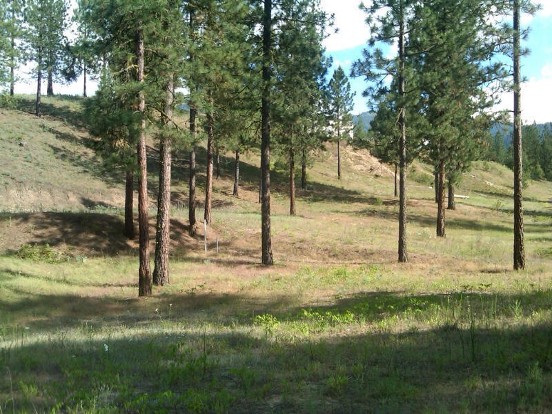
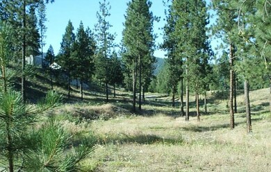
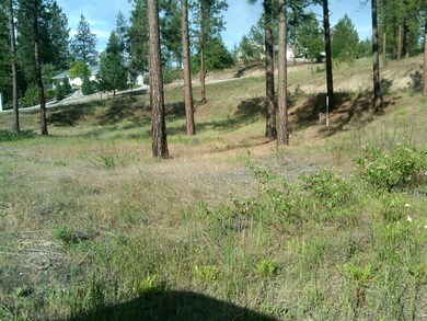
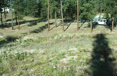
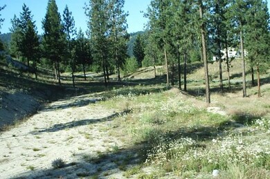
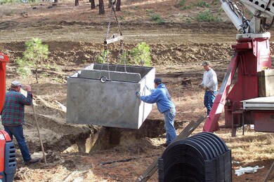
POWER, SEPTIC INSTALLED ,PHONE, CITY WATER CONNECTED TO THIS BUILDING LOT near Lake Roosevelt & the Colville River. 1.12 ACRES connected. Power & phone at the property line. This building site is located in a quiet area 4 miles south-west of Kettle Falls. Easy access and ready to build. Owner contract available.
NO SINGLEWIDES. #23417 $42,500 5-23-2016 BOB JONES SAID MANUFACTURED HOMES ARE OK ON THE PROPERTY, JUST NOT TRAILERS.

Last Listed By

ANADEE SNYDER

WINDERMERE KETTLE FALLS License #2884 Listed on: 09/20/2017

Property Details

Property Type

  • Land

Est. Annual Taxes

  • $350

Lot Details

  • 1.12 Acre Lot
  • Level Lot
  • Landscaped with Trees
  • Property is zoned County

Property Views

  • Territorial Views

Utilities

  • Electricity To Lot Line
  • Spring water is a source of water for the property
  • Septic Design Installed

Community Details

  • No Home Owners Association
  • The community has rules related to covenants, conditions, and restrictions

Listing and Financial Details

  • Assessor Parcel Number 1942081

Property Details

Property Type

Land

Est. Annual Taxes

$350

Lot Details

0

Listing Details

  • Prop. Type: Land
  • Property Sub-Type: Lot
  • Lot Size Acres: 1.12
  • Co List Office Phone: 509-738-6521
  • MLS Status: Closed
  • Accessibility Features: Public Road
  • Tax Year: 2016
  • Master Plan Zoning: County
  • Property Information Waterfront: None
  • Property Information Lot Dimensions: IRREGULAR
  • Property Information # of Acres: 1.12
  • Location Tax Legal:Taxes2: 350.
  • Location Tax Legal Tax Yr: 2016
  • Topography:Level: Yes
  • Topography:Sloped: Yes
  • Property Information Crops: No
  • Property Information CCR'S: Yes
  • Property Information Setting: Subdivision
  • Property Information Borders Govt: No
  • Property Information Mobile Approved: Unknown
  • Property Information Developed Water: Yes
  • View Territorial: Yes
  • Highlights Moderate Trees: Yes
  • Water System Public Water System: Yes
  • Utilities PowerProperty Line: Yes
  • Sewage Septic Installed: Yes
  • Special Features: VirtualTour
  • Property Sub Type: LotsLands

Exterior Features

  • Topography: Sloped, Level
  • View: Territorial

Utilities

  • Water Source: Public

Condo/Co-op/Association

  • Association Fee Frequency: None
  • Association: No

Schools

  • Junior High Dist: Kettle Falls

Lot Info

  • Current Use: Residential
  • Parcel #: 1942081
  • Lot Dimensions: IRREGULAR
  • Lot Size Sq Ft: 48787.2
  • ResoLotSizeUnits: Acres
  • Zoning Description: Residential
  • ResoLotSizeUnits: Acres

Tax Info

  • Tax Annual Amount: 350.0

Ownership History

Date Name Owned For Owner Type

Purchase Details

Listed on
Sep 20, 2017
Closed on
Apr 4, 2019
Sold by
Bartolus James and Bartolus Ruth
Bought by
Beatty Lloyd H and Beatty Marlene S
Seller's Agent
ANADEE SNYDER
WINDERMERE KETTLE FALLS
Buyer's Agent
DEBBIE BAKER
WINDERMERE KETTLE FALLS
List Price
$49,000
Sold Price
$39,500
Premium/Discount to List
-$9,500
-19.39%
Total Days on Market
2963
Current Estimated Value
$353,947

Home Financials for this Owner

Home Financials are based on the most recent Mortgage that was taken out on this home.
Estimated Appreciation
$314,447
Avg. Annual Appreciation
43.60%

Range of Values:

Collateral Analytics

Collateral Analytics Collateral Analytics AVMs (Automated Valuation Model) employ a number of statistical approaches combined with neighborhood-specific comparable selection guarantees the most up-to-date and precise valuations.

Not Available

Collateral Analytics does not have data for the current month. Please view the chart for historical values.

ICE

ICE Mortgage Technology ICE Mortgage Technology’s AVM (Automated Valuation Model) is a state-of-the-art online residential property valuation tool that provides a quick and accurate estimate of the value of almost any home in the U.S.

Not Available

ICE Mortgage Technology does not have data for the current month. Please view the chart for historical values.

First American

First American First American Data & Analytics’ next-generation AVM combines unrivaled data assets with a blended ensemble of valuation models to produce highly accurate, reliable valuations you can trust.

Not Available

First American does not have data for the current month. Please view the chart for historical values.

Quantarium

Quantarium Quantarium’s valuation service, repeatedly proven the industry’s most accurate and comprehensive, is supercharged with a self-learning and auto-tuning AI engine that continually becomes smarter and more accurate as it processes daily inputs from the industry’s leading RE data lake.

Not Available

Quantarium does not have data for the current month. Please view the chart for historical values.

Average Value
Not Available
List Price
Sold Price
Create a Home Valuation Report for This Property
The Home Valuation Report is an in-depth analysis detailing your home's value as well as a comparison with similar homes in the area

Home Values in the Area

Source: Public Records

Average Home Value in this Area


Source: Public Records

Purchase History

Date Buyer Sale Price Title Company
Beatty Lloyd H $39,500 Stevens County Title Company
Source: Public Records

Property History

Date Event Price Change Sq Ft Price
04/08/2019 04/08/19 Sold $39,500 -19.4% --
03/25/2019 03/25/19 Pending -- -- --
02/12/2011 02/12/11 For Sale $49,000 -- --
Source: Northeast Washington Association of REALTORS®

Tax History Compared to Growth

Source: Public Records

Tax History

Year Tax Paid Tax Assessment Tax Assessment Total Assessment is a certain percentage of the fair market value that is determined by local assessors to be the total taxable value of land and additions on the property. Land Improvement
2023 $2,132 $291,255 $40,000 $251,255
2022 $1,928 $271,538 $40,000 $231,538
2021 $339 $39,500 $32,000 $7,500
2020 $337 $39,500 $32,000 $7,500
2019 $312 $39,500 $32,000 $7,500
2018 $370 $37,500 $30,000 $7,500
2017 $338 $37,500 $30,000 $7,500
2016 $345 $37,500 $30,000 $7,500
2015 $327 $37,500 $30,000 $7,500
2013 -- $37,500 $30,000 $7,500
Source: Public Records

Agents Affiliated with this Home

See All Agents

Map

Source: Northeast Washington Association of REALTORS®

MLS Number: 23417

APN: 1942081