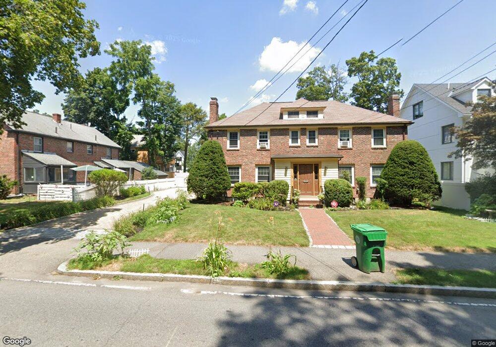
127 Auburn St Unit 129 Auburndale, MA 02466
Auburndale NeighborhoodEstimated Value: $1,242,000 - $1,551,926
4
Beds
3
Baths
2,200
Sq Ft
$639/Sq Ft
Est. Value
About This Home
This home is located at 127 Auburn St Unit 129, Auburndale, MA 02466 and is currently estimated at $1,406,732, approximately $639 per square foot. 127 Auburn St Unit 129 is a home located in Middlesex County with nearby schools including Williams Elementary School, Charles E Brown Middle School, and Newton South High School.
Ownership History
Date
Name
Owned For
Owner Type
Purchase Details
Closed on
Sep 15, 2016
Sold by
Towle Fran L
Bought by
Fran L Towle 2016 Ret
Current Estimated Value
Purchase Details
Closed on
Aug 26, 1992
Sold by
Elizabeth Yuchniewicz
Bought by
Oleary Robert A and Oleary Elizabeth P
Home Financials for this Owner
Home Financials are based on the most recent Mortgage that was taken out on this home.
Original Mortgage
$170,000
Interest Rate
8.09%
Mortgage Type
Purchase Money Mortgage
Purchase Details
Closed on
Aug 1, 1983
Bought by
Towle Fran L
Create a Home Valuation Report for This Property
The Home Valuation Report is an in-depth analysis detailing your home's value as well as a comparison with similar homes in the area
Home Values in the Area
Average Home Value in this Area
Purchase History
| Date | Buyer | Sale Price | Title Company |
|---|---|---|---|
| Fran L Towle 2016 Ret | -- | -- | |
| Oleary Robert A | $75,000 | -- | |
| Towle Fran L | $135,000 | -- |
Source: Public Records
Mortgage History
| Date | Status | Borrower | Loan Amount |
|---|---|---|---|
| Previous Owner | Towle Fran L | $70,000 | |
| Previous Owner | Oleary Robert A | $170,000 |
Source: Public Records
Tax History Compared to Growth
Tax History
| Year | Tax Paid | Tax Assessment Tax Assessment Total Assessment is a certain percentage of the fair market value that is determined by local assessors to be the total taxable value of land and additions on the property. | Land | Improvement |
|---|---|---|---|---|
| 2025 | $11,570 | $1,180,600 | $762,100 | $418,500 |
| 2024 | $11,187 | $1,146,200 | $739,900 | $406,300 |
| 2023 | $10,700 | $1,051,100 | $597,700 | $453,400 |
| 2022 | $10,238 | $973,200 | $553,400 | $419,800 |
| 2021 | $9,607 | $892,800 | $507,700 | $385,100 |
| 2020 | $9,321 | $892,800 | $507,700 | $385,100 |
| 2019 | $8,719 | $834,400 | $474,500 | $359,900 |
| 2018 | $8,686 | $802,800 | $448,300 | $354,500 |
| 2017 | $8,190 | $736,500 | $411,300 | $325,200 |
| 2016 | $7,689 | $675,700 | $377,300 | $298,400 |
| 2015 | $7,332 | $631,500 | $352,600 | $278,900 |
Source: Public Records
Map
Nearby Homes
- 13 Weir St
- 51 Bourne St
- 17 Gilbert St
- 226 Auburn St Unit 226
- 224 Auburn St Unit 224
- 224 Auburn St Unit A
- 62-64 Rowe St Unit B
- 1639 Washington St
- 0 Duncan Rd Unit 72925240
- 17 Crescent St
- 283 Woodland Rd
- 10 Crescent St Unit 1
- 10 Crescent St Unit 2
- 1754 Washington St
- 1488 Washington St Unit 1488
- 283 Melrose St
- 160 Pine St Unit 12
- 17 Lasell St
- 90 Auburndale Ave
- 2202 Commonwealth Ave Unit 2
- 123 Auburn St
- 123 Auburn St Unit A
- 123 Auburn St Unit 1
- 1897 Commonwealth Ave Unit 1899
- 1897 Commonwealth Ave Unit 1
- 26 Normandy Rd Unit 28
- 26 Normandy Rd Unit 2
- 26 Normandy Rd Unit 1
- 26-28 Normandy Rd Unit 2
- 1903 Commonwealth Ave
- 1903 Commonwealth Ave Unit 2
- 1903 Commonwealth Ave Unit 1
- 12 Normandy Rd
- 1905 Commonwealth Ave
- 1905 Commonwealth Ave Unit 2
- 1905 Commonwealth Ave Unit 2
- 1903 Commonwealth Ave Unit Ave
- 1887 Commonwealth Ave
- 1909 Commonwealth Ave Unit 1911
- 122 Auburn St