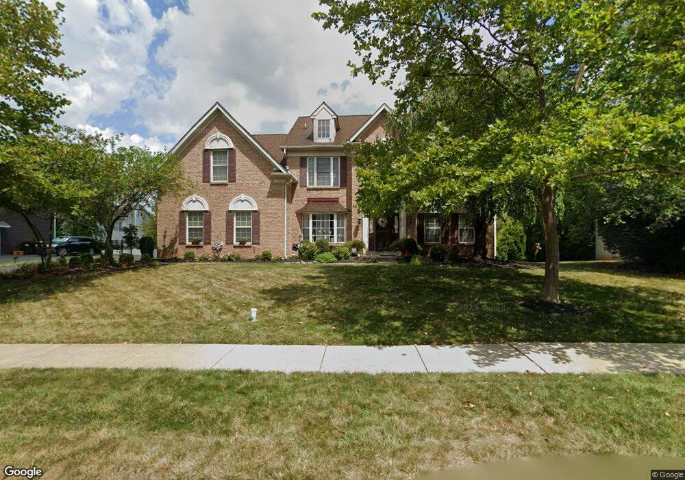
127 Avondale Dr North Wales, PA 19454
Estimated Value: $886,276 - $1,042,000
4
Beds
4
Baths
4,054
Sq Ft
$235/Sq Ft
Est. Value
About This Home
This home is located at 127 Avondale Dr, North Wales, PA 19454 and is currently estimated at $952,819, approximately $235 per square foot. 127 Avondale Dr is a home located in Montgomery County with nearby schools including Montgomery Elementary School, Pennbrook Middle School, and North Penn Senior High School.
Ownership History
Date
Name
Owned For
Owner Type
Purchase Details
Closed on
Jun 22, 2007
Sold by
Cutler Group Inc and Cutler David
Bought by
Miles Leroy and Miles Felicia
Current Estimated Value
Home Financials for this Owner
Home Financials are based on the most recent Mortgage that was taken out on this home.
Original Mortgage
$501,796
Outstanding Balance
$310,358
Interest Rate
6.39%
Estimated Equity
$642,461
Create a Home Valuation Report for This Property
The Home Valuation Report is an in-depth analysis detailing your home's value as well as a comparison with similar homes in the area
Home Values in the Area
Average Home Value in this Area
Purchase History
| Date | Buyer | Sale Price | Title Company |
|---|---|---|---|
| Miles Leroy | $557,551 | None Available |
Source: Public Records
Mortgage History
| Date | Status | Borrower | Loan Amount |
|---|---|---|---|
| Open | Miles Leroy | $501,796 |
Source: Public Records
Tax History Compared to Growth
Tax History
| Year | Tax Paid | Tax Assessment Tax Assessment Total Assessment is a certain percentage of the fair market value that is determined by local assessors to be the total taxable value of land and additions on the property. | Land | Improvement |
|---|---|---|---|---|
| 2025 | $12,046 | $322,920 | -- | -- |
| 2024 | $12,046 | $322,920 | -- | -- |
| 2023 | $11,492 | $322,920 | $0 | $0 |
| 2022 | $11,089 | $322,920 | $0 | $0 |
| 2021 | $10,426 | $322,920 | $0 | $0 |
| 2020 | $10,151 | $322,920 | $0 | $0 |
| 2019 | $9,961 | $322,920 | $0 | $0 |
| 2018 | $1,719 | $322,920 | $0 | $0 |
| 2017 | $9,535 | $322,920 | $0 | $0 |
| 2016 | $9,409 | $322,920 | $0 | $0 |
| 2015 | $8,985 | $322,920 | $0 | $0 |
| 2014 | $8,985 | $310,700 | $0 | $0 |
Source: Public Records
Map
Nearby Homes
- 964 Knapp Rd
- 3103 Hemmingway Dr
- 3406 Elizabeths Ct
- 1506 Naomis Ct
- 220 Hampton Green Dr
- 115 Castle Dr
- 502 Williamsburg Rd
- 1101 Barbaras Ct
- 825 Monticello Place
- 102 Gwynmont Dr
- 873 Lombardy Dr
- 117 Gwynmont Dr
- 1114 W Thomas Rd
- 1204 Vilsmeier Rd
- 407 Anthony Ct
- 203 Jonathan Dr
- 106 Jene Ct
- 1103 Lansdale Ave
- 1014 Lansdale Ave
- 1107 Lansdale Ave
- 129 Avondale Dr
- 125 Avondale Dr
- 110 Carson Dr
- 112 Carson Dr
- 108 Carson Dr
- 128 Avondale Dr
- 130 Avondale Dr
- 123 Avondale Dr
- 201 Avondale Dr
- 114 Carson Dr
- 106 Carson Dr
- 111 Carson Dr
- 116 Carson Dr
- 121 Avondale Dr
- 203 Avondale Dr
- 124 Avondale Dr
- 109 Carson Dr
- 113 Carson Dr
- 200 Avondale Dr
- 101 Dayton Dr S