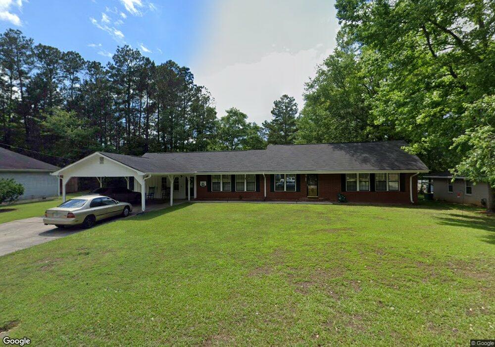
127 Bennett Cir Carrollton, GA 30117
Estimated Value: $321,000 - $372,000
3
Beds
2
Baths
1,886
Sq Ft
$179/Sq Ft
Est. Value
About This Home
This home is located at 127 Bennett Cir, Carrollton, GA 30117 and is currently estimated at $338,218, approximately $179 per square foot. 127 Bennett Cir is a home located in Carroll County with nearby schools including Carrollton Elementary School, Carrollton Upper Elementary School, and Carrollton Middle School.
Ownership History
Date
Name
Owned For
Owner Type
Purchase Details
Closed on
Sep 4, 2008
Sold by
Not Provided
Bought by
Douglas Brian
Current Estimated Value
Home Financials for this Owner
Home Financials are based on the most recent Mortgage that was taken out on this home.
Original Mortgage
$105,750
Interest Rate
6.49%
Mortgage Type
New Conventional
Purchase Details
Closed on
Feb 5, 2008
Sold by
Not Provided
Bought by
Douglas Brian
Purchase Details
Closed on
Apr 18, 1994
Bought by
Strickland Marty R
Purchase Details
Closed on
Oct 12, 1990
Bought by
Shaw
Create a Home Valuation Report for This Property
The Home Valuation Report is an in-depth analysis detailing your home's value as well as a comparison with similar homes in the area
Home Values in the Area
Average Home Value in this Area
Purchase History
| Date | Buyer | Sale Price | Title Company |
|---|---|---|---|
| Douglas Brian | $50,500 | -- | |
| Douglas Brian | $70,000 | -- | |
| Strickland Marty R | $74,000 | -- | |
| Shaw | $60,000 | -- |
Source: Public Records
Mortgage History
| Date | Status | Borrower | Loan Amount |
|---|---|---|---|
| Closed | Douglas Brian | $105,750 |
Source: Public Records
Tax History Compared to Growth
Tax History
| Year | Tax Paid | Tax Assessment Tax Assessment Total Assessment is a certain percentage of the fair market value that is determined by local assessors to be the total taxable value of land and additions on the property. | Land | Improvement |
|---|---|---|---|---|
| 2024 | $3,523 | $128,926 | $8,100 | $120,826 |
| 2023 | $3,523 | $117,757 | $8,100 | $109,657 |
| 2022 | $2,725 | $93,361 | $5,400 | $87,961 |
| 2021 | $2,314 | $79,263 | $4,000 | $75,263 |
| 2020 | $2,055 | $70,317 | $4,000 | $66,317 |
| 2019 | $1,873 | $63,496 | $4,000 | $59,496 |
| 2018 | $1,629 | $54,426 | $4,000 | $50,426 |
| 2017 | $1,637 | $54,426 | $4,000 | $50,426 |
| 2016 | $1,647 | $54,426 | $4,000 | $50,426 |
| 2015 | $817 | $26,449 | $4,000 | $22,450 |
| 2014 | $821 | $26,450 | $4,000 | $22,450 |
Source: Public Records
Map
Nearby Homes
- 114 Bennett Cir
- 317 Bledsoe St
- 521 Adamson Ave
- 509 Adamson Ave
- 112 Lane Dr
- 112 Lane Dr Unit LOT 68
- 202 Laney Dr
- 406 Harmon Ave
- 150 Adamson Dr
- Plan 2121 at Canterbury Villas
- Plan 2307 at Canterbury Villas
- 204 Chaucer Ln
- Plan 1522 at Canterbury Villas
- Plan 1634 at Canterbury Villas
- Plan 2628 at Canterbury Villas
- 210 Lane Dr Unit LOT 61
- 210 Lane Dr
- 212 Lane Dr Unit LOT 60
- 212 Lane Dr
- 214 Lane Dr
- 125 Bennett Cir
- 131 Bennett Cir
- 131A Bennett Cir
- 131A Bennett Cir
- 160 Bennett Cir
- 164 Bennett Cir
- 0 Bennett Cir Unit 8324587
- 0 Bennett Cir Unit 7044425
- 0 Bennett Cir
- 215 Bennett Cir
- 213 Bennet Cir Unit A
- 123 Bennett Cir
- 130 Bennett Cir
- 128 Bennett Cir
- 135 Bennett Cir
- 211 Bennett Cir
- 122 Bennett Cir
- 134 Bennett Cir
- 119 Bennett Cir
- 216 Bennett Cir