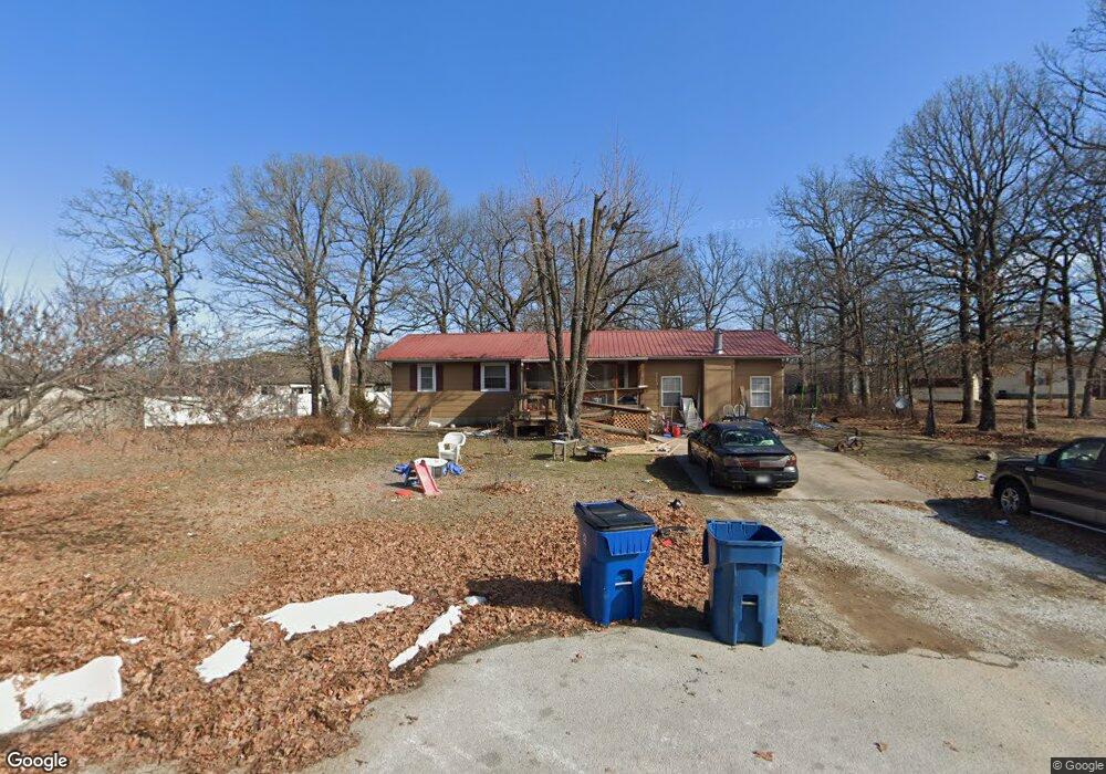
127 Cedar Ln Carl Junction, MO 64834
Briarbrook NeighborhoodEstimated Value: $178,437 - $257,000
3
Beds
2
Baths
1,508
Sq Ft
$136/Sq Ft
Est. Value
About This Home
This home is located at 127 Cedar Ln, Carl Junction, MO 64834 and is currently estimated at $205,609, approximately $136 per square foot. 127 Cedar Ln is a home located in Jasper County with nearby schools including Carl Junction Primary School (K-1), Carl Junction Intermediate School, and Carl Junction Primary School (2-3).
Ownership History
Date
Name
Owned For
Owner Type
Purchase Details
Closed on
Aug 15, 2014
Sold by
Sailor Catherine
Bought by
Manard John
Current Estimated Value
Home Financials for this Owner
Home Financials are based on the most recent Mortgage that was taken out on this home.
Original Mortgage
$62,037
Outstanding Balance
$47,254
Interest Rate
4.16%
Mortgage Type
New Conventional
Estimated Equity
$158,355
Purchase Details
Closed on
May 4, 2012
Sold by
Sailor Donald
Bought by
Sailor Catherine
Create a Home Valuation Report for This Property
The Home Valuation Report is an in-depth analysis detailing your home's value as well as a comparison with similar homes in the area
Home Values in the Area
Average Home Value in this Area
Purchase History
| Date | Buyer | Sale Price | Title Company |
|---|---|---|---|
| Manard John | -- | Cb Title Inc | |
| Sailor Catherine | -- | None Available |
Source: Public Records
Mortgage History
| Date | Status | Borrower | Loan Amount |
|---|---|---|---|
| Open | Manard John | $62,037 |
Source: Public Records
Tax History
| Year | Tax Paid | Tax Assessment Tax Assessment Total Assessment is a certain percentage of the fair market value that is determined by local assessors to be the total taxable value of land and additions on the property. | Land | Improvement |
|---|---|---|---|---|
| 2025 | $894 | $15,800 | $3,250 | $12,550 |
| 2024 | $896 | $14,090 | $3,250 | $10,840 |
| 2023 | $896 | $14,090 | $3,250 | $10,840 |
| 2022 | $876 | $13,770 | $3,250 | $10,520 |
| 2021 | $758 | $13,770 | $3,250 | $10,520 |
| 2020 | $717 | $12,840 | $3,250 | $9,590 |
| 2019 | $682 | $12,840 | $3,250 | $9,590 |
| 2018 | $652 | $12,360 | $0 | $0 |
| 2017 | $654 | $12,360 | $0 | $0 |
| 2016 | $675 | $12,880 | $0 | $0 |
Source: Public Records
Map
Nearby Homes
- 710 Briarbrook Dr
- 126 N Windwood
- 107 Foursome Ln
- 328 Briarbrook Dr
- 706 W Briarbrook Ln
- 106 Victoria Ln
- 128 Par Ln
- 807 Copper Oaks Dr
- 909 Silver Oaks Dr
- 306 Lakeview Ln
- 708 Danica Jo Ln
- 232 Hickory Place
- 901 Black Thorn Dr
- 913 W Briarbrook Ln
- 201 Tee Ln
- XXX Lone Elm
- 907 Silver Oaks Dr
- 1021 Copper Oaks Dr
- 910 Silver Oaks
- 908 Silver Oaks Dr
- 109 W Briarbrook Ln
- 111 W Briarbrook Ln
- 125 Cedar Ln
- 115 W Briarbrook Ln
- 113 W Briarbrook Ln
- 126 Cedar Ln
- 105 W Briarbrook Ln
- 117 W Briarbrook Ln
- 117 W Briarbrook Ln Unit 2
- 117 W Briarbrook Ln
- 117 W Briarbrook Ln
- 124 Cedar Ln
- 119 W Briarbrook Ln
- 123 Cedar Ln
- 612 Briarbrook Dr
- 612 Briarbrook Dr
- 122 W Briarbrook Ln
- 120 W Briarbrook Ln
- 120 W Briarbrook Ln
- 122 Cedar Ln
Your Personal Tour Guide
Ask me questions while you tour the home.