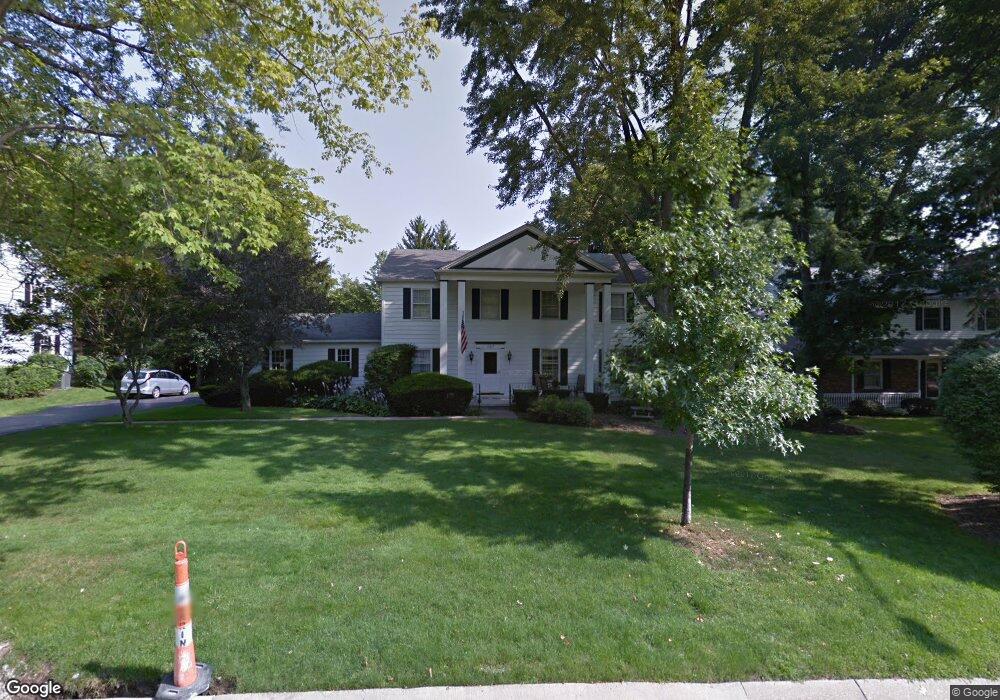
127 Colony Dr Hudson, OH 44236
Estimated Value: $408,000 - $475,000
4
Beds
3
Baths
2,408
Sq Ft
$185/Sq Ft
Est. Value
About This Home
This home is located at 127 Colony Dr, Hudson, OH 44236 and is currently estimated at $445,607, approximately $185 per square foot. 127 Colony Dr is a home located in Summit County with nearby schools including Ellsworth Hill Elementary School, East Woods Intermediate School, and Hudson Middle School.
Ownership History
Date
Name
Owned For
Owner Type
Purchase Details
Closed on
Jul 2, 2001
Sold by
Curtis Wesley B and Curtis Marilyn J
Bought by
Dilullo Patrick A and Dilullo Jane P
Current Estimated Value
Home Financials for this Owner
Home Financials are based on the most recent Mortgage that was taken out on this home.
Original Mortgage
$175,200
Outstanding Balance
$68,155
Interest Rate
7.27%
Estimated Equity
$377,452
Create a Home Valuation Report for This Property
The Home Valuation Report is an in-depth analysis detailing your home's value as well as a comparison with similar homes in the area
Home Values in the Area
Average Home Value in this Area
Purchase History
| Date | Buyer | Sale Price | Title Company |
|---|---|---|---|
| Dilullo Patrick A | $219,000 | Midland Commerce Group |
Source: Public Records
Mortgage History
| Date | Status | Borrower | Loan Amount |
|---|---|---|---|
| Open | Dilullo Patrick A | $175,200 |
Source: Public Records
Tax History Compared to Growth
Tax History
| Year | Tax Paid | Tax Assessment Tax Assessment Total Assessment is a certain percentage of the fair market value that is determined by local assessors to be the total taxable value of land and additions on the property. | Land | Improvement |
|---|---|---|---|---|
| 2025 | $5,661 | $110,863 | $18,680 | $92,183 |
| 2024 | $5,661 | $110,863 | $18,680 | $92,183 |
| 2023 | $5,661 | $110,863 | $18,680 | $92,183 |
| 2022 | $4,923 | $85,940 | $14,480 | $71,460 |
| 2021 | $4,931 | $85,940 | $14,480 | $71,460 |
| 2020 | $4,845 | $85,940 | $14,480 | $71,460 |
| 2019 | $6,224 | $102,540 | $16,390 | $86,150 |
| 2018 | $6,202 | $102,540 | $16,390 | $86,150 |
| 2017 | $5,324 | $102,600 | $16,390 | $86,210 |
| 2016 | $5,430 | $86,520 | $16,390 | $70,130 |
| 2015 | $5,324 | $86,520 | $16,390 | $70,130 |
| 2014 | $5,340 | $86,520 | $16,390 | $70,130 |
| 2013 | $5,167 | $81,770 | $16,390 | $65,380 |
Source: Public Records
Map
Nearby Homes
- 148 Colony Dr
- 5974 Anna Lee Dr
- 21 Keswick Dr
- 94 Fox Trace Ln
- 5937 Ogilby Dr
- 5791 Sunset Dr
- 1705 Barlow Rd
- 35 S Hayden Pkwy
- 21 Atterbury Blvd
- 116 W Case Dr
- 157 Hudson St
- 77 Atterbury Blvd Unit 106
- 5532 Hudson Dr
- 311 W Streetsboro St
- 181 Boston Mills Rd
- 180 Atterbury Blvd
- 6607 Dunbarton Dr
- 24 Morning Song Ln
- 2380 Victoria Pkwy
- 6751 Pheasants Ridge
- 135 Colony Dr
- 119 Colony Dr
- 126 Clairhaven Dr
- 132 Clairhaven Dr
- 118 Clairhaven Dr
- 128 Colony Dr
- 113 Colony Dr
- 141 Colony Dr
- 120 Colony Dr
- 134 Colony Dr
- 112 Clairhaven Dr
- 140 Clairhaven Dr
- 114 Colony Dr
- 142 Colony Dr
- 149 Colony Dr
- 146 Clairhaven Dr
- 101 Colony Dr
- 1949 Stoney Hill Dr
- 123 Clairhaven Dr
- 131 Clairhaven Dr