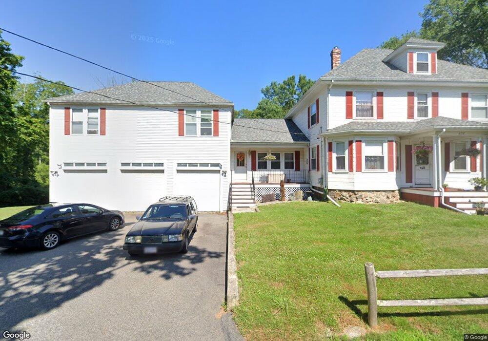
127 Cross St East Bridgewater, MA 02333
Estimated Value: $663,000 - $903,000
4
Beds
2
Baths
4,023
Sq Ft
$195/Sq Ft
Est. Value
About This Home
This home is located at 127 Cross St, East Bridgewater, MA 02333 and is currently estimated at $783,069, approximately $194 per square foot. 127 Cross St is a home located in Plymouth County with nearby schools including Gordon W Mitchell Middle School, East Bridgewater Jr./Sr. High School, and New England Baptist Academy.
Ownership History
Date
Name
Owned For
Owner Type
Purchase Details
Closed on
Nov 1, 2022
Sold by
Herman Marilynn E
Bought by
Persson Karl P
Current Estimated Value
Purchase Details
Closed on
Aug 10, 2022
Sold by
Persson Elsa Est
Bought by
Persson Karl P and Hermann Marilynn E
Purchase Details
Closed on
May 16, 1969
Bought by
Persson Elsa M
Create a Home Valuation Report for This Property
The Home Valuation Report is an in-depth analysis detailing your home's value as well as a comparison with similar homes in the area
Home Values in the Area
Average Home Value in this Area
Purchase History
| Date | Buyer | Sale Price | Title Company |
|---|---|---|---|
| Persson Karl P | -- | None Available | |
| Persson Karl P | -- | None Available | |
| Persson Elsa M | -- | -- |
Source: Public Records
Mortgage History
| Date | Status | Borrower | Loan Amount |
|---|---|---|---|
| Previous Owner | Persson Elsa M | $70,000 | |
| Previous Owner | Persson Elsa M | $15,000 | |
| Previous Owner | Persson Elsa M | $60,000 |
Source: Public Records
Tax History Compared to Growth
Tax History
| Year | Tax Paid | Tax Assessment Tax Assessment Total Assessment is a certain percentage of the fair market value that is determined by local assessors to be the total taxable value of land and additions on the property. | Land | Improvement |
|---|---|---|---|---|
| 2025 | $8,548 | $625,300 | $195,800 | $429,500 |
| 2024 | $8,429 | $609,000 | $188,300 | $420,700 |
| 2023 | $8,066 | $558,200 | $188,300 | $369,900 |
| 2022 | $8,204 | $525,900 | $171,200 | $354,700 |
| 2021 | $8,228 | $482,600 | $164,500 | $318,100 |
| 2020 | $8,297 | $479,900 | $158,500 | $321,400 |
| 2019 | $7,986 | $454,800 | $151,500 | $303,300 |
| 2018 | $7,980 | $444,300 | $151,500 | $292,800 |
| 2017 | $7,825 | $427,600 | $144,400 | $283,200 |
| 2016 | $7,647 | $421,100 | $144,400 | $276,700 |
| 2015 | $7,395 | $416,400 | $143,500 | $272,900 |
| 2014 | $7,110 | $409,300 | $140,500 | $268,800 |
Source: Public Records
Map
Nearby Homes
- 324 W Union St
- 505 N Central St
- 16 Pearl St
- 11 Willow Ave
- 41 Bedford St
- 38 Leland St
- 22 Water St
- 391 Bedford St
- 386 Bedford St
- 245-r Laurel St
- 11 Harmony Crossing
- 590 Bedford St
- 6 Andrea Way
- 261 Plymouth St
- 386 Matfield St
- 50 Belmont St
- 34 Captain Carlson Way
- 479 Central St
- 1 Thomas Cir
- 585 N Bedford St
- 281 W Union St
- 275 W Union St
- 17 Emerald St Unit 19
- 17 Emerald St Unit 17
- 17 Emerald St Unit 1
- 88 Cross St
- 25 Emerald St
- 7 Emerald St
- 235 W Union St Unit 237
- 325 W Union St
- 82 Cross St
- 244 W Union St
- 332 W Union St
- 225 W Union St
- 340 W Union St
- 76 Cross St
- Approx.301 Oak St
- 432 N Central St
- 357 W Union St
- 55 Cross St